File:2004 United States Senate election in Connecticut results map by county.svg

Size of this PNG preview of this SVG file: 800 × 588 pixels. Other resolutions: 320 × 235 pixels | 640 × 470 pixels | 1,024 × 752 pixels | 1,280 × 940 pixels | 2,560 × 1,880 pixels | 810 × 595 pixels.
Original file (SVG file, nominally 810 × 595 pixels, file size: 22 KB)
Captions
Captions
Add a one-line explanation of what this file represents
Summary edit
| Description |
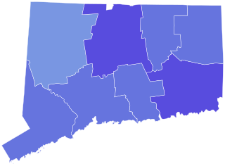
English: Map of County Results in U.S. Senate Election in Connecticut, 2004. |
| Date | |
| Source | Own work |
| Author | SpeedMcCool |
Licensing edit
I, the copyright holder of this work, hereby publish it under the following license:
This file is licensed under the Creative Commons Attribution-Share Alike 4.0 International license.
- You are free:
- to share – to copy, distribute and transmit the work
- to remix – to adapt the work
- Under the following conditions:
- attribution – You must give appropriate credit, provide a link to the license, and indicate if changes were made. You may do so in any reasonable manner, but not in any way that suggests the licensor endorses you or your use.
- share alike – If you remix, transform, or build upon the material, you must distribute your contributions under the same or compatible license as the original.
File history
Click on a date/time to view the file as it appeared at that time.
| Date/Time | Thumbnail | Dimensions | User | Comment | |
|---|---|---|---|---|---|
| current | 08:29, 19 April 2023 | | 810 × 595 (22 KB) | Putitonamap98 (talk | contribs) | shapes |
| 10:18, 15 December 2022 |  | 744 × 556 (45 KB) | Putitonamap98 (talk | contribs) | shapes | |
| 05:08, 29 August 2021 |  | 166 × 136 (14 KB) | Putitonamap98 (talk | contribs) | removed fishers island it is a part of new york not connecticut | |
| 04:38, 6 December 2018 |  | 166 × 136 (14 KB) | SpeedMcCool (talk | contribs) | User created page with UploadWizard |
You cannot overwrite this file.
File usage on Commons
The following 4 pages use this file:
File usage on other wikis
The following other wikis use this file:
- Usage on en.wikipedia.org