File:20111216-NRCS-LSC-0074 - Flickr - USDAgov.jpg
Original file (4,288 × 2,848 pixels, file size: 3.66 MB, MIME type: image/jpeg)
Captions
Captions
Summary edit
| Description |
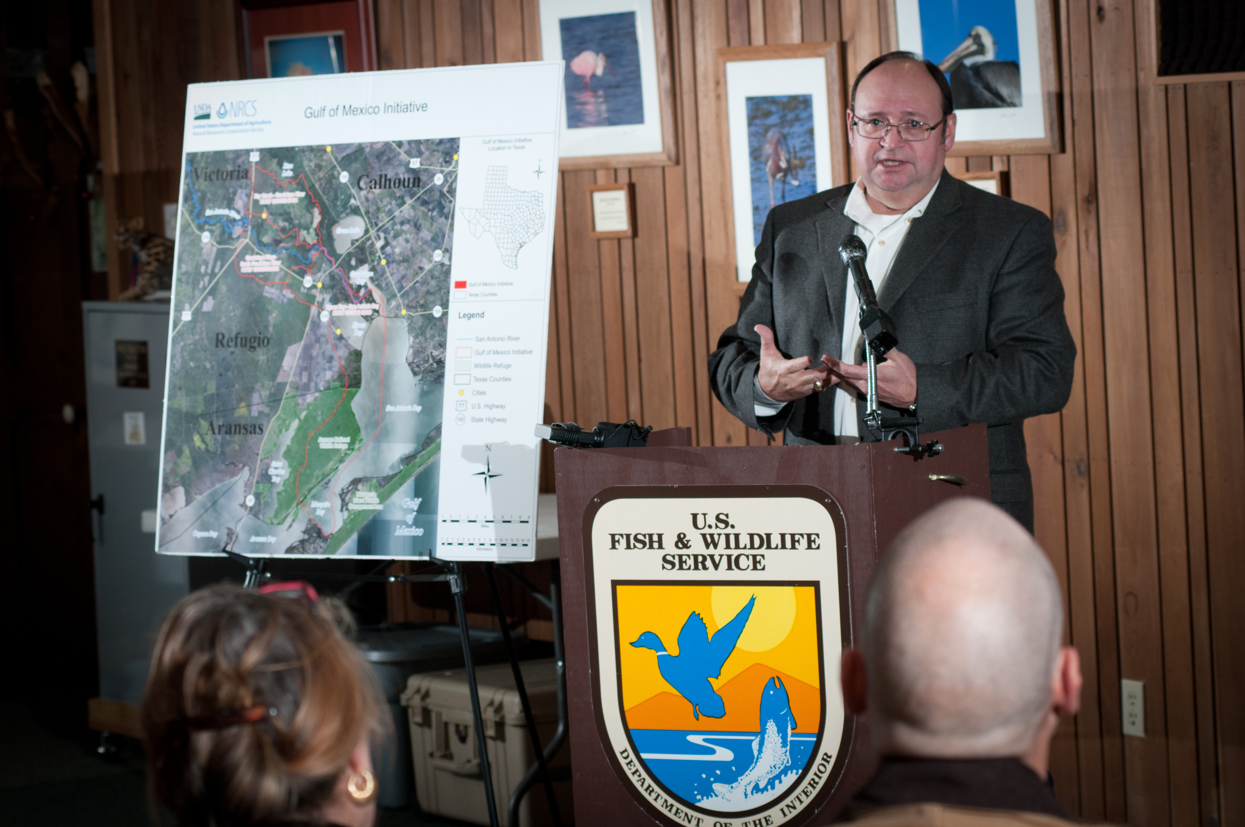
U.S. Department of Agriculture (USDA) Natural Resources Conservation Service (NRCS) State Conservationist Salvador Salinas with Federal and state partners, including representatives from U.S. Fish and Wildlife Service and local soil and water conservation districts (SWCDs) held a press conference at the Aransas National Wildlife Refuge, in Austwell, TX, on Friday, Dec. 16, 2011. Salinas covered the recent announcement of the USDA-NRCS Gulf of Mexico Initiative (GoMI) efforts to improve water quality, habitat, and the health of the Gulf ecosystem. “Launching this initiative is a top priority for NRCS in Texas because the Gulf of Mexico is one of our state’s premier natural resources. It provides vital habitat for wildlife, and creates jobs in industries that depend upon them. The health of this resource is essential to Texas as well as to the nation,” said Salinas. The Texas initiative focuses on three watersheds in Refugio, Calhoun, Victoria and Aransas counties and ultimately the Gulf of Mexico. “What is really compelling about GoMI and other similar conservation efforts is that they prove that Texas farmers and ranchers not only feed and clothe us and power our vehicles, but they can also help protect and restore our rivers and provide more habitat for wildlife,” stated Salinas. “That’s why it is important that this conservation project is not about taking productive farm land out of production. This is a working lands initiative, so that not only are we helping to restore the health of the Gulf, but we’re also helping to sustain and enhance the productivity of the Gulf’s farms and ranches.” USDA photo by Lance Cheung. |
| Date | |
| Source | 20111216-NRCS-LSC-0074 |
| Author | U.S. Department of Agriculture |
| Camera location | | View this and other nearby images on: OpenStreetMap |
|---|
Licensing edit
- You are free:
- to share – to copy, distribute and transmit the work
- to remix – to adapt the work
- Under the following conditions:
- attribution – You must give appropriate credit, provide a link to the license, and indicate if changes were made. You may do so in any reasonable manner, but not in any way that suggests the licensor endorses you or your use.
| This image was originally posted to Flickr by USDAgov at https://www.flickr.com/photos/41284017@N08/6551543827. It was reviewed on 25 December 2011 by FlickreviewR and was confirmed to be licensed under the terms of the cc-by-2.0. |
This image or file is a work of a United States Department of Agriculture employee, taken or made as part of that person's official duties. As a work of the U.S. federal government, the image is in the public domain.
|
 |
File history
Click on a date/time to view the file as it appeared at that time.
| Date/Time | Thumbnail | Dimensions | User | Comment | |
|---|---|---|---|---|---|
| current | 13:30, 25 December 2011 | | 4,288 × 2,848 (3.66 MB) | BotMultichillT (talk | contribs) | {{Information |Description=U.S. Department of Agriculture (USDA) Natural Resources Conservation Service (NRCS) State Conservationist Salvador Salinas with Federal and state partners, including representatives from U.S. Fish and Wildlife Service and local |
You cannot overwrite this file.
File usage on Commons
There are no pages that use this file.