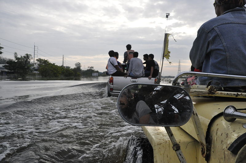
File:2011 Ayutthaya floods.JPG

Original file (4,288 × 2,848 pixels, file size: 4.2 MB, MIME type: image/jpeg)
Captions
Captions
Summary edit
| Description2011 Ayutthaya floods.JPG |
English: Major floods are occurring during the 2011 monsoon season in Thailand, most severely in the Chao Phraya but also in the Mekong River basin. Beginning in late July and continuing for over two months, the floods have caused 307 reported deaths, affected over 2.3 million people, and caused damages estimated at up to 156.7 billion baht (5.1 billion USD) as of 18 October. The flooding has inundated about six million hectares of land, over 300,000 hectares of which is farmland, in 58 provinces, from Chiang Mai in the North to parts of the capital city of Bangkok near the mouth of the Chao Phraya. It has been described as "the worst flooding yet in terms of the amount of water and people affected". Seven major industrial estates have been inundated by as much 3 meters (10 feet) and estimated it will be around for 40 days.
ไทย: อุทกภัยในประเทศไทย พ.ศ. 2554 เป็นอุทกภัยรุนแรงที่เกิดขึ้นระหว่างฤดูมรสุมในประเทศไทย พ.ศ. 2554 ผลกระทบหนักที่สุดอยู่ที่บริเวณที่ราบลุ่มแม่น้ำเจ้าพระยา รวมไปถึงที่ราบลุ่มแม่น้ำโขง เหตุการณ์กินเวลาตั้งแต่ปลายเดือนกรกฎาคมและยังคงดำเนินมามากกว่าสองเดือนจนถึงปัจจุบัน จนถึงวันที่ 28 ตุลาคม มีรายงานผู้เสียชีวิตแล้ว 377คน สูญหาย 3 คน และมีผู้ได้รับผลกระทบ 2.9 ล้านครัวเรือน หรือกว่า 9.5 ล้านคน[1] โดยประเมินความเสียหายอยู่ที่ 156,700 ล้านบาท ส่งผลกระทบต่อเศรษฐกิจโดยรวม 2.31 แสนล้านบาท
อุทกภัยดังกล่าวทำให้พื้นดินกว่า 150 ล้านไร่ (6 ล้านเฮกตาร์) ซึ่งในจำนวนนี้เป็นทั้งพื้นที่เกษตรกรรมและอุตสาหกรรมใน 63 จังหวัด 641 อำเภอ ตั้งแต่จังหวัดเชียงใหม่ สุโขทัย ตาก พิษณุโลก กำแพงเพชร ทางภาคเหนือ ไปจนถึง พิจิตร นครสวรรค์ อุทัยธานี ชัยนาท ลพบุรี สระบุรี สิงห์บุรี อ่างทอง สุพรรณบุรี ปทุมธานี นครนายก นนทบุรี พระนครศรีอยุธยา นครปฐม สมุทรสาคร ฉะเชิงเทรา สมุทรปราการ ปราจีนบุรี กรุงเทพมหานคร ในที่ราบลุ่มภาคกลาง ขอนแก่น มหาสารคาม ร้อยเอ็ด สุรินทร์ ศรีสะเกษ อุบลราชธานี กาฬสินธุ์ นครราชสีมา ในบริเวณที่ราบลุ่มแม่น้ำโขง อุทกภัยครั้งนี้ถูกกล่าวขานว่าเป็น "อุทกภัยครั้งร้ายแรงที่สุดทั้งในแง่ของปริมาณน้ำและจำนวนผู้ได้รับผลกระทบ" |
| Date | |
| Source | Own workAyutthaya Province |
| Author | ณวSuriya Thonawanik |
| Permission (Reusing this file) |
public domain |
Thailand
Licensing edit
| Copyleft: This work of art is free; you can redistribute it and/or modify it according to terms of the Free Art License. You will find a specimen of this license on the Copyleft Attitude site as well as on other sites. http://artlibre.org/licence/lal/enFALFree Art Licensefalsetrue |
File history
Click on a date/time to view the file as it appeared at that time.
| Date/Time | Thumbnail | Dimensions | User | Comment | |
|---|---|---|---|---|---|
| current | 01:01, 1 November 2011 |  | 4,288 × 2,848 (4.2 MB) | ณว (talk | contribs) | {{Information |Description ={{en|1=Major floods are occurring during the 2011 monsoon season in Thailand, most severely in the Chao Phraya but also in the Mekong River basin. Beginning in late July and continuing for over two months, the floods have ca |
You cannot overwrite this file.
File usage on Commons
There are no pages that use this file.
Metadata
This file contains additional information such as Exif metadata which may have been added by the digital camera, scanner, or software program used to create or digitize it. If the file has been modified from its original state, some details such as the timestamp may not fully reflect those of the original file. The timestamp is only as accurate as the clock in the camera, and it may be completely wrong.
| Camera manufacturer | NIKON CORPORATION |
|---|---|
| Camera model | NIKON D90 |
| Exposure time | 1/2,500 sec (0.0004) |
| F-number | f/8 |
| ISO speed rating | 2,000 |
| Date and time of data generation | 08:21, 18 October 2011 |
| Lens focal length | 18 mm |
| Orientation | Normal |
| Horizontal resolution | 300 dpi |
| Vertical resolution | 300 dpi |
| Software used | Ver.1.00 |
| File change date and time | 08:21, 18 October 2011 |
| White point chromaticity |
|
| Chromaticities of primarities |
|
| Color space transformation matrix coefficients |
|
| Y and C positioning | Co-sited |
| Exposure Program | Aperture priority |
| Exif version | 2.21 |
| Date and time of digitizing | 08:21, 18 October 2011 |
| Meaning of each component |
|
| Image compression mode | 4 |
| APEX exposure bias | 1 |
| Maximum land aperture | 3.6 APEX (f/3.48) |
| Metering mode | Pattern |
| Light source | Unknown |
| Flash | Flash did not fire |
| DateTime subseconds | 00 |
| DateTimeOriginal subseconds | 00 |
| DateTimeDigitized subseconds | 00 |
| Supported Flashpix version | 1 |
| Color space | Uncalibrated |
| Sensing method | One-chip color area sensor |
| File source | Digital still camera |
| Scene type | A directly photographed image |
| Custom image processing | Normal process |
| Exposure mode | Auto exposure |
| White balance | Auto white balance |
| Digital zoom ratio | 1 |
| Focal length in 35 mm film | 27 mm |
| Scene capture type | Standard |
| Scene control | High gain up |
| Contrast | Normal |
| Saturation | Normal |
| Sharpness | Normal |
| Subject distance range | Unknown |
| GPS tag version | 2.2.0.0 |