File:2011 Eritrea-Ethiopia earthquake2.jpg
Size of this preview: 523 × 599 pixels. Other resolutions: 209 × 240 pixels | 612 × 701 pixels.
Original file (612 × 701 pixels, file size: 104 KB, MIME type: image/jpeg)
Captions
Captions
Add a one-line explanation of what this file represents
Summary edit
| Description |
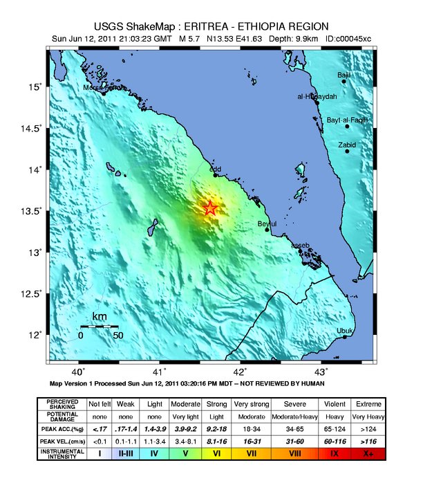
Español: Mapa de intensidad instrumental de sismo de 5.7º (2) de magnitud en la frontera de Eritrea y Etiopía, como parte del proceso eruptivo del complejo volcánico Enabro. El epicentro está marcado con una estrella. |
|||
| Date | ||||
| Source | https://earthquake.usgs.gov/earthquakes/shakemap/global/shake/c00045xc/ | |||
| Author | United States Geological Survey (USGS) | |||
| Permission (Reusing this file) |
|
File history
Click on a date/time to view the file as it appeared at that time.
| Date/Time | Thumbnail | Dimensions | User | Comment | |
|---|---|---|---|---|---|
| current | 12:12, 25 June 2011 | | 612 × 701 (104 KB) | Sebastián Spindler (talk | contribs) | {{Information |Description ={{es|1=Mapa de intensidad instrumental de sismo de 5.7º (2) de magnitud en la frontera de Eritrea y Etiopía, como parte del proceso eruptivo del complejo volcánico Enabro. El epicentro está marcado con una estrella.}} |S |
You cannot overwrite this file.
File usage on Commons
There are no pages that use this file.
File usage on other wikis
The following other wikis use this file:
- Usage on es.wikipedia.org