File:2011 flooding in Ayutthaya Province-EO-1-ALI, image 2.jpg

Original file (3,000 × 4,000 pixels, file size: 3.67 MB, MIME type: image/jpeg)
Captions
Captions
Summary edit
| Description |
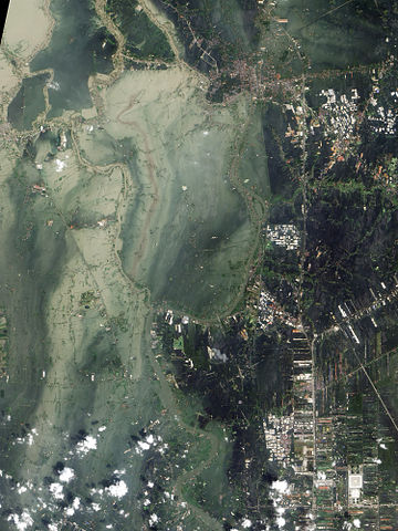
English: True-colour satellite image showing flooding in Ayutthaya and Pathum Thani Provinces in Central Thailand. Compare with File:2011 flooding in Ayutthaya Province-EO-1-ALI, image 1.jpg.
Original caption: The Chao Phraya River forms at the confluence of smaller rivers in central Thailand, and flows southward to the Gulf of Thailand. En route to the sea, the river passes through Ayutthaya. First established in the fourteenth century, Ayutthaya lies north of Thailand’s capital city of Bangkok, and the floods plaguing Thailand in October 2011 did not spare this historic city. The Advanced Land Imager (ALI) on NASA’s Earth Observing-1 (EO-1) satellite acquired these natural-color images of Ayutthaya on October 23, 2011 (top), and July 11, 2011 (bottom). In both images, the Chao Phraya River curves through the southwestern part of the city (image lower left). In October, however, the river has overflowed onto nearby floodplains, especially southwest of the river and west of Route 356. Fields, roads, and buildings have all been submerged by sediment-clogged flood water. Thailand’s monsoon generally lasts from mid-May to September. Because these images show the region at different times of year, some of the differences in water and vegetation could result from normal seasonal variations. However, the large expanse of flood water in October 2011 is unusual even in a monsoon season. Flooding forced the closure of manufacturing plants in Ayutthaya, according to news reports. The city is a United Nations Educational, Scientific and Cultural Organization (UNESCO) World Heritage site. On October 12, UNESCO Bangkok announced a planned assessment of flood damage to Ayutthaya, requested by the government of Thailand. |
| Date | |
| Source | Nasa Earth Observatory |
| Author | NASA Earth Observatory image created by Jesse Allen and Robert Simmon, using EO-1 ALI data provided courtesy of the NASA EO-1 team and the United States Geological Survey. |
| Camera location | | View this and other nearby images on: OpenStreetMap |
|---|
Licensing edit
| This file is in the public domain in the United States because it was solely created by NASA. NASA copyright policy states that "NASA material is not protected by copyright unless noted". (See Template:PD-USGov, NASA copyright policy page or JPL Image Use Policy.) | ||
 |
Warnings:
|
File history
Click on a date/time to view the file as it appeared at that time.
| Date/Time | Thumbnail | Dimensions | User | Comment | |
|---|---|---|---|---|---|
| current | 09:57, 1 November 2011 | | 3,000 × 4,000 (3.67 MB) | Paul 012 (talk | contribs) |
You cannot overwrite this file.
File usage on Commons
There are no pages that use this file.
File usage on other wikis
The following other wikis use this file: