File:2016 Election Congressional District Method Map.svg

Size of this PNG preview of this SVG file: 800 × 464 pixels. Other resolutions: 320 × 186 pixels | 640 × 372 pixels | 1,024 × 594 pixels | 1,280 × 743 pixels | 2,560 × 1,486 pixels | 1,242 × 721 pixels.
Original file (SVG file, nominally 1,242 × 721 pixels, file size: 3.9 MB)
Captions
Captions
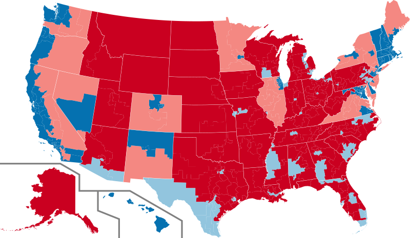
The dark colors indicate which candidate won that state's overall popular vote.
Summary edit
| Description |
English: A map that shows which candidate won which congressional district in the 2016 Presidential Elections Español: Un mapa que muestra qué candidato ganó en qué distrito del Congreso en las elecciones presidenciales estadounidenses de 2016 |
| Date | |
| Source | Own work |
| Author | Brobbz |
Licensing edit
I, the copyright holder of this work, hereby publish it under the following license:
This file is licensed under the Creative Commons Attribution-Share Alike 4.0 International license.
- You are free:
- to share – to copy, distribute and transmit the work
- to remix – to adapt the work
- Under the following conditions:
- attribution – You must give appropriate credit, provide a link to the license, and indicate if changes were made. You may do so in any reasonable manner, but not in any way that suggests the licensor endorses you or your use.
- share alike – If you remix, transform, or build upon the material, you must distribute your contributions under the same or compatible license as the original.
File history
Click on a date/time to view the file as it appeared at that time.
| Date/Time | Thumbnail | Dimensions | User | Comment | |
|---|---|---|---|---|---|
| current | 21:23, 25 August 2021 | | 1,242 × 721 (3.9 MB) | Brobbz (talk | contribs) | Uploaded own work with UploadWizard |
You cannot overwrite this file.
File usage on Commons
There are no pages that use this file.