File:2019-03-23 - Mavic Pro -3941.jpg
Original file (5,472 × 3,648 pixels, file size: 510 KB, MIME type: image/jpeg)
Captions
Captions
Summary edit
| Description |
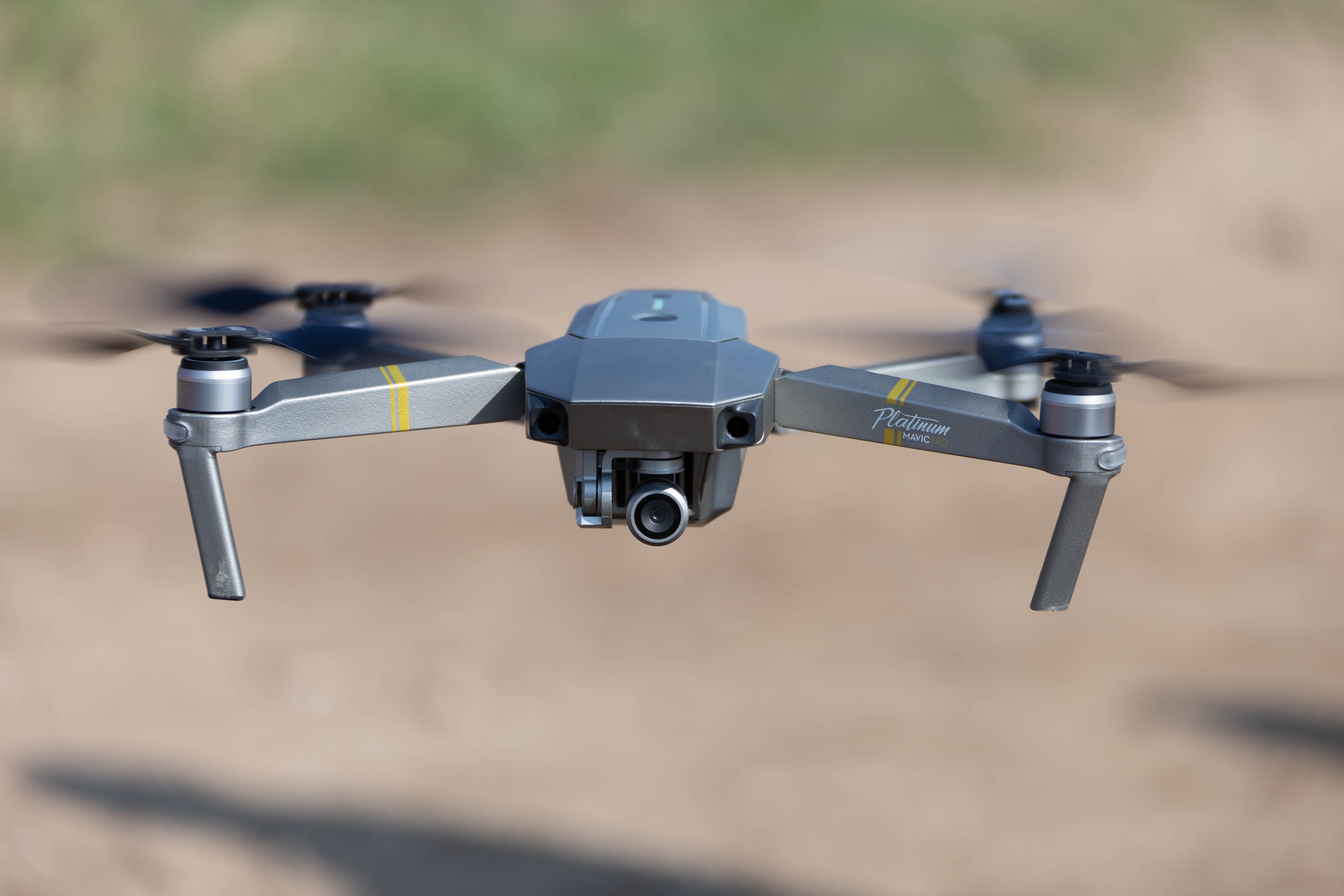
Deutsch: Mavic Pro Platinum mit Drittanbieter-Akku (eckige LEDs, Farbabweichung) und LowNoise-Rotoren vom Typ "Master Airscrew Stealth"
English: Mavic Pro Platinum with third-party LiPo (LEDs & color different) and "Master Airscrew Stealth" low-noise-blades |
||||||||||||||||||||||
| Date | |||||||||||||||||||||||
| Source | Own work | ||||||||||||||||||||||
| Author |
|
||||||||||||||||||||||
| Permission (Reusing this file) |
This file is licensed under the Creative Commons Attribution-Share Alike 3.0 Germany license.
 Reusing this image Licence: CC BY-SA 3.0-de via Wikimedia Commons This image was published by Sven Teschke under the free licence CC BY-SA 3.0-de, which also allows the usage outside of Wikipedia under the following conditions:
Please send me a specimen copy or the URL of the website where the image is used. Feel free to contact me via eMail steschke@web.de for any questions or in case you need...
Only the terms and conditions mentioned above authorize the free use of this image. Any infringement causes a copyright violation, that may result in a penelaty fee of five times the fee suggested by the MFM, inter alia.
|
||||||||||||||||||||||
| Attribution (required by the license) | Foto: Sven Teschke / | ||||||||||||||||||||||
| Camera location | | View this and other nearby images on: OpenStreetMap |
|---|
This image has been assessed using the Quality image guidelines and is considered a Quality image.
|
File history
Click on a date/time to view the file as it appeared at that time.
| Date/Time | Thumbnail | Dimensions | User | Comment | |
|---|---|---|---|---|---|
| current | 22:04, 24 March 2019 | | 5,472 × 3,648 (510 KB) | Steschke (talk | contribs) | Uploaded with LrMediaWiki 0.8.0, LR 8.2 Win |
You cannot overwrite this file.
File usage on Commons
More than 100 pages use this file. The following list shows the first 100 pages that use this file only. A full list is available.
- User:Ordercrazy/Drone
- User:Steschke/gallery
- User talk:Ordercrazy
- Commons:17. Fotoworkshop/Fotos
- File:Aletshofen Luft (03).jpg
- File:Aletshofen Luftbild.jpg
- File:Aletshofen Luftbild 01.jpg
- File:Amberg, Blick auf die Kurzwellensendeanlage Wertachtal.jpg
- File:Amberg (Unterallgäu).jpg
- File:Amberg (Unterallgäu) (02).jpg
- File:Amberg (Unterallgäu) (03).jpg
- File:Amberg (Unterallgäu) (04).jpg
- File:Amberg (Unterallgäu) (05).jpg
- File:Amberg (Unterallgäu) (06).jpg
- File:Amberg Senderstrasse.jpg
- File:Amberg Senderstrasse (02).jpg
- File:Amberg Senderstrasse (03).jpg
- File:Amberg Unterallgäu.jpg
- File:Amberg Unterallgäu (02).jpg
- File:Amberg Unterallgäu (03).jpg
- File:Amberg Unterallgäu (04).jpg
- File:Amberg Unterallgäu (05).jpg
- File:Bruderhof und Klafferberg in Scherstetten.jpg
- File:Buchloe, Industriegebiet.jpg
- File:Dillishausen und Eschenloher Muehle.jpg
- File:Ettringen (Wertach).jpg
- File:Ettringen (Wertach) (02).jpg
- File:Ettringen (Wertach) (03).jpg
- File:Ettringen (Wertach) (04).jpg
- File:Ettringen (Ziegelstadel).jpg
- File:Ettringen Einöde Kugelmann.jpg
- File:Felder bei Siebnach.jpg
- File:Felder vor Buchloe und Wiedergeltingen.jpg
- File:Felder vor Buchloe und Wiedergeltingen (02).jpg
- File:Forsthofen.jpg
- File:Forsthofen Luft.jpg
- File:Forsthofen Luft (02).jpg
- File:Funkmast Traunried.jpg
- File:Geiselhof Scherstetten.jpg
- File:Industriegebiet Türkheim.jpg
- File:Industriegebiet Türkheim 01.jpg
- File:Kirch-Siebnach.jpg
- File:Kirch-Siebnach (02).jpg
- File:Kirch-Siebnach beim Bergsepp.jpg
- File:Kirch-Siebnach mit St Georg.jpg
- File:Kirchdorf bei Bad Woerishofen.jpg
- File:Langweidbach und Siebnach.jpg
- File:Langweidbach und Siebnach (02).jpg
- File:Lehmgrube Traunried.jpg
- File:Lehmgrube Traunried (02).jpg
- File:Lehmgrube Traunried (03).jpg
- File:Luftbild mit schraegen Linien.jpg
- File:Luftbild öst. Türkheim.jpg
- File:Muehlbach zwischen Siebnach und Hoefen.jpg
- File:Muehlbach zwischen Siebnach und Hoefen (02).jpg
- File:Muehlbach zwischen Siebnach und Hoefen (03).jpg
- File:Muehlbach zwischen Siebnach und Hoefen (04).jpg
- File:Oberhoefen Luftbild (02).jpg
- File:Oberhoefen Luftbild (03).jpg
- File:Oberhöfen Luftbild.jpg
- File:Oberhöfen Luftbild (02).jpg
- File:Oberhöfen Luftbild (03).jpg
- File:Oberhöfen Luftbild (04).jpg
- File:Oberhöfen Luftbild (05).jpg
- File:Oberrammingen Luftbild.jpg
- File:Ostettrinen mit UPM.jpg
- File:Ostettrinen mit UPM (02).jpg
- File:ST2027 Scherstetten.jpg
- File:ST2027 Unterallgäu.jpg
- File:ST2027 mit Burgstall Bruderhof.jpg
- File:Salamander Fabrik Türkheim 01.jpg
- File:Salamander Fabrik Türkheim 01 (02).jpg
- File:Salamander Fabrik Türkheim 01 (03).jpg
- File:Salamander Fabrik Türkheim 01 (04).jpg
- File:Salamander Fabrik Türkheim 01 (05).jpg
- File:Salamander Fabrik Türkheim 01 (06).jpg
- File:Scharlach (river).jpg
- File:Scharlach (river) (02).jpg
- File:Scharlach (river) (03).jpg
- File:Scharlach und Schwabegg.jpg
- File:Scherstetten Luft.jpg
- File:Scherstetten Luft (02).jpg
- File:Scherstetten mit Schmutter 07.jpg
- File:Scherstetten mit Schmutter 07 (02).jpg
- File:Scherstetten mit Schmutter 07 (03).jpg
- File:Scherstetten mit Schmutter und Bruderhof.jpg
- File:Scherstetten mit Schmutter und Bruderhof (02).jpg
- File:Scherstetten mit Schmutter und Bruderhof (03).jpg
- File:Scherstetten mit Schmutter und Bruderhof (04).jpg
- File:Scherstetten mit Schmutter und Bruderhof (05).jpg
- File:Scherstetten mit Schmutter und Bruderhof (06).jpg
- File:Siebnach Luftbild.jpg
- File:Siebnach Luftbild (02).jpg
- File:Traunried.jpg
- File:Traunried (02).jpg
- File:Traunried (03).jpg
- File:Tuerkheim Golfplatz.jpg
- File:Tuerkheim Golfplatz 03.jpg
- File:Weiher bei Ettringen.jpg
- File:Wertachauen bei Höfen.jpg
.jpg)
.jpg)
_(02).jpg)
_(03).jpg)
_(04).jpg)
_(05).jpg)
_(06).jpg)
.jpg)
.jpg)
.jpg)
.jpg)
.jpg)
.jpg)
.jpg)
_(02).jpg)
_(03).jpg)
_(04).jpg)
.jpg)
.jpg)
.jpg)
.jpg)
.jpg)
.jpg)
.jpg)
.jpg)
.jpg)
.jpg)
.jpg)
.jpg)
.jpg)
.jpg)
.jpg)
.jpg)
.jpg)
.jpg)
.jpg)
.jpg)
.jpg)
.jpg)
.jpg)
_(02).jpg)
_(03).jpg)
.jpg)
.jpg)
.jpg)
.jpg)
.jpg)
.jpg)
.jpg)
.jpg)
.jpg)
.jpg)
.jpg)
View more links to this file.
File usage on other wikis
The following other wikis use this file:
- Usage on en.wikipedia.org
- Usage on fr.wikipedia.org
- Usage on hr.wikipedia.org
- Usage on it.wikipedia.org
- Usage on www.wikidata.org