File:20190624.Kaiser-Franz-Joseph-Höhe, Grossglockner.-019.jpg

Size of this preview: 800 × 450 pixels. Other resolutions: 320 × 180 pixels | 640 × 360 pixels | 1,024 × 576 pixels | 1,280 × 720 pixels | 2,560 × 1,440 pixels | 5,312 × 2,988 pixels.
Original file (5,312 × 2,988 pixels, file size: 8.04 MB, MIME type: image/jpeg)
Captions
Captions
Add a one-line explanation of what this file represents
Summary edit
| Description |
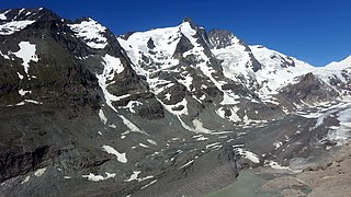
Deutsch: Die Kaiser-Franz-Josefs-Höhe ist Teil der Großglockner-Hochalpenstraße. Der Endpunkt einer Stichstraße und Aussichtspunkt befindet sich in Österreich in der Glocknergruppe auf Kärntner Gebiet in einer Höhe von 2369 m ü. A. Die Kaiser-Franz-Josefs-Höhe ist mit Fahrzeugen nur über die mautpflichtige Großglockner-Hochalpenstraße sowohl von Salzburg als auch von Kärnten erreichbar. Dieser Aussichtspunkt ist nach dem Besuch des Kaiserpaares Franz Joseph I. und Elisabeth, Sisi, im Jahr 1856 benannt. Der 26-jährige Monarch wünschte die Pasterze zu sehen und wanderte von Heiligenblut vier Stunden lang mit Gefolge die 1.100 Höhenmeter hinauf |
| Date | |
| Source | Own work |
| Author | Bybbisch94, Christian Gebhardt |
| Camera location | | View this and other nearby images on: OpenStreetMap |
|---|
Licensing edit
I, the copyright holder of this work, hereby publish it under the following license:
This file is licensed under the Creative Commons Attribution-Share Alike 4.0 International license.
- You are free:
- to share – to copy, distribute and transmit the work
- to remix – to adapt the work
- Under the following conditions:
- attribution – You must give appropriate credit, provide a link to the license, and indicate if changes were made. You may do so in any reasonable manner, but not in any way that suggests the licensor endorses you or your use.
- share alike – If you remix, transform, or build upon the material, you must distribute your contributions under the same or compatible license as the original.
| Annotations | This image is annotated: View the annotations at Commons |
File history
Click on a date/time to view the file as it appeared at that time.
| Date/Time | Thumbnail | Dimensions | User | Comment | |
|---|---|---|---|---|---|
| current | 10:07, 9 January 2022 | | 5,312 × 2,988 (8.04 MB) | Bybbisch94 (talk | contribs) | Uploaded own work with UploadWizard |
You cannot overwrite this file.
File usage on Commons
The following page uses this file: