File:2021-03-29 Wendezeller Ring 02.JPG

Size of this preview: 400 × 600 pixels. Other resolutions: 160 × 240 pixels | 320 × 480 pixels | 512 × 768 pixels | 683 × 1,024 pixels | 1,563 × 2,344 pixels.
Original file (1,563 × 2,344 pixels, file size: 1.62 MB, MIME type: image/jpeg)
Captions
Captions
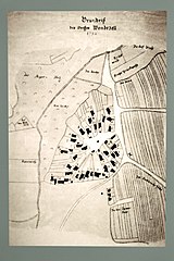
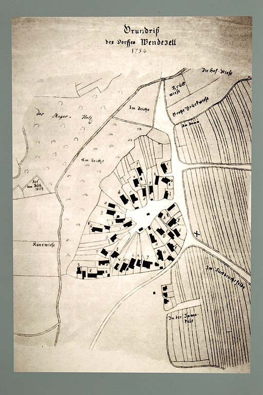
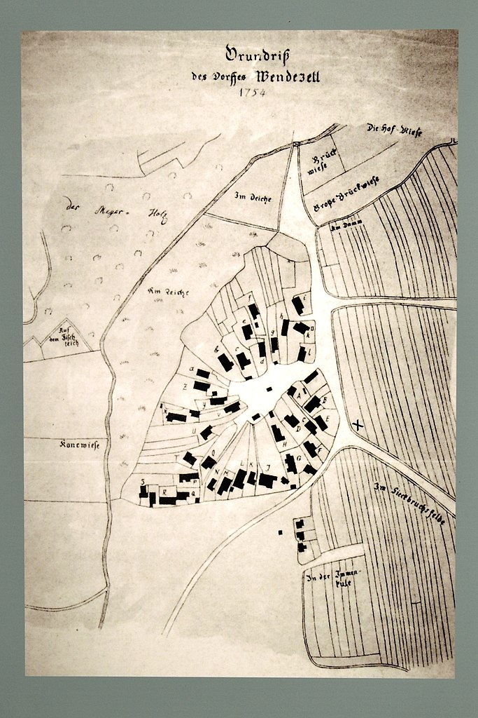
"Ground plan of the village of Wendezell 1754", detail of the information board on Wendezeller Ring in the Wendeburg district of Wendezell
Summary edit
| Description |
Deutsch: "Grundriss des Dorfes Wendezell 1754", Detail der Informationstafel am Wendezeller Ring im Wendeburger Ortsteil Wendezell
English: "Ground plan of the village of Wendezell 1754", detail of the information board on Wendezeller Ring in the Wendeburg district of Wendezell
Polski: "Plan miejscowości Wendezell 1754", detal tablicy informacyjnej przy Wendezeller Ring w dzielnicy Wendeburga Wendezelle |
||||||||||||||||
| Source | Own work | ||||||||||||||||
| Author |
|
||||||||||||||||
| Camera location | | View this and other nearby images on: OpenStreetMap |
|---|
Licensing edit
I, the copyright holder of this work, hereby publish it under the following license:
This file is licensed under the Creative Commons Attribution-Share Alike 4.0 International license.
- You are free:
- to share – to copy, distribute and transmit the work
- to remix – to adapt the work
- Under the following conditions:
- attribution – You must give appropriate credit, provide a link to the license, and indicate if changes were made. You may do so in any reasonable manner, but not in any way that suggests the licensor endorses you or your use.
- share alike – If you remix, transform, or build upon the material, you must distribute your contributions under the same or compatible license as the original.
File history
Click on a date/time to view the file as it appeared at that time.
| Date/Time | Thumbnail | Dimensions | User | Comment | |
|---|---|---|---|---|---|
| current | 09:35, 30 March 2021 | | 1,563 × 2,344 (1.62 MB) | Bärbel Miemietz (talk | contribs) | {{Information|Description= {{de|"Grundriss des Dorfes Wendezell 1754", Detail der Informationstafel am Wendezeller Ring im Wendeburger Ortsteil Wendezell}} {{en|"Ground plan of the village of Wendezell 1754", detail of the information board on Wendezeller Ring in the Wendeburg district of Wendezell}} {{pl|"Plan miejscowości Wendezell 1754", detal tablicy informacyjnej przy Wendezeller Ring w dzielnicy Wendeburga Wendezelle}} |Source={{own}} |Date= |Author= {{Creator|Wikidata=Q104455078}} |Per... |
You cannot overwrite this file.
File usage on Commons
The following page uses this file:
File usage on other wikis
The following other wikis use this file:
- Usage on de.wikipedia.org
- Usage on nl.wikipedia.org
- Usage on www.wikidata.org