File:2021 Kansas wildfires satellite.jpg

Original file (900 × 566 pixels, file size: 185 KB, MIME type: image/jpeg)
Captions
Captions
Summary edit
| Description |
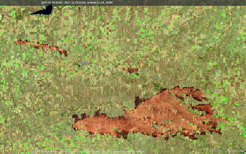
English: Burn scars of multiple wildfires from the December 15th Kansas wildfire siege. |
| Date | |
| Source | https://twitter.com/NWSHastings/status/1474816397100257280 |
| Author | Copernicus Sentinel-2, ESA |
Licensing edit

|
This image contains data from a satellite in the Copernicus Programme, such as Sentinel-1, Sentinel-2 or Sentinel-3. Attribution is required when using this image.
Attribution: Contains modified Copernicus Sentinel data 2021
The use of Copernicus Sentinel Data is regulated under EU law (Commission Delegated Regulation (EU) No 1159/2013 and Regulation (EU) No 377/2014). Relevant excerpts:
Free access shall be given to GMES dedicated data [...] made available through GMES dissemination platforms [...].
Access to GMES dedicated data [...] shall be given for the purpose of the following use in so far as it is lawful:
GMES dedicated data [...] may be used worldwide without limitations in time.
GMES dedicated data and GMES service information are provided to users without any express or implied warranty, including as regards quality and suitability for any purpose. |
File history
Click on a date/time to view the file as it appeared at that time.
| Date/Time | Thumbnail | Dimensions | User | Comment | |
|---|---|---|---|---|---|
| current | 23:34, 29 December 2021 | | 900 × 566 (185 KB) | JoleBruh (talk | contribs) | Uploaded a work by NWS Hastings from https://twitter.com/NWSHastings/status/1474816397100257280 with UploadWizard |
You cannot overwrite this file.
File usage on Commons
There are no pages that use this file.
File usage on other wikis
The following other wikis use this file:
- Usage on en.wikipedia.org