File:2021 United Kingdom local elections in district, borough and unitary councils.svg

Size of this PNG preview of this SVG file: 550 × 599 pixels. Other resolutions: 220 × 240 pixels | 441 × 480 pixels | 705 × 768 pixels | 940 × 1,024 pixels | 1,880 × 2,048 pixels | 1,536 × 1,673 pixels.
Original file (SVG file, nominally 1,536 × 1,673 pixels, file size: 15.62 MB)
Captions
Captions
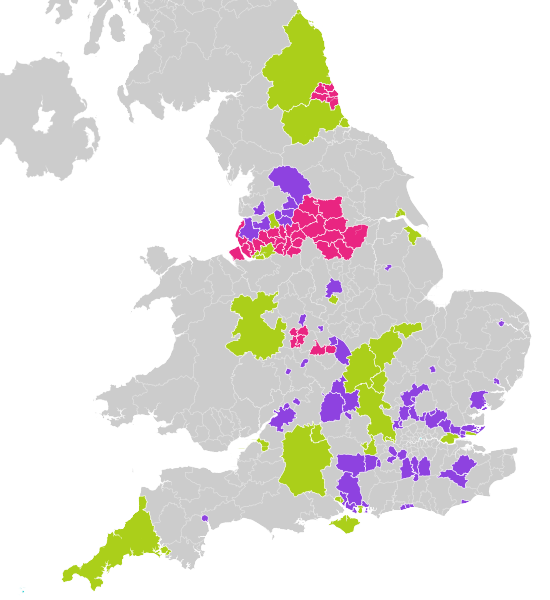
Map of district, borough and unitary councils up for election in the UK in 2021.
Summary edit
| Description |
English: Map of district, borough and unitary councils up for election in the UK in 2021.
Key: Metropolitan borough
Unitary authority
District council
Council of the Isles of Scilly and the City of London Corporation
No election |
| Date | |
| Source |
|
| Author | Ralbegen, using |
Licensing edit
This file is licensed under the Creative Commons Attribution-Share Alike 3.0 Unported license.
- You are free:
- to share – to copy, distribute and transmit the work
- to remix – to adapt the work
- Under the following conditions:
- attribution – You must give appropriate credit, provide a link to the license, and indicate if changes were made. You may do so in any reasonable manner, but not in any way that suggests the licensor endorses you or your use.
- share alike – If you remix, transform, or build upon the material, you must distribute your contributions under the same or compatible license as the original.
File history
Click on a date/time to view the file as it appeared at that time.
| Date/Time | Thumbnail | Dimensions | User | Comment | |
|---|---|---|---|---|---|
| current | 12:30, 23 February 2021 | | 1,536 × 1,673 (15.62 MB) | Ralbegen (talk | contribs) | Removed Cumbria councils |
| 20:12, 20 November 2020 |  | 1,536 × 1,673 (15.66 MB) | Ralbegen (talk | contribs) | Added NI | |
| 21:44, 11 November 2020 |  | 1,536 × 1,664 (13.96 MB) | Ralbegen (talk | contribs) | Rescaled so the borders look neater; added ghost borders of authorities without elections | |
| 13:59, 11 November 2020 |  | 768 × 832 (8.86 MB) | Ralbegen (talk | contribs) | Uploaded a work by Ralbegen, using from Ordnance Survey [https://www.ordnancesurvey.co.uk/opendatadownload/products.html OpenData]: *County boundaries (from Boundary-Line product) *Coastline data for Great Britain (from VectorMap District product) with UploadWizard |
You cannot overwrite this file.
File usage on Commons
The following 4 pages use this file:
File usage on other wikis
The following other wikis use this file:
- Usage on en.wikipedia.org