File:21-07-014-bridge.jpg
![File:21-07-014-bridge.jpg](https://upload.wikimedia.org/wikipedia/commons/thumb/4/4f/21-07-014-bridge.jpg/800px-21-07-014-bridge.jpg?20210916211703)
Original file (2,048 × 1,397 pixels, file size: 2.79 MB, MIME type: image/jpeg)
Captions
Captions
Summary
editDescription21-07-014-bridge.jpg |
English:
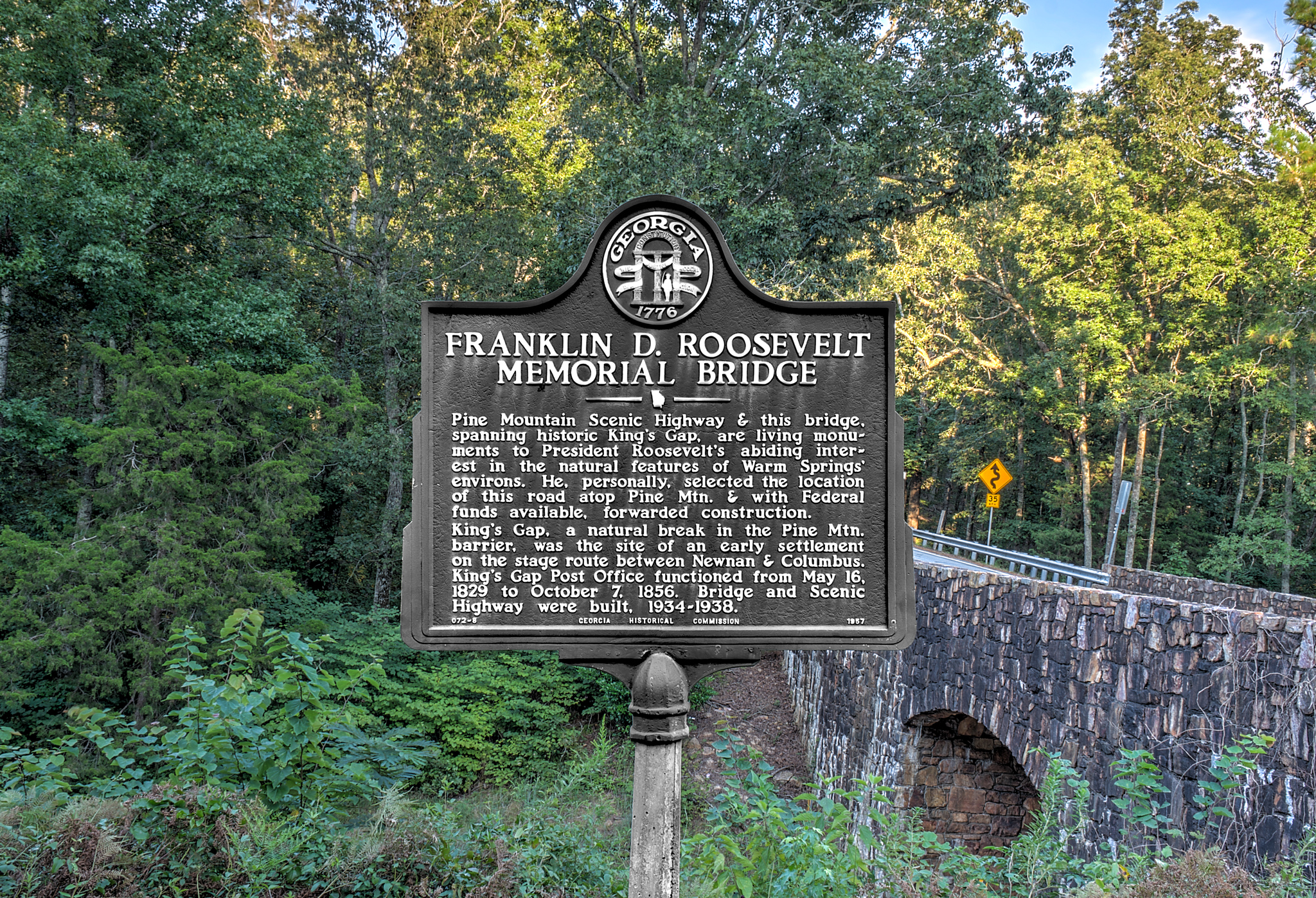
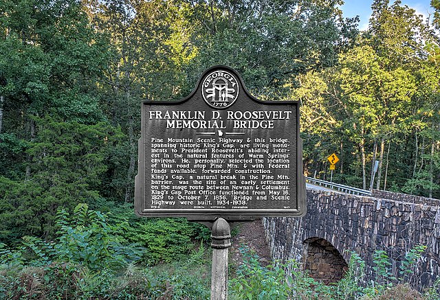
Franklin D. Roosevelt Memorial Bridge Pine Mountain Scenic Highway and this bridge, spanning historic King’s Gap, are living monuments to President Roosevelt’s abiding interest in the natural features of Warm Springs’ environs. He, personally, selected the location of this road atop Pine Mountain. and with Federal funds available, forwarded construction. King’s Gap, a natural break in the Pine Mountain barrier, was the site of an early settlement on the stage route between Newnan and Columbus. King’s Gap Post Office functioned from May 16, 1829 to October 7, 1856. Bridge and Scenic Highway were built, 1934-1938. |
Date | |
Source | Own work |
Author | Dsdugan |
Camera location | 32° 50′ 26.94″ N, 84° 48′ 33.79″ W ![]() | View this and other nearby images on: OpenStreetMap | ![]() |
---|
Licensing
edit![]() ![]() |
This file is made available under the Creative Commons CC0 1.0 Universal Public Domain Dedication. |
The person who associated a work with this deed has dedicated the work to the public domain by waiving all of their rights to the work worldwide under copyright law, including all related and neighboring rights, to the extent allowed by law. You can copy, modify, distribute and perform the work, even for commercial purposes, all without asking permission.
http://creativecommons.org/publicdomain/zero/1.0/deed.enCC0Creative Commons Zero, Public Domain Dedicationfalsefalse |
File history
Click on a date/time to view the file as it appeared at that time.
Date/Time | Thumbnail | Dimensions | User | Comment | |
---|---|---|---|---|---|
current | 21:17, 16 September 2021 | ![]() | 2,048 × 1,397 (2.79 MB) | Dsdugan (talk | contribs) | Uploaded own work with UploadWizard |
You cannot overwrite this file.
File usage on Commons
The following 2 pages use this file:
File usage on other wikis
The following other wikis use this file:
- Usage on en.wikipedia.org
Metadata
This file contains additional information such as Exif metadata which may have been added by the digital camera, scanner, or software program used to create or digitize it. If the file has been modified from its original state, some details such as the timestamp may not fully reflect those of the original file. The timestamp is only as accurate as the clock in the camera, and it may be completely wrong.
Camera manufacturer | NIKON CORPORATION |
---|---|
Camera model | NIKON D5300 |
Exposure time | 1/4 sec (0.25) |
F-number | f/16 |
ISO speed rating | 100 |
Date and time of data generation | 19:13, 3 September 2021 |
Lens focal length | 23 mm |
Latitude | 32° 50′ 24.59″ N |
Longitude | 84° 48′ 36.74″ W |
Altitude | 298 meters above sea level |
Software used | GraphicConverter 10 (10.7.5) |
File change date and time | 12:08, 15 September 2021 |
Exposure Program | Manual |
Date and time of digitizing | 19:13, 3 September 2021 |
APEX exposure bias | −5 |
Maximum land aperture | 3.7750505342189 APEX (f/3.7) |
Metering mode | Pattern |
Light source | Unknown |
Flash | Flash did not fire |
DateTime subseconds | 30 |
DateTimeOriginal subseconds | 30 |
DateTimeDigitized subseconds | 30 |
Color space | sRGB |
Sensing method | One-chip color area sensor |
File source | Digital still camera |
Scene type | A directly photographed image |
Custom image processing | Normal process |
Exposure mode | Manual exposure |
White balance | Auto white balance |
Digital zoom ratio | 1 |
Focal length in 35 mm film | 34 mm |
Scene capture type | Standard |
Scene control | None |
Contrast | Normal |
Saturation | Normal |
Sharpness | Normal |
Subject distance range | Unknown |
GPS time (atomic clock) | 23:13:6.23 |
Satellites used for measurement | 06 |
Geodetic survey data used | WGS-84 |
GPS date | 3 September 2021 |
GPS tag version | 0.0.3.2 |
Height | 4,006 px |
Width | 6,000 px |
Unique ID of original document | xmp.did:974eb82a-9d03-4360-8efe-a03f696c3b38 |
IIM version | 2 |