File:2 6 tectomap2.png
Size of this preview: 406 × 599 pixels. Other resolutions: 162 × 240 pixels | 325 × 480 pixels | 752 × 1,110 pixels.
Original file (752 × 1,110 pixels, file size: 49 KB, MIME type: image/png)
Captions
Captions
Add a one-line explanation of what this file represents
Summary edit
| Description |
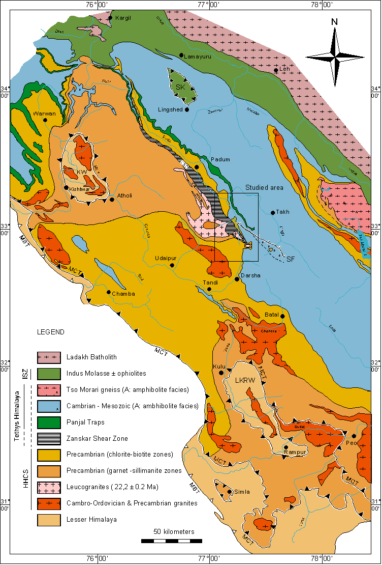
English: Tectonic map of the NW Himalaya.
Geological Map of the NW Himalaya, compiled after the work of:
|
| Date | |
| Source | Transferred from en.wikipedia to Commons. |
| Author | Original uploader was Moumine at en.wikipedia |
| Permission (Reusing this file) |
See below. This image comes from an online verson of the PhD thesis of Pierre Dèzes (1999; Institut de Mineralogie et Petrographie, Université de Lausanne). Dèzes gives permission for "Documents on this site can be used inasmuch as reference is clearly made to the above-mentioned publication and/or this website". |
Licensing edit

|
The copyright holder of this file, Pierre Dèzes, allows anyone to use it for any purpose, provided that the copyright holder is properly attributed. Redistribution, derivative work, commercial use, and all other use is permitted. |
Attribution:
PhD thesis of Pierre Dèzes 1999, "Tectonic and metamorphic Evolution of the Central Himalayan Domain in Southeast Zanskar (Kashmir, India)". Mémoires de Géologie (Lausanne) No. 32, ISSN 1015-3578 or the website: http://zanskar.geoheritage.ch
|
Original upload log edit
| date/time | username | resolution | size | edit summary |
|---|---|---|---|---|
| 21:42, 2 March 2005 | w:en:User:Moumine | 752×1,110 | 57 KB | tectonic map of the NW Himalaya |
Original upload log edit
| Date/Time | Dimensions | User | Comment |
|---|---|---|---|
| 25 February 2008, 19:36:54 | 752 × 1110 (58717 bytes) | BetacommandBot (talk · contribs) | Transwiki approved by: [[w:en:User:Multichill]] {{Information |Description={{en|tectonic map of the NW Himalaya This image comes from an [http://comp1.geol.unibas.ch/zanskar/ online verson] of the PhD thesis of Pierre Dèzes (1999; Institut de Mineral |
File history
Click on a date/time to view the file as it appeared at that time.
| Date/Time | Thumbnail | Dimensions | User | Comment | |
|---|---|---|---|---|---|
| current | 14:04, 23 July 2014 | | 752 × 1,110 (49 KB) | GifTagger (talk | contribs) | Bot: Converting file to superior PNG file. (Source: 2_6_tectomap2.gif). This GIF was problematic due to non-greyscale color table. |
You cannot overwrite this file.
File usage on Commons
The following page uses this file:
- File:2 6 tectomap2.gif (file redirect)
File usage on other wikis
The following other wikis use this file:
- Usage on en.wikipedia.org
- Usage on fr.wikipedia.org
- Usage on nl.wikipedia.org
- Usage on ru.wikipedia.org
- Usage on uk.wikipedia.org