File:365-371 Holderness Road, Hull - geograph.org.uk - 533939.jpg
No higher resolution available.
365-371_Holderness_Road,_Hull_-_geograph.org.uk_-_533939.jpg (640 × 353 pixels, file size: 75 KB, MIME type: image/jpeg)
Captions
Captions
Add a one-line explanation of what this file represents
Summary edit
| Description |
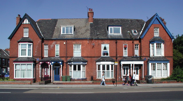
English: 365-371 Holderness Road, Hull A block of Victorian town houses designed by city architect Alfred Gelder (1854-1941), who later became Mayor of Hull. Alfred Gelder was presumably pleased with the resulting buildings as he is said to have lived at No.365 (left of picture) from 1888 to 1903. The house is now the offices of the rather wonderfully named Annison & Boddy Funeral Directors. Gelder was involved in the transformation of Queen's Dock into Queen's Gardens and designed a number of Methodist Chapels as well as a revolutionary roller flour mill for customers such as Joseph Rank.
Joseph Rank (1854-1943), fellow Methodist and founder of the milling firm of Joseph Rank Ltd., lived at No.371 (right of picture). His grandfather's old windmill still stands a little further along Holderness Road. https://www.geograph.org.uk/photo/214461 Joseph's son Joseph Arthur was born here in December 1888 but was to become famous for something other than the family business he inherited, although it continues to this day as Rank Hovis McDougall (RHM). Joseph Arthur began showing religious films as a Methodist minister in his middle age, an occupation which eventually led to him become a world-renowned film producer and distributor and founder of the Rank Organisation which is now known as The Rank Group Plc. |
| Date | |
| Source | From geograph.org.uk |
| Author | Paul Glazzard |
| Attribution (required by the license) | Paul Glazzard / 365-371 Holderness Road, Hull / |
| Camera location | | View this and other nearby images on: OpenStreetMap |
|---|
_heading:315.00&language=en)
| Object location | | View this and other nearby images on: OpenStreetMap |
|---|
_heading:315.00&language=en)
Licensing edit

|
This image was taken from the Geograph project collection. See this photograph's page on the Geograph website for the photographer's contact details. The copyright on this image is owned by Paul Glazzard and is licensed for reuse under the Creative Commons Attribution-ShareAlike 2.0 license.
|
This file is licensed under the Creative Commons Attribution-Share Alike 2.0 Generic license.
Attribution: Paul Glazzard
- You are free:
- to share – to copy, distribute and transmit the work
- to remix – to adapt the work
- Under the following conditions:
- attribution – You must give appropriate credit, provide a link to the license, and indicate if changes were made. You may do so in any reasonable manner, but not in any way that suggests the licensor endorses you or your use.
- share alike – If you remix, transform, or build upon the material, you must distribute your contributions under the same or compatible license as the original.
File history
Click on a date/time to view the file as it appeared at that time.
| Date/Time | Thumbnail | Dimensions | User | Comment | |
|---|---|---|---|---|---|
| current | 19:00, 5 February 2011 | | 640 × 353 (75 KB) | GeographBot (talk | contribs) | == {{int:filedesc}} == {{Information |description={{en|1=365-371 Holderness Road, Hull A block of Victorian town houses designed by city architect Alfred Gelder (1854-1941), who later became Mayor of Hull. Alfred Gelder was presumably pleased with the res |
You cannot overwrite this file.
File usage on Commons
There are no pages that use this file.
File usage on other wikis
The following other wikis use this file:
- Usage on www.wikidata.org