File:365 Crete Earthquake, Apollonia, Map (Jona).png

Size of this preview: 800 × 521 pixels. Other resolutions: 320 × 209 pixels | 640 × 417 pixels | 801 × 522 pixels.
Original file (801 × 522 pixels, file size: 12 KB, MIME type: image/png)
Captions
Captions
Add a one-line explanation of what this file represents
Summary edit
| Description |
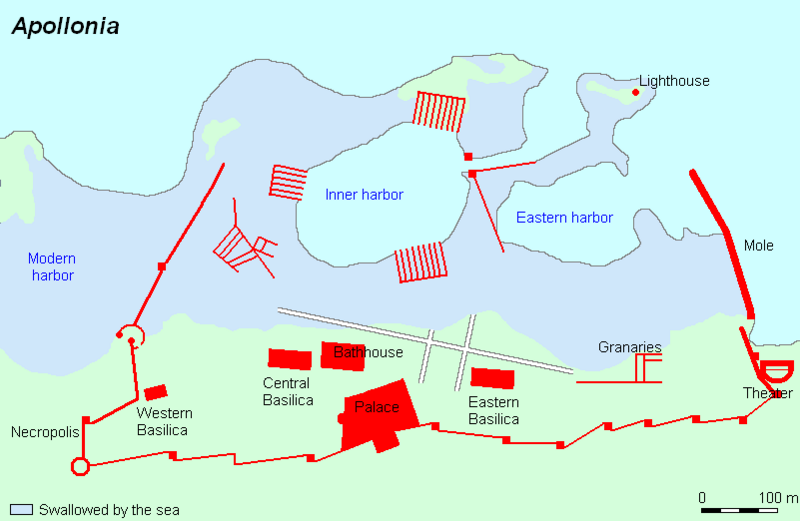
Deutsch: Stadplan des antiken Apollonia (Libyen). Apollonia wurde im 7. Jh. v. Chr. von griechischen Siedlern gegründet und diente als Hafen für das benachbarte Kyrene. Die Karte zeigt, welche Teile der Stadt nach dem Erdbeben von 365 n. Chr. im Meer versanken.
English: Map of ancient Apollonia, Libya. Apollonia was founded in the 7th century BC by Greek colonists and served as port of nearby Cyrene. The map shows which parts of the ancient city were submerged by the 365 AD Crete earthquake. |
||
| Date | |||
| Source | Livius.org: Apollonia (Susa) | ||
| Author | Jona Lendering | ||
| Permission (Reusing this file) |
|||
| Other versions |
|

.png&action=edit§ion=1)
Licensing edit
.png&action=edit§ion=2)
This file is licensed under the Creative Commons Attribution-Share Alike 3.0 Unported license.
- You are free:
- to share – to copy, distribute and transmit the work
- to remix – to adapt the work
- Under the following conditions:
- attribution – You must give appropriate credit, provide a link to the license, and indicate if changes were made. You may do so in any reasonable manner, but not in any way that suggests the licensor endorses you or your use.
- share alike – If you remix, transform, or build upon the material, you must distribute your contributions under the same or compatible license as the original.
Original upload log edit
.png&action=edit§ion=3)
| Date/Time | Dimensions | User | Comment |
|---|---|---|---|
| 22 February 2008, 18:07:15 | 801 × 522 (14438 bytes) | Gun Powder Ma (talk · contribs) | {{Information |Description= {{de|Stadplan des antiken Apollonia (Libyen). Apollonia wurde im 7. Jh. v. Chr. von griechischen Siedlern gegründet und dient als Hafen für das benachbarte Kyrene. Die Karte zeigt, welche Teile der Stadt nach dem Erdbeben von |
File history
Click on a date/time to view the file as it appeared at that time.
| Date/Time | Thumbnail | Dimensions | User | Comment | |
|---|---|---|---|---|---|
| current | 15:46, 23 July 2014 | | 801 × 522 (12 KB) | GifTagger (talk | contribs) | Bot: Converting file to superior PNG file. (Source: 365_Crete_Earthquake,_Apollonia,_Map_(Jona).gif). This GIF was problematic due to non-greyscale color table. |
.gif)
You cannot overwrite this file.
File usage on Commons
The following 4 pages use this file:
-pt.gif)
.gif&redirect=no)
File usage on other wikis
The following other wikis use this file:
- Usage on arz.wikipedia.org
- Usage on ca.wikipedia.org
- Usage on de.wikipedia.org
- Usage on el.wikipedia.org
- Usage on en.wikipedia.org
- Usage on es.wikipedia.org
- Usage on fi.wikipedia.org
- Usage on fr.wikipedia.org
- Usage on it.wikipedia.org
- Usage on ja.wikipedia.org
- Usage on nl.wikipedia.org
- Usage on no.wikipedia.org
- Usage on ru.wikipedia.org
- Usage on sl.wikipedia.org
- Usage on uk.wikipedia.org
- Usage on www.wikidata.org
.png&oldid=855547759)