File:42. — Lille. — Porte de Tournai.jpg

Size of this preview: 800 × 509 pixels. Other resolutions: 320 × 203 pixels | 640 × 407 pixels | 1,024 × 651 pixels | 1,280 × 814 pixels | 2,560 × 1,628 pixels | 3,265 × 2,076 pixels.
Original file (3,265 × 2,076 pixels, file size: 4.91 MB, MIME type: image/jpeg)
Captions
Captions
Add a one-line explanation of what this file represents
Summary edit
| Description |
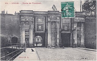
Français : Lille (France ) - département du Nord — La Porte de Tournai au début du XXe siècle. Celle-ci fut détruite en 1924 lors du démantèlement des fortifications de la Ville. Voir la situation de la porte de Tournai sur le plan de Lille réalisé en 1857 par J.-M. Darmet. → thumb|Portes de Fives et de Tournai. |
| Date | Postmark 1910 / cachet de la poste 1910. |
| Source | Collection personnelle |
| Author | Édition G.L. (Gorlier, éditeur à Lille (Nord) sous le sigle G. L. pendant la Belle Époque. S'associe à Cailteux après la Grande Guerre de 1914-1918. |
| See the following file for the recto-verso version of the postcard:
|
 |
| Camera location | | View this and other nearby images on: OpenStreetMap |
|---|
Licensing edit
|
This work is in the public domain in its country of origin and other countries and areas where the copyright term is the author's life plus 70 years or fewer. This work is in the public domain in the United States because it was published (or registered with the U.S. Copyright Office) before January 1, 1929. | |
| This file has been identified as being free of known restrictions under copyright law, including all related and neighboring rights. | |
File history
Click on a date/time to view the file as it appeared at that time.
| Date/Time | Thumbnail | Dimensions | User | Comment | |
|---|---|---|---|---|---|
| current | 08:43, 4 October 2020 | | 3,265 × 2,076 (4.91 MB) | Jpcuvelier (talk | contribs) | Uploaded a work by Édition G.L. (Gorlier, éditeur à Lille (Nord) sous le sigle G. L. pendant la Belle Époque. S'associe à Cailteux après la Grande Guerre de 1914-1918. from Collection personnelle with UploadWizard |
You cannot overwrite this file.
File usage on Commons
The following page uses this file: