File:476eur.jpg
No higher resolution available.
476eur.jpg (620 × 411 pixels, file size: 221 KB, MIME type: image/jpeg)
Captions
Captions
Add a one-line explanation of what this file represents
Summary edit
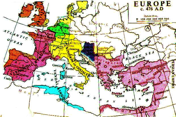
{{ew|en|Durova}] Europe in 476 AD, from Muir's Historical Atlas. (1911) Uploaded from Fordham University [1].
![[1]](http://www.fordham.edu/halsall/maps/476eur.jpg)
_en.png)
.png)
.jpg)
Licensing edit
This media file is in the public domain in the United States. This applies to U.S. works where the copyright has expired, often because its first publication occurred prior to January 1, 1929, and if not then due to lack of notice or renewal. See this page for further explanation.
|
 | |
 |
This image might not be in the public domain outside of the United States; this especially applies in the countries and areas that do not apply the rule of the shorter term for US works, such as Canada, Mainland China (not Hong Kong or Macao), Germany, Mexico, and Switzerland. The creator and year of publication are essential information and must be provided. See Wikipedia:Public domain and Wikipedia:Copyrights for more details.
|
File history
Click on a date/time to view the file as it appeared at that time.
| Date/Time | Thumbnail | Dimensions | User | Comment | |
|---|---|---|---|---|---|
| current | 16:09, 16 November 2022 | | 620 × 411 (221 KB) | Gyalu22 (talk | contribs) | I'm going blind |
| 13:21, 20 March 2017 |  | 620 × 411 (268 KB) | Julieta39 (talk | contribs) | contrast | |
| 14:04, 3 December 2006 |  | 620 × 411 (71 KB) | Electionworld (talk | contribs) | {{ew|en|Durova}] Europe in 476 AD, from ''Muir's Historical Atlas.'' (1911) Uploaded from Fordham University [http://www.fordham.edu/halsall/maps/476eur.jpg]. == Licensing == {{PD-US}} Category:Maps of the history of Europe |
You cannot overwrite this file.
File usage on Commons
The following 2 pages use this file:
File usage on other wikis
The following other wikis use this file:
- Usage on bg.wikipedia.org
- Usage on ca.wikipedia.org
- Usage on en.wikipedia.org
- Usage on eo.wikipedia.org
- Usage on es.wikipedia.org
- Usage on fr.wikipedia.org
- Usage on he.wikipedia.org
- Usage on hy.wikipedia.org
- Usage on it.wikipedia.org
- Usage on it.wikibooks.org
- Usage on nl.wikipedia.org
- Usage on pnb.wikipedia.org
- Usage on ru.wikipedia.org
- Usage on sr.wikipedia.org
- Usage on ta.wikipedia.org
- Usage on tr.wikipedia.org
- Usage on uk.wikipedia.org
- Usage on ur.wikipedia.org
- Usage on vi.wikipedia.org
- Usage on zh.wikipedia.org