File:64 Central Park Lots, New York City. - map by Muller, A. H. -1869 NYPL2015216.tiff

Size of this JPG preview of this TIF file: 735 × 600 pixels. Other resolutions: 294 × 240 pixels | 589 × 480 pixels | 942 × 768 pixels | 1,256 × 1,024 pixels | 2,511 × 2,048 pixels | 5,973 × 4,872 pixels.
Original file (5,973 × 4,872 pixels, file size: 83.29 MB, MIME type: image/tiff)
Captions
Captions
Add a one-line explanation of what this file represents
Summary edit
| Description | 64 Central Park Lots, New York City. / map by Muller, A. H. /1869; Maps of New York City and State / New York City / Manhattan | |||||||||||||||||||||||
| Date | Unknown date | |||||||||||||||||||||||
| Source |
http://digitalgallery.nypl.org/nypldigital/dgkeysearchdetail.cfm?imageID=2015216
|
|||||||||||||||||||||||
| Author | ||||||||||||||||||||||||
| Permission (Reusing this file) |
From The Lionel Pincus & Princess Firyal Map Division. http://maps.nypl.org
|
|||||||||||||||||||||||
| Location | Stephen A. Schwarzman Building / The Lionel Pincus and Princess Firyal Map Division | |||||||||||||||||||||||
| Digital item published | 1-12-2012 | |||||||||||||||||||||||
| Digital ID | 2015216 | |||||||||||||||||||||||

The making of this file was supported by Wikimedia UK.
To see other files made with the support of Wikimedia UK, please see the category Supported by Wikimedia UK.
|
File history
Click on a date/time to view the file as it appeared at that time.
| Date/Time | Thumbnail | Dimensions | User | Comment | |
|---|---|---|---|---|---|
| current | 06:41, 20 April 2014 | 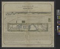 | 5,973 × 4,872 (83.29 MB) | Fæ (talk | contribs) | GWToolset:: Creating mediafile for Fæ. Tranche 2.210 |
You cannot overwrite this file.
File usage on Commons
There are no pages that use this file.