File:70th Tank Battalion Combat Operations Campaign Map for North Africa Sicily and Europe 1942-1945.jpg
Size of this preview: 773 × 599 pixels. Other resolutions: 310 × 240 pixels | 619 × 480 pixels | 991 × 768 pixels | 1,280 × 993 pixels | 2,560 × 1,985 pixels | 4,283 × 3,321 pixels.
Original file (4,283 × 3,321 pixels, file size: 819 KB, MIME type: image/jpeg)
Captions
Captions
Add a one-line explanation of what this file represents
Summary
edit
| Description |
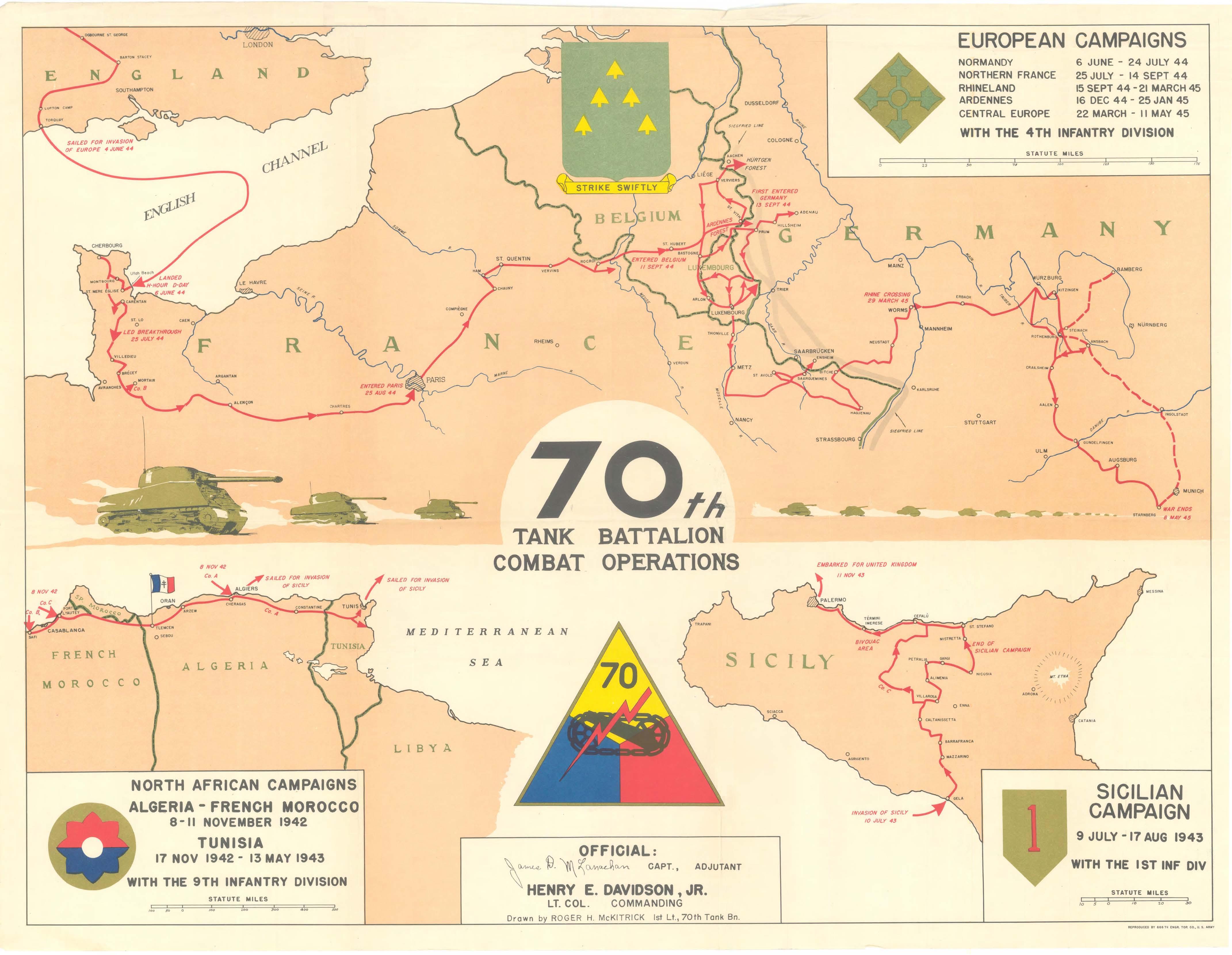
English: Map showing the locations where the elements of the 70th Tank Battalion fought in North Africa, Sicily, France, Belgium, Luxembourg, and Germany during World War II from November 1942 to May 1945. Map is included as part of the 70th Tank Battalion After Action Report (AAR). |
| Date | |
| Source | Combined Arms Research Library Digital Collection, Fort Leavenworth, KS |
| Author | 666th Engineer Topographic Company |
Located at http://cgsc.cdmhost.com/cdm/singleitem/collection/p4013coll8/id/3648/rec/18 archive copy at the Wayback Machine
Licensing
edit
This work is in the public domain in the United States because it is a work prepared by an officer or employee of the United States Government as part of that person’s official duties under the terms of Title 17, Chapter 1, Section 105 of the US Code.
Note: This only applies to original works of the Federal Government and not to the work of any individual U.S. state, territory, commonwealth, county, municipality, or any other subdivision. This template also does not apply to postage stamp designs published by the United States Postal Service since 1978. (See § 313.6(C)(1) of Compendium of U.S. Copyright Office Practices). It also does not apply to certain US coins; see The US Mint Terms of Use.
|
 | |
| This file has been identified as being free of known restrictions under copyright law, including all related and neighboring rights. | ||
File history
Click on a date/time to view the file as it appeared at that time.
| Date/Time | Thumbnail | Dimensions | User | Comment | |
|---|---|---|---|---|---|
| current | 20:24, 17 April 2012 | | 4,283 × 3,321 (819 KB) | Bilhartz (talk | contribs) |
You cannot overwrite this file.
File usage on Commons
There are no pages that use this file.
File usage on other wikis
The following other wikis use this file:
- Usage on en.wikipedia.org