File:7 Sup Hol 1573 Sgrooten.jpg

Size of this preview: 672 × 599 pixels. Other resolutions: 269 × 240 pixels | 538 × 480 pixels | 861 × 768 pixels | 1,148 × 1,024 pixels | 1,971 × 1,758 pixels.
Original file (1,971 × 1,758 pixels, file size: 2.94 MB, MIME type: image/jpeg)
Captions
Captions
Add a one-line explanation of what this file represents
Summary edit
| Description |
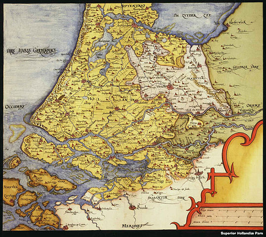
Nederlands: Handgetekende kaart van Zuid-Holland; Utrecht
English: Detail of a 16th-century map showing South Holland and the Prince-Bishopric of Utrecht ("Episcopatus Traiecten", in white), more precisely the part of the Prince-Bishopric known as Nedersticht Utrecht (Lower Utrecht) centered on the city of Utrecht ("Vtrycht"). |
| Date | |
| Source | KBR Brusselse Atlas; 9 gemonteerde downloads |
| Author | Sgrooten, Christiaan |
| Other versions | Zwart-wit repro; Archieven.nl: 2e plaatje |
Zuid-Holland; Utrecht
Licensing edit
|
This work is in the public domain in its country of origin and other countries and areas where the copyright term is the author's life plus 100 years or fewer. | |
| This file has been identified as being free of known restrictions under copyright law, including all related and neighboring rights. | |
File history
Click on a date/time to view the file as it appeared at that time.
| Date/Time | Thumbnail | Dimensions | User | Comment | |
|---|---|---|---|---|---|
| current | 08:31, 27 July 2010 | | 1,971 × 1,758 (2.94 MB) | Joopr (talk | contribs) | {{Information |Description={{nl|1=Handgetekende kaart van Zuid-Holland; Utrecht}} |Source=http://mara.kbr.be/kbrImage/maps/1678141_3.imgf KBR Brusselse Atlas |Author=Sgrooten, Christiaan |Date=1573 |Permission= |other_versions=[[http://www.archieven.n |
You cannot overwrite this file.
File usage on Commons
The following page uses this file:
File usage on other wikis
The following other wikis use this file:
- Usage on fr.wikipedia.org
- Usage on nl.wikipedia.org