File:9nations.png
No higher resolution available.
9nations.png (619 × 456 pixels, file size: 44 KB, MIME type: image/png)
Captions
Captions
Add a one-line explanation of what this file represents
Summary edit
| Description |
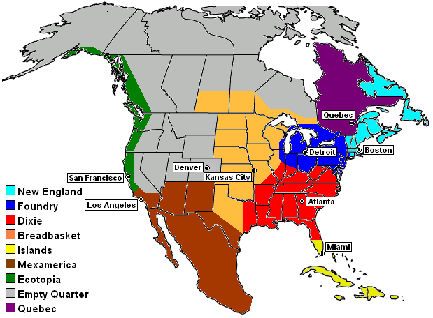
Map of the en:Nine Nations of North America, as defined by en:Joel Garreau, showing capitals. The drawing of the Nine Nation regions are based on a combination of sources, including:
Credit: KeithTyler Base outline map provided by WorldAtlas.com at [1], which includes a statement that outline maps do not need permission for use or reuse. |
| Date | 4 November 2004 (original upload date) |
| Source | Transferred from en.wikipedia to Commons. |
| Author |
The original uploader was KeithTyler at English Wikipedia. Later versions were uploaded by Cumbiadude, Habsfannova at en.wikipedia. |

|
This fictional map image could be re-created using vector graphics as an SVG file. This has several advantages; see Commons:Media for cleanup for more information. If an SVG form of this image is available, please upload it and afterwards replace this template with
{{vector version available|new image name}}.
It is recommended to name the SVG file “9nations.svg”—then the template Vector version available (or Vva) does not need the new image name parameter. |
Licensing edit
| This file is licensed under the Creative Commons Attribution-Share Alike 3.0 Unported license. Subject to disclaimers. | ||
| ||
| This licensing tag was added to this file as part of the GFDL licensing update. |

|
Permission is granted to copy, distribute and/or modify this document under the terms of the GNU Free Documentation License, Version 1.2 or any later version published by the Free Software Foundation; with no Invariant Sections, no Front-Cover Texts, and no Back-Cover Texts. A copy of the license is included in the section entitled GNU Free Documentation License. Subject to disclaimers. |
Original upload log edit
The original description page was here. All following user names refer to en.wikipedia.
- 2005-10-15 16:11 Habsfannova 619×456×8 (45277 bytes) 9nations.png (45KB, MIME type: image/png) Map of the Nine Nations of North America, as defined by Joel Garreau, showing capitals. The drawing of the Nine Nation regions are based on a combination of sources, including: * Descriptions at Nine Nation
- 2005-08-06 21:56 Cumbiadude 619×456×8 (45389 bytes) fixed teal spot at top of map (made it white like the rest)
- 2004-11-04 01:32 KeithTyler 619×456×8 (64346 bytes) Nine Nations of North America
File history
Click on a date/time to view the file as it appeared at that time.
| Date/Time | Thumbnail | Dimensions | User | Comment | |
|---|---|---|---|---|---|
| current | 15:58, 22 May 2007 | | 619 × 456 (44 KB) | Liftarn (talk | contribs) | {{Information |Description=Map of the en:Nine Nations of North America, as defined by en:Joel Garreau, showing capitals. The drawing of the Nine Nation regions are based on a combination of sources, including: *Descriptions at [[:en:Nine Natio |
You cannot overwrite this file.
File usage on Commons
There are no pages that use this file.