File:AMH-2478-NA Fort of Good Hope, waterfront perspective.jpg
Original file (2,400 × 1,774 pixels, file size: 632 KB, MIME type: image/jpeg)
Captions
Captions
Summary edit
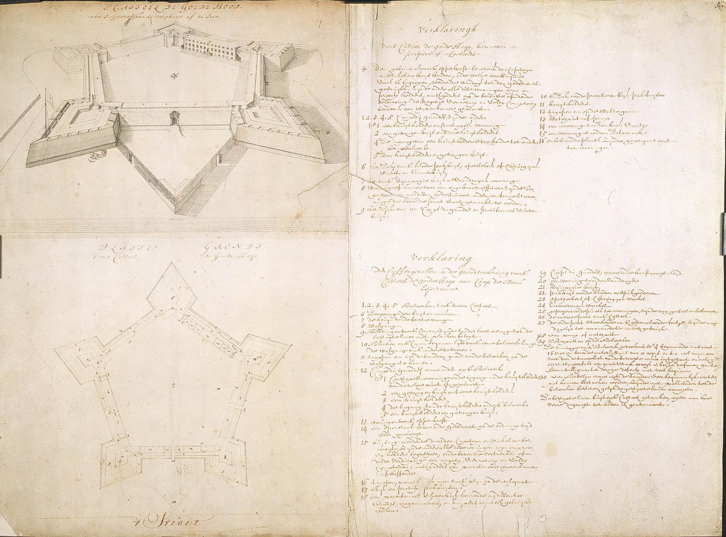
Nederlands: Kasteel de Goede Hoop, in perspectief vanaf de waterkant
English: Fort of Good Hope, waterfront perspective( |
||||||||||||||||||||||||||
|---|---|---|---|---|---|---|---|---|---|---|---|---|---|---|---|---|---|---|---|---|---|---|---|---|---|---|
| Author |
Nederlands: Isaac de Graaff (landmeter / kaartenmaker), Jan Wittebol (landmeter / kaartenmaker)
English: Isaac de Graaff (land surveyor / mapmaker), Jan Wittebol (land surveyor / mapmaker) |
|||||||||||||||||||||||||
| Title |
Nederlands: Kasteel de Goede Hoop, in perspectief vanaf de waterkant
English: Fort of Good Hope, waterfront perspective |
|||||||||||||||||||||||||
| Description |
Nederlands: Titel catalogus Leupe (NA): 'T Casteel de Goede Hoop, in het perspectief van de waterkant af te sien.
Inzetkaart boven: Verklaring van 't Casteel de Goede Hoop, hiernevens in perspectief afgebeeldt. Legenda: 1-9; 1-30 Inzetkaart onder: Platte grondt van 't Casteel de Goede Hoop. Notities verso: A. A. nr. 5 d. verso nr. 498 ij.. Gerestaureerd op linnen.English: The original title according to the catalogue Leupe (NA) is: 'T Casteel de Goede Hoop, in het perspectief van de waterkant af te sien.
Upper insert: Verklaring van 't Casteel de Goede Hoop, hiernevens in perspectief afgebeeldt. Key: 1-9; 1-30 Lower insert: Platte grondt van 't Casteel de Goede Hoop. Notes on reverse: A. A. nr. 5 d. verso nr. 498 ij.. Restored on linen. |
|||||||||||||||||||||||||
| Date | between 1690 and 1743 | |||||||||||||||||||||||||
| Medium |
Nederlands: pen en penseel op papier / linnen
English: pen and brush on paper / linen |
|||||||||||||||||||||||||
| Dimensions | height: 355 mm (13.97 in); width: 230 mm (9.05 in) | |||||||||||||||||||||||||
| Collection |
|
|||||||||||||||||||||||||
| Accession number |
NL-HaNA_4.VEL_830 (old number: VEL0830) |
|||||||||||||||||||||||||
| Inscriptions |
't Casteel de Goede Hoop, in het perspectief van de waterkant af te sien.
author: Wittebol |
|||||||||||||||||||||||||
| Notes |
English: Subjects: chart / map / plan, survey / view, fortification, building, warehouse, prison, key
Nederlands: Onderwerpen: plattegrond / kaart, overzicht / aanzicht, vesting, gebouw, pakhuis, gevangenis, legenda
English: Fort: this image is related to a VOC fort called kasteel de Goede Hoop |
|||||||||||||||||||||||||
| Source/Photographer |
|
|||||||||||||||||||||||||
| Permission (Reusing this file) |
|
|||||||||||||||||||||||||

| Object location | | View this and other nearby images on: OpenStreetMap |
|---|
File history
Click on a date/time to view the file as it appeared at that time.
| Date/Time | Thumbnail | Dimensions | User | Comment | |
|---|---|---|---|---|---|
| current | 11:16, 20 May 2014 | | 2,400 × 1,774 (632 KB) | HuskyBot (talk | contribs) | == {{int:filedesc}} == {{Artwork |title = {{nl|Kasteel de Goede Hoop, in perspectief vanaf de waterkant}} {{en|Fort of Good Hope, waterfront perspective}} |description = {{nl|Titel catalogus Leupe (NA): <'T... |
You cannot overwrite this file.
File usage on Commons
The following page uses this file:
File usage on other wikis
The following other wikis use this file:
- Usage on nl.wikipedia.org