File:AMH-2521-NA Chart of the northern coast of the island of Formosa and Kelangh.jpg

Original file (2,400 × 1,686 pixels, file size: 652 KB, MIME type: image/jpeg)
Captions
Captions
Summary edit
Nederlands: Kaart van de noordkust van het eiland Formosa en Kelangh
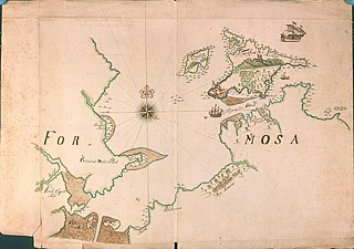
English: Chart of the northern coast of the island of Formosa and Kelangh( |
||||||||||||||||||||||||
|---|---|---|---|---|---|---|---|---|---|---|---|---|---|---|---|---|---|---|---|---|---|---|---|---|
| Author |
Creator:Cornelis Vischer/Vischbee Nederlands: Cornelis Vischer/Vischbee (toegeschreven aan landmeter/kaartenmaker)
English: Cornelis Vischer/Vischbee (assigned to land surveyor / mapmaker) |
|||||||||||||||||||||||
| Title |
Nederlands: Kaart van de noordkust van het eiland Formosa en Kelangh
English: Chart of the northern coast of the island of Formosa and Kelangh |
|||||||||||||||||||||||
| Description |
Nederlands: Titel catalogus Leupe (NA): Kaart van de Noordkust van het Eiland Formosa met het Eiland Kelang.
Zie ook VELH129. Notities verso: Formosa noordhoeck, en 't eyl:t Kelangh, en desselfs haven, No 22. Op het eiland Kelangh zijn twee Hollandse fortificaties zichtbaar. Toegeschreven aan Cornelis Visscher, zie NA, inhoudsopgave OBP of aantekeningen catalogus Leupe.English: According to the Leupe catalogue (NA) the original title reads: Kaart van de Noordkust van het Eiland Formosa met het Eiland Kelang.
Refer also to VELH129. Notes on reverse: Formosa noordhoeck, en 't eyl:t Kelangh, en desselfs haven, No 22. Two Dutch forts are visible on the island of Kelangh. Attributed to Cornelis Visscher; see NA, contents OBP or notes Leupe catalogue. |
|||||||||||||||||||||||
| Date | circa 1667 | |||||||||||||||||||||||
| Medium |
Nederlands: ingekleurde tekening op papier
English: coloured drawing on paper |
|||||||||||||||||||||||
| Dimensions | height: 690 mm (27.16 in); width: 485 mm (19.09 in) | |||||||||||||||||||||||
| Collection |
|
|||||||||||||||||||||||
| Accession number |
NL-HaNA_4.VEL_307 (old number: VEL0307) |
|||||||||||||||||||||||
| Inscriptions |
Formosa
|
|||||||||||||||||||||||
| Notes |
English: Subjects: chart / map / plan, bird's-eye view / elevation, elevation / bird's-eye view, fortification, building, ship / vessel, estate / plantation, compass / dial
Nederlands: Onderwerpen: plattegrond / kaart, vogelvlucht / opstand, opstand / vogelvlucht, vesting, gebouw, schip / vaartuig, landerij / plantage, kompas / windroos
English: Post: this image is related to a VOC trading post called Chi-lung |
|||||||||||||||||||||||
| Source/Photographer |
|
|||||||||||||||||||||||
| Permission (Reusing this file) |
|
|||||||||||||||||||||||

| Object location | | View this and other nearby images on: OpenStreetMap |
|---|
[[Category:Maps of the Dutch East India Company - Taiwan|1667]
File history
Click on a date/time to view the file as it appeared at that time.
| Date/Time | Thumbnail | Dimensions | User | Comment | |
|---|---|---|---|---|---|
| current | 15:50, 10 June 2014 | | 2,400 × 1,686 (652 KB) | HuskyBot (talk | contribs) | == {{int:filedesc}} == {{Artwork |title = {{nl|1=Kaart van de noordkust van het eiland Formosa en Kelangh}} {{en|1=Chart of the northern coast of the island of Formosa and Kelangh}} |description = {{nl|1=Titel... |
You cannot overwrite this file.
File usage on Commons
The following page uses this file: