File:AMH-2584-NA Map of the fort at Cananoor.jpg

Original file (2,400 × 1,674 pixels, file size: 571 KB, MIME type: image/jpeg)
Captions
Captions
Summary edit
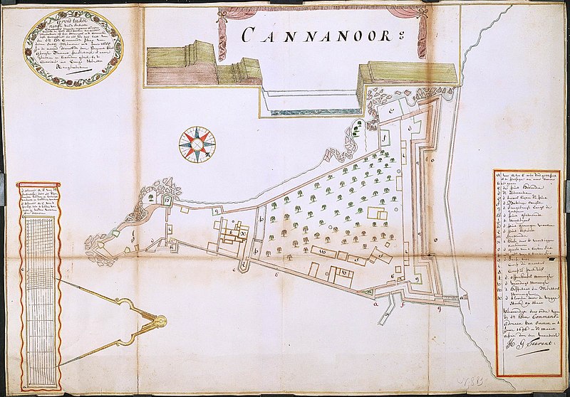
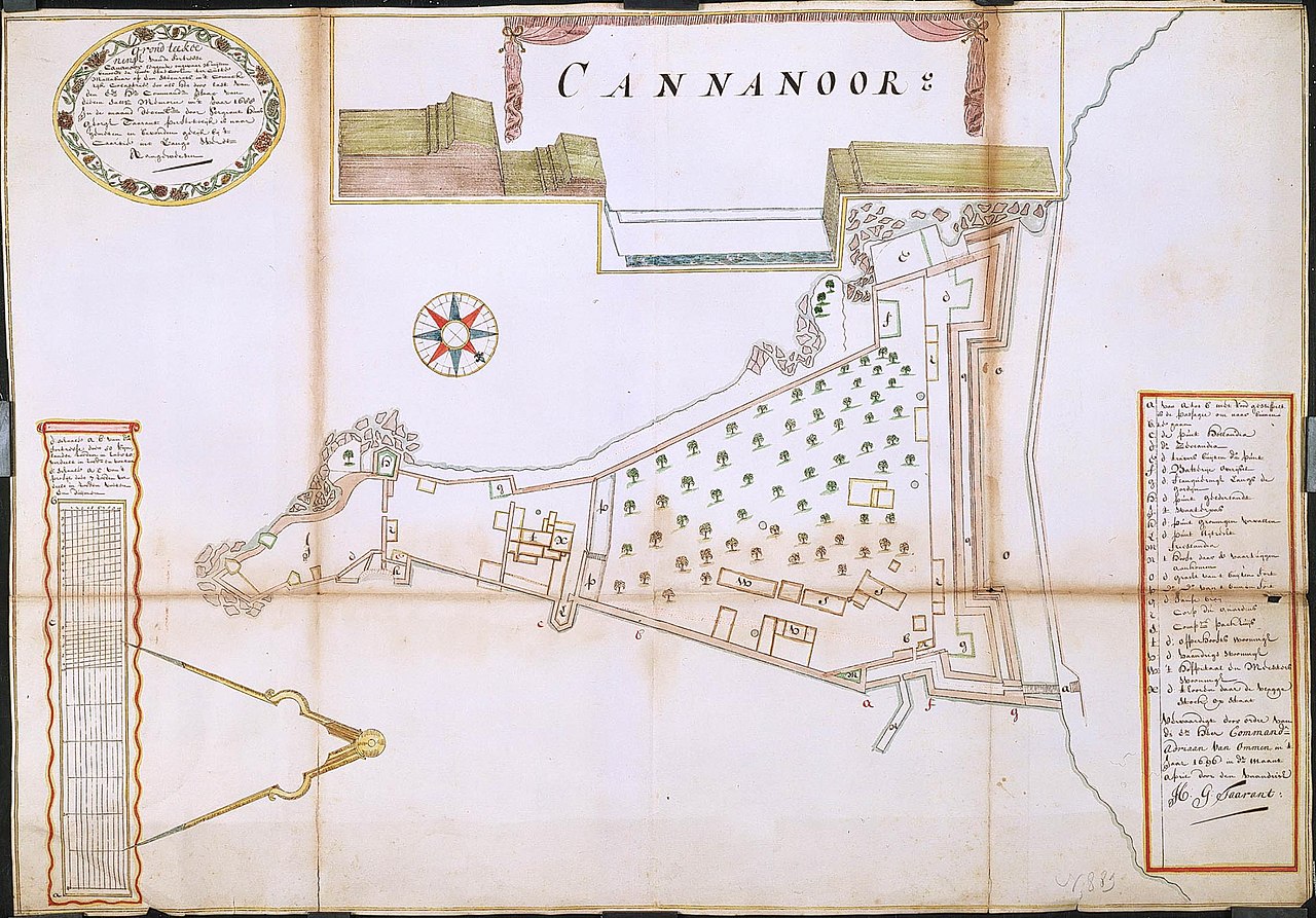
Nederlands: Plattegrond van het fort van Cananoor
English: Map of the fort at Cananoor( |
||||||||||||||||||||||||
|---|---|---|---|---|---|---|---|---|---|---|---|---|---|---|---|---|---|---|---|---|---|---|---|---|
| Author |
Creator:Hans Georg Taarant/Tarand Creator:Adriaan van Ommen Nederlands: Hans Georg Taarant/Tarand (landmeter / kaartenmaker), Adriaan van Ommen (opdrachtgever)
English: Hans Georg Taarant/Tarand (land surveyor / mapmaker), Adriaan van Ommen (patron) |
|||||||||||||||||||||||
| Title |
Nederlands: Plattegrond van het fort van Cananoor
English: Map of the fort at Cananoor |
|||||||||||||||||||||||
| Description |
Nederlands: Titel catalogus Leupe (NA): Grondteekening van de Fortresse Cananoor, leggende ongeveer 36 mylen benoorden de Hoofdstad Cochim, ter Custe Malabaar op een Steenrots enz..
Jaartal overgekomen Brieven en Papieren: 1703 Legenda: a-x Plattegrond en profieltekening van de vestingwerken van het fort Cannanoor. Notities verso: nr. 499 1 [of e?]. Topografische namen op deze kaart vermeld: Mallabaar, punt Hollandia, punt Zeelandia, punt Gelderlandt, punt Uijtreght, punt Frieslandia, batterije Overijsel, punt Groningen.English: According to catalogue Leupe (NA), the original title reads: Grondteekening van de Fortresse Cananoor, leggende ongeveer 36 mylen benoorden de Hoofdstad Cochim, ter Custe Malabaar op een Steenrots enz..
Date of the letters and papers brought over is 1703 Key: a-x Ground plan and elevation of the fortifications of the fort at Cannanoor. Notes on reverse: nr. 499 1 [or e?]. Topographical names mentioned on the map: Mallabaar, punt Hollandia, punt Zeelandia, punt Gelderlandt, punt Uijtreght, punt Frieslandia, batterije Overijsel, punt Groningen. |
|||||||||||||||||||||||
| Date | 1 April 1696 | |||||||||||||||||||||||
| Medium |
Nederlands: ingekleurde tekening op papier
English: coloured drawing on paper |
|||||||||||||||||||||||
| Dimensions | height: 73 cm (28.7 in); width: 52 cm (20.4 in) | |||||||||||||||||||||||
| Collection |
|
|||||||||||||||||||||||
| Accession number |
NL-HaNA_4.VEL_889 (old number: VEL0889) |
|||||||||||||||||||||||
| Inscriptions |
Grond teekceninge: van de Fortresse Cananoor leggende ongevaar 36 mylen benoorde de hoofdt stad Cochim ter Custe Mallabaar, [...]
author: H.G. Taarant |
|||||||||||||||||||||||
| Notes |
English: Subjects: chart / map / plan, fortification, hospital / lazaret, anchorage / pier / harbour, cross-section / profile, banderole / cartouche / ornamentation, key, compass / dial
Nederlands: Onderwerpen: plattegrond / kaart, vesting, ziekenhuis / lazaret, rede / haven / pier, doorsnede / profiel, banderol / cartouche / versiering, legenda, kompas / windroos
English: Post: this image is related to a VOC trading post called Cannanore |
|||||||||||||||||||||||
| Source/Photographer |
|
|||||||||||||||||||||||
| Permission (Reusing this file) |
|
|||||||||||||||||||||||

| Object location | | View this and other nearby images on: OpenStreetMap |
|---|
File history
Click on a date/time to view the file as it appeared at that time.
| Date/Time | Thumbnail | Dimensions | User | Comment | |
|---|---|---|---|---|---|
| current | 16:01, 10 June 2014 | | 2,400 × 1,674 (571 KB) | HuskyBot (talk | contribs) | == {{int:filedesc}} == {{Artwork |title = {{nl|1=Plattegrond van het fort van Cananoor}} {{en|1=Map of the fort at Cananoor}} |description = {{nl|1=Titel catalogus Leupe (NA): ''Grondteekening van de Fortresse... |
You cannot overwrite this file.
File usage on Commons
The following page uses this file:
File usage on other wikis
The following other wikis use this file:
- Usage on nl.wikipedia.org