File:AMH-2624-NA Map of the castle and suburbs of Colombo.jpg

Original file (2,400 × 1,041 pixels, file size: 447 KB, MIME type: image/jpeg)
Captions
Captions
Summary edit
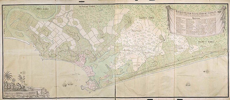
Nederlands: Plattegrond van het kasteel en de voorstad van Colombo
English: Map of the castle and suburbs of Colombo( |
||||||||||||||||||||||||
|---|---|---|---|---|---|---|---|---|---|---|---|---|---|---|---|---|---|---|---|---|---|---|---|---|
| Author |
Nederlands: Carel David Wentzel (landmeter / kaartenmaker)
English: Carel David Wentzel (land surveyor / mapmaker) |
|||||||||||||||||||||||
| Title |
Nederlands: Plattegrond van het kasteel en de voorstad van Colombo
English: Map of the castle and suburbs of Colombo |
|||||||||||||||||||||||
| Description |
Nederlands: Titel catalogus Leupe: Plan en Caart van de situatie buyten het Casteel, de voorstad en gravetten van Colombo, met alle de wateren, weegen, hoogtens, thuynen en saayvelden enz..
Legenda: a-z; 1-19 Kaart van de stad Colombo en omgeving van de riviermond van de Kellingange in het noorden tot de rivier Kallibouille in het zuiden. Cartouche met een olifant en drie inheemse personen waarvan de middelste met een pajong. Opmerking catalogus Leupe: Gravetten zijn afsluitingen. Notities verso: Blauw etiket ODG nr. 17 Plan en situatie van het kasteel en stad Colombo; Gedrukt etiket nr. 524. VEL0953 bestaat uit twee ectachromen: links en rechts. Topografische namen vermeld op deze kaart: Salpitti Corle, Marandaan, Coelbitty, Wellewatte, Hinna Corle, Hewegam Corle, Aloetcoer Corle.English: The original title according to the catalogue Leupe (NA) reads: Plan en Caart van de situatie buyten het Casteel, de voorstad en gravetten van Colombo, met alle de wateren, weegen, hoogtens, thuynen en saayvelden enz..
Key: a-z; 1-19 City plan of Colombo and surrounding land near the Kellingange river mount in the north and in the south the river Kallibouille. Cartouche with an elephant and three indigenous people, the person in the middle is holding a pNAsol. Additional comments catalogue Leupe (NA): Gravetten zijn afsluitingen. Notes on reverse: Blauw etiket ODG nr. 17 Plan en situatie van het kasteel en stad Colombo; Gedrukt etiket nr. 524. VEL0953 exists of two ectachromes: left and right. Topographical names mentioned on this map are: Salpitti Corle, Marandaan, Coelbitty, Wellewatte, Hinna Corle, Hewegam Corle, Aloetcoer Corle. |
|||||||||||||||||||||||
| Date | circa 1762 | |||||||||||||||||||||||
| Medium |
Nederlands: ingekleurde tekening op papier
English: coloured drawing on paper |
|||||||||||||||||||||||
| Dimensions | height: 144 cm (56.6 in); width: 83 cm (32.6 in) | |||||||||||||||||||||||
| Collection |
|
|||||||||||||||||||||||
| Accession number |
NL-HaNA_4.VEL_953 (old number: VEL0953) |
|||||||||||||||||||||||
| Inscriptions |
Plan en Caart van de situatie buyten het Casteel, de voorstad en gravetten van Colombo, met alle de Waateren, Weegen, Hoogtens, Thuynen en Saayvelden seijnde de stranden met Ebbe in de drooge maanden Februarij en Maart opgenoomen. author: Carel David Wentzel |
|||||||||||||||||||||||
| Notes |
English: Subjects: chart / map / plan, church / parsonage, fortification, hospital / lazaret, ship / vessel, garden / ornamental garden, Asians & Africans, warehouse, banderole / cartouche / ornamentation, key, compass / dial
Nederlands: Onderwerpen: plattegrond / kaart, kerk / pastorie, vesting, ziekenhuis / lazaret, schip / vaartuig, tuin / siertuin, Aziaten & Afrikanen, pakhuis, banderol / cartouche / versiering, legenda, kompas / windroos
English: Post: this image is related to a VOC trading post called Colombo |
|||||||||||||||||||||||
| Source/Photographer |
|
|||||||||||||||||||||||
| Permission (Reusing this file) |
|
|||||||||||||||||||||||

| Object location | | View this and other nearby images on: OpenStreetMap |
|---|
File history
Click on a date/time to view the file as it appeared at that time.
| Date/Time | Thumbnail | Dimensions | User | Comment | |
|---|---|---|---|---|---|
| current | 16:10, 10 June 2014 | | 2,400 × 1,041 (447 KB) | HuskyBot (talk | contribs) | == {{int:filedesc}} == {{Artwork |title = {{nl|1=Plattegrond van het kasteel en de voorstad van Colombo}} {{en|1=Map of the castle and suburbs of Colombo}} |description = {{nl|1=Titel catalogus Leupe: ''Plan en... |
You cannot overwrite this file.
File usage on Commons
The following page uses this file:
File usage on other wikis
The following other wikis use this file:
- Usage on nl.wikipedia.org