File:AMH-2633-NA Map of the fort at Cochin.jpg

Size of this preview: 800 × 513 pixels. Other resolutions: 320 × 205 pixels | 640 × 410 pixels | 1,024 × 657 pixels | 1,280 × 821 pixels | 2,400 × 1,539 pixels.
Original file (2,400 × 1,539 pixels, file size: 719 KB, MIME type: image/jpeg)
Captions
Captions
Add a one-line explanation of what this file represents
Summary edit
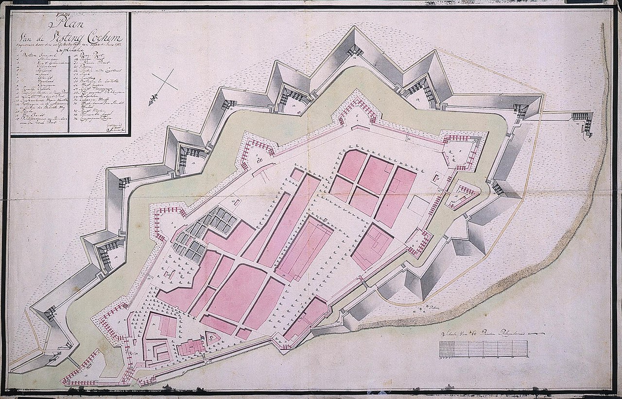
Nederlands: Plattegrond van de vesting Cochin
English: Map of the fort at Cochin( |
||||||||||||||||||||||||
|---|---|---|---|---|---|---|---|---|---|---|---|---|---|---|---|---|---|---|---|---|---|---|---|---|
| Author |
Creator:G.E. Schenk Creator:Carl von Krauv Nederlands: G.E. Schenk (landmeter / kaartenmaker), Carl von Krauv (landmeter / kaartenmaker)
English: G.E. Schenk (land surveyor / mapmaker), Carl von Krauv (land surveyor / mapmaker) |
|||||||||||||||||||||||
| Title |
Nederlands: Plattegrond van de vesting Cochin
English: Map of the fort at Cochin |
|||||||||||||||||||||||
| Description |
Nederlands: Titel catalogus Leupe (NA): Plan van de Vesting Cochim, opgenomen door den landmeter Carl von Krause, 1782.
Behoort bij de rapporten van de militaire commissie naar de Oost 1789-1792, o.l.v. J.O. Vaillant, C.A. Verhuell en J.F.L. van Gravenstein. Zie NA Staatssecretarie inv. nr. 1910-1932; Collectie Verhuell nrs. 7-45.
English: According to the Leupe catalogue (NA) the original title reads: Plan van de Vesting Cochim, opgenomen door den landmeter Carl von Krause, 1782.
It belongs with the reports of the military commission to the East 1789-1792 led by J.O. Vaillant, C.A. Verhuell en J.F.L. van Gravenstein. See NA Staatssecretarie inv. nr. 1910-1932; Collectie Verhuell nrs. 7-45. |
|||||||||||||||||||||||
| Date | 1782 | |||||||||||||||||||||||
| Medium |
Nederlands: ingekleurde tekening op papier
English: coloured drawing on paper |
|||||||||||||||||||||||
| Dimensions | height: 76 cm (29.9 in); width: 49 cm (19.2 in) | |||||||||||||||||||||||
| Collection |
|
|||||||||||||||||||||||
| Accession number |
NL-HaNA_4.VEL_905 (old number: VEL0905) |
|||||||||||||||||||||||
| Inscriptions |
Plan van de Vesting Cochim, opgenomen door de landmeter Carl von Krauv
author: Schenk / Carl von Krause |
|||||||||||||||||||||||
| Notes |
English: Subjects: chart / map / plan, fortification, key, banderole / cartouche / ornamentation
Nederlands: Onderwerpen: plattegrond / kaart, vesting, legenda, banderol / cartouche / versiering
English: Post: this image is related to a VOC trading post called Cochin |
|||||||||||||||||||||||
| Source/Photographer |
|
|||||||||||||||||||||||
| Permission (Reusing this file) |
|
|||||||||||||||||||||||

| Object location | | View this and other nearby images on: OpenStreetMap |
|---|
File history
Click on a date/time to view the file as it appeared at that time.
| Date/Time | Thumbnail | Dimensions | User | Comment | |
|---|---|---|---|---|---|
| current | 16:12, 10 June 2014 | | 2,400 × 1,539 (719 KB) | HuskyBot (talk | contribs) | == {{int:filedesc}} == {{Artwork |title = {{nl|1=Plattegrond van de vesting Cochin}} {{en|1=Map of the fort at Cochin}} |description = {{nl|1=Titel catalogus Leupe (NA): ''Plan van de Vesting Cochim, opgenomen... |
You cannot overwrite this file.
File usage on Commons
The following page uses this file: