File:AMH-4534-NA Maps of Baticaloa and Kalture.jpg
Original file (2,400 × 1,703 pixels, file size: 644 KB, MIME type: image/jpeg)
Captions
Captions
Summary
editNederlands: Plattegronden van Baticaloa en Kalture
English: Maps of Baticaloa and Kalture( |
||||||||||||||||||||||||||
|---|---|---|---|---|---|---|---|---|---|---|---|---|---|---|---|---|---|---|---|---|---|---|---|---|---|---|
| Author |
Nederlands: Isaac de Graaff (landmeter / kaartenmaker)
English: Isaac de Graaff (land surveyor / mapmaker) |
|||||||||||||||||||||||||
| Title |
Nederlands: Plattegronden van Baticaloa en Kalture
English: Maps of Baticaloa and Kalture |
|||||||||||||||||||||||||
| Description |
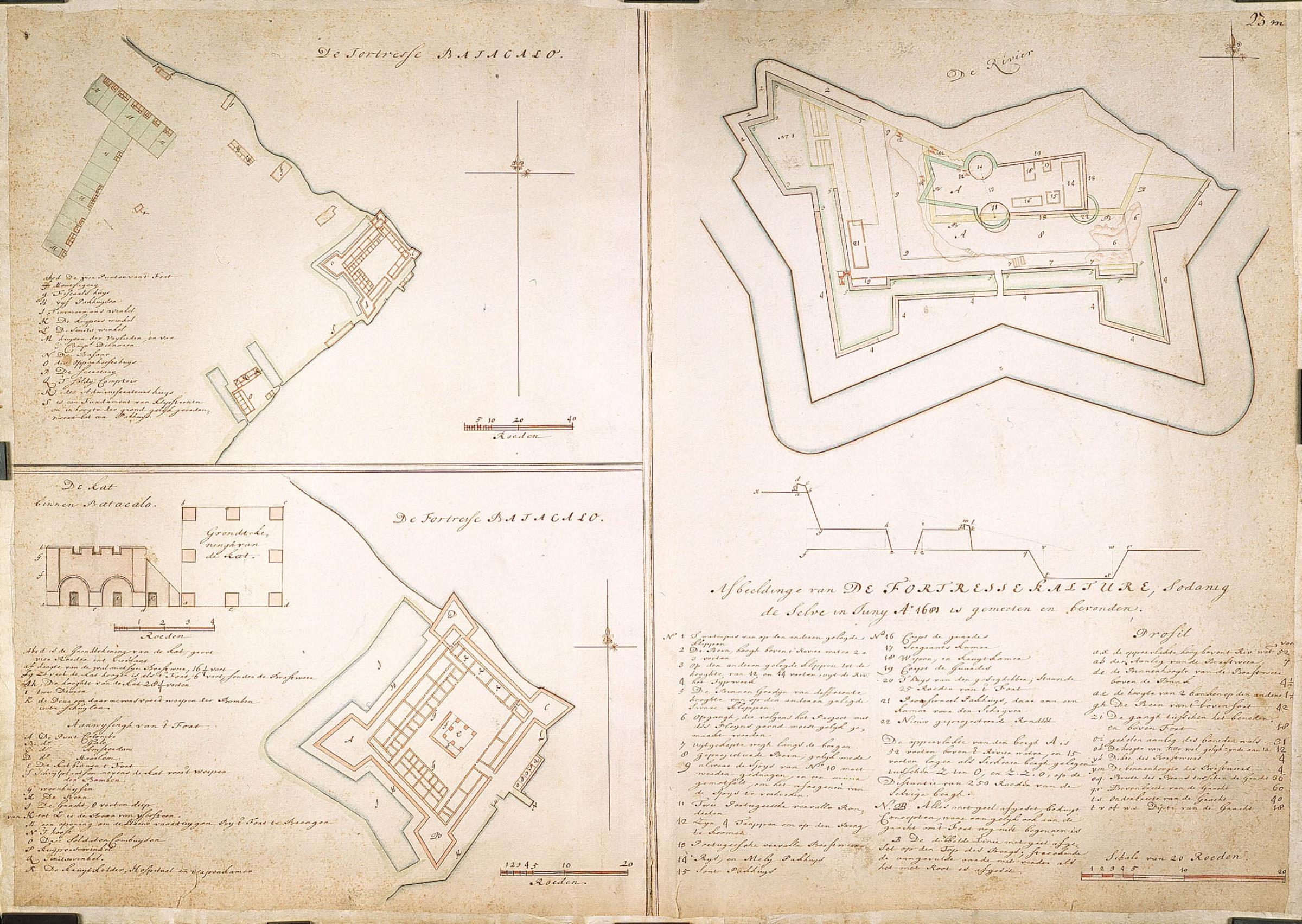
Nederlands: Titel catalogus Leupe (NA): Plan van de fortresse Batacalo.
1052a; De fortresse Batacalo; Schaal van 20 Roeden=71 strepen; 1052a [ca. 1:1062]; legenda: A-S; 1052b; De Kat binnen Batacalo; Schaal van 4 Roeden=61 strepen; 1052b [ca. 1:247]; legenda: A-R; 1052c; Afbeeldinge van de fortresse Kalture, sodanig deselve in Juny A. 1681 is gemeeten en bevonden; Schaal van 20 Roeden=115 strepen; 1052c [ca. 1:656]; legenda: 1-22; A-V. Notities verso: A.A. nr. 23 m; [verso] 576b [met potlood] n.2: 44 [Met aanwijzingen].English: According to the Leupe catalogue (NA), the original title reads: Plan van de fortresse Batacalo.
1052a; De fortresse Batacalo; Scale of 20 Rods=71 stripes; 1052a [approx. 1:1062]; key: A-S; 1052b; De Kat binnen Batacalo; Scale of 4 Rods=61 stripes; 1052b [approx. 1:247]; key: A-R; 1052c; Afbeeldinge van de fortresse Kalture, sodanig deselve in Juny A. 1681 is gemeeten en bevonden; Scale of 20 Rods=115 stripes; 1052c [ca. 1:656]; key: 1-22; A-V. Notes on reverse: A.A. nr. 23 m; [reverse] 576b [in pencil] n.2: 44 [With notes]. |
|||||||||||||||||||||||||
| Date | between 1690 and 1705 | |||||||||||||||||||||||||
| Medium |
Nederlands: ingekleurde tekening op papier
English: coloured drawing on paper |
|||||||||||||||||||||||||
| Dimensions | height: 74 cm (29.1 in); width: 53 cm (20.8 in) | |||||||||||||||||||||||||
| Collection |
|
|||||||||||||||||||||||||
| Accession number |
NL-HaNA_4.VEL_1052 (old number: VEL1052) |
|||||||||||||||||||||||||
| Inscriptions |
De fortresse Batacalo. / De Kat binnen Batacalo. / Afbeeldinge van de fortresse Kalture, sodanig deselve in Juny A. 1681 is gemeeten en bevonden.
|
|||||||||||||||||||||||||
| Notes |
English: Subjects: fortification, chart / map / plan, compass / dial, cross-section / profile, key
Nederlands: Onderwerpen: vesting, plattegrond / kaart, kompas / windroos, doorsnede / profiel, legenda
English: Post: this image is related to a VOC trading post called Kalutara |
|||||||||||||||||||||||||
| Source/Photographer |
|
|||||||||||||||||||||||||
| Permission (Reusing this file) |
|
|||||||||||||||||||||||||

| Object location | | View this and other nearby images on: OpenStreetMap |
|---|
File history
Click on a date/time to view the file as it appeared at that time.
| Date/Time | Thumbnail | Dimensions | User | Comment | |
|---|---|---|---|---|---|
| current | 16:32, 10 June 2014 | | 2,400 × 1,703 (644 KB) | HuskyBot (talk | contribs) | == {{int:filedesc}} == {{Artwork |title = {{nl|1=Plattegronden van Baticaloa en Kalture}} {{en|1=Maps of Baticaloa and Kalture}} |description = {{nl|1=Titel catalogus Leupe (NA): ''Plan van de fortresse Batacal... |
You cannot overwrite this file.
File usage on Commons
The following page uses this file:
File usage on other wikis
The following other wikis use this file:
- Usage on nl.wikipedia.org