File:AMH-4535-NA Map of Gale.jpg

Original file (2,400 × 1,731 pixels, file size: 552 KB, MIME type: image/jpeg)
Captions
Captions
Summary
editNederlands: Plattegrond van Gale
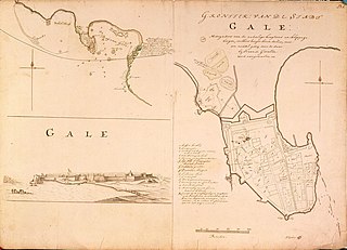
English: Map of Gale( |
||||||||||||||||||||||||||
|---|---|---|---|---|---|---|---|---|---|---|---|---|---|---|---|---|---|---|---|---|---|---|---|---|---|---|
| Author |
Nederlands: Isaac de Graaff (landmeter / kaartenmaker)
English: Isaac de Graaff (land surveyor / mapmaker) |
|||||||||||||||||||||||||
| Title |
Nederlands: Plattegrond van Gale
English: Map of Gale |
|||||||||||||||||||||||||
| Description |
Nederlands: Titel catalogus Leupe (NA): Grondteekening van de stadt Gale, mitsgaders van de nadeelige hoogtens en klippige bergen enz..
De afbeelding bestaat uit drie delen: de plattegrond van de stad, een aanzicht op de stad en een plattegrond van de baai van Gale. Gerestaureerd; notities verso zijn verloren gegaan door de restauratie. Rechts boven: 23.k.English: According to the Leupe catalogue (NA), the original title reads: Grondteekening van de stadt Gale, mitsgaders van de nadeelige hoogtens en klippige bergen enz..
The illustration is made up of three parts: a map of the city, a view of the city and a map of Gale bay. Restored; notes on reverse have been excised as a result of restoration. Top right: 23.k. |
|||||||||||||||||||||||||
| Date | between 1690 and 1743 | |||||||||||||||||||||||||
| Medium |
Nederlands: ingekleurde tekening op papier
English: coloured drawing on paper |
|||||||||||||||||||||||||
| Dimensions | height: 74 cm (29.1 in); width: 53 cm (20.8 in) | |||||||||||||||||||||||||
| Collection |
|
|||||||||||||||||||||||||
| Accession number |
NL-HaNA_4.VEL_1054 (old number: VEL1054) |
|||||||||||||||||||||||||
| Inscriptions |
Grondtek: van de stadt Gale
|
|||||||||||||||||||||||||
| Notes |
English: Subjects: fortification, key, fortification, powder magazine / powder mill, chart / map / plan, church / parsonage, cemetery / graveyard, survey / view
Nederlands: Onderwerpen: vesting, legenda, vesting, kruithuis / kruitmolen, plattegrond / kaart, kerk / pastorie, begraafplaats / kerkhof, overzicht / aanzicht
English: Post: this image is related to a VOC trading post called Galle |
|||||||||||||||||||||||||
| Source/Photographer |
|
|||||||||||||||||||||||||
| Permission (Reusing this file) |
|
|||||||||||||||||||||||||

| Object location | | View this and other nearby images on: OpenStreetMap |
|---|
File history
Click on a date/time to view the file as it appeared at that time.
| Date/Time | Thumbnail | Dimensions | User | Comment | |
|---|---|---|---|---|---|
| current | 16:32, 10 June 2014 | | 2,400 × 1,731 (552 KB) | HuskyBot (talk | contribs) | == {{int:filedesc}} == {{Artwork |title = {{nl|1=Plattegrond van Gale}} {{en|1=Map of Gale}} |description = {{nl|1=Titel catalogus Leupe (NA): ''Grondteekening van de stadt Gale, mitsgaders van de nadeelige hoo... |
You cannot overwrite this file.
File usage on Commons
The following page uses this file:
File usage on other wikis
The following other wikis use this file:
- Usage on nl.wikipedia.org