File:AMH-4544-NA Map of the fort at Gale.jpg

Size of this preview: 369 × 599 pixels. Other resolutions: 148 × 240 pixels | 295 × 480 pixels | 473 × 768 pixels | 630 × 1,024 pixels | 1,478 × 2,400 pixels.
Original file (1,478 × 2,400 pixels, file size: 411 KB, MIME type: image/jpeg)
Captions
Captions
Add a one-line explanation of what this file represents
Summary
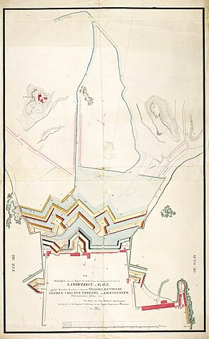
edit| Nederlands: Plattegrond van het fort van Gale
English: Map of the fort at Gale ( |
||||||||||||||||||||||||
|---|---|---|---|---|---|---|---|---|---|---|---|---|---|---|---|---|---|---|---|---|---|---|---|---|
| Author |
Nederlands: P. Elias (landmeter / kaartenmaker), Carl Friedrich Reimer (gewerkt naar)
English: P. Elias (land surveyor / mapmaker), Carl Friedrich Reimer (copied after) |
|||||||||||||||||||||||
| Title |
Nederlands: Plattegrond van het fort van Gale
English: Map of the fort at Gale |
|||||||||||||||||||||||
| Description |
Nederlands: Titel catalogus Leupe (NA): Hoofdplan van een project tot verbetering der vestingwerken van de Landfront te Gale, gelyk hetzelve beraamt is door de H. H. Vaillant, Ver-Huell en Graevesteyn, Commissarissen-Militair enz..
Notities verso: No. 8 Gale / 583 [met vette cijfers gestempeld op een etiketje].
English: According to the Leupe catalogue (NA), the original title reads: Hoofdplan van een project tot verbetering der vestingwerken van de Landfront te Gale, gelyk hetzelve beraamt is door de H. H. Vaillant, Ver-Huell en Graevesteyn, Commissarissen-Militair enz..
Notes on reverse: No. 8 Gale / 583 [printed in bold on a small label]. |
|||||||||||||||||||||||
| Date | circa 1750 | |||||||||||||||||||||||
| Medium |
Nederlands: ingekleurde tekening op papier
English: coloured drawing on paper |
|||||||||||||||||||||||
| Dimensions | height: 65 cm (25.5 in); width: 105.5 cm (41.5 in) | |||||||||||||||||||||||
| Collection |
|
|||||||||||||||||||||||
| Accession number |
NL-HaNA_4.VEL_1065 (old number: VEL1065) |
|||||||||||||||||||||||
| Inscriptions |
Hoofdplan van een Project tot Verbeetering der Vestingwerken van de Landfront te Gale, gelyk hetzelve beraamt is door de Weledelgestrege Heeren Vaillant, Ver-Huell en Graevesteyn, Commissarissen-Militair author: Gecopieerd naar de origineel tekening van de Majoor-ingenieur Reimer, door P. Elias |
|||||||||||||||||||||||
| Notes |
English: Subjects: chart / map / plan, fortification
Nederlands: Onderwerpen: plattegrond / kaart, vesting
English: Post: this image is related to a VOC trading post called Galle |
|||||||||||||||||||||||
| Source/Photographer |
|
|||||||||||||||||||||||
| Permission (Reusing this file) |
|
|||||||||||||||||||||||

| Object location | | View this and other nearby images on: OpenStreetMap |
|---|
File history
Click on a date/time to view the file as it appeared at that time.
| Date/Time | Thumbnail | Dimensions | User | Comment | |
|---|---|---|---|---|---|
| current | 16:34, 10 June 2014 | | 1,478 × 2,400 (411 KB) | HuskyBot (talk | contribs) | == {{int:filedesc}} == {{Artwork |title = {{nl|1=Plattegrond van het fort van Gale}} {{en|1=Map of the fort at Gale}} |description = {{nl|1=Titel catalogus Leupe (NA): ''Hoofdplan van een project tot verbeterin... |
You cannot overwrite this file.
File usage on Commons
The following page uses this file: