File:AMH-4594-NA Map of Batavia.jpg
Original file (2,400 × 1,709 pixels, file size: 605 KB, MIME type: image/jpeg)
Captions
Captions
Summary edit
| Nederlands: Plattegrond van Batavia
English: Map of Batavia Bahasa Indonesia: Peta Batavia ( |
||||||||||||||||||||||||
|---|---|---|---|---|---|---|---|---|---|---|---|---|---|---|---|---|---|---|---|---|---|---|---|---|
| Author |
Nederlands: Anoniem / Anonymous
English: Anoniem / Anonymous |
|||||||||||||||||||||||
| Title |
Nederlands: Plattegrond van Batavia
English: Map of Batavia
Bahasa Indonesia: Peta Batavia |
|||||||||||||||||||||||
| Description |
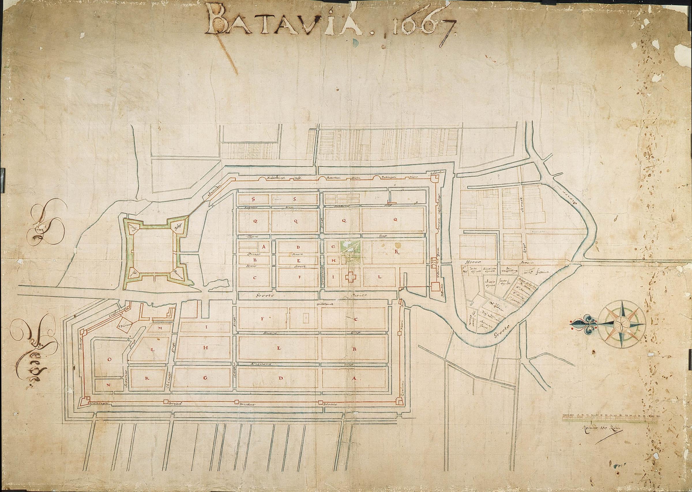
Nederlands: Titel catalogus Leupe (NA): Plan van het Casteel en de stad Batavia.
Gerestaureerd maar de letters van het opschrift en jaar zijn door inktvraat helemaal verdwenen. Notities verso: [verloren gegaan door de restauratie].English: According to the Leupe catalogue (NA), the original title reads: Plan van het Casteel en de stad Batavia.
Restored, but the caption and year have been completely eaten away. Notes on reverse: [lost through restoration].Bahasa Indonesia: Menurut katalog Leupe (NA), judul aslinya berbunyi: Plan van het Casteel en de stad Batavia.
Dipulihkan, tetapi keterangan dan tahun telah benar-benar hilang. Tulisan di belakang: [hilang saat restorasi]. |
|||||||||||||||||||||||
| Date | 1667 | |||||||||||||||||||||||
| Medium |
Nederlands: ingekleurde tekening op papier
English: coloured drawing on paper
Bahasa Indonesia: gambar berwarna di atas kertas |
|||||||||||||||||||||||
| Dimensions | height: 116 cm (45.6 in); width: 83.5 cm (32.8 in) | |||||||||||||||||||||||
| Collection |
|
|||||||||||||||||||||||
| Accession number |
NL-HaNA_4.VEL_1182 (old number: VEL1182) |
|||||||||||||||||||||||
| Inscriptions |
Batavia 1667
|
|||||||||||||||||||||||
| Notes |
English: Subjects: fortification, compass / dial, anchorage / pier / harbour, chart / map / plan
Nederlands: Onderwerpen: vesting, kompas / windroos, rede / haven / pier, plattegrond / kaart
English: Post: this image is related to a VOC trading post called Jakarta |
|||||||||||||||||||||||
| Source/Photographer |
|
|||||||||||||||||||||||
| Permission (Reusing this file) |
|
|||||||||||||||||||||||

| Object location | | View this and other nearby images on: OpenStreetMap |
|---|
File history
Click on a date/time to view the file as it appeared at that time.
| Date/Time | Thumbnail | Dimensions | User | Comment | |
|---|---|---|---|---|---|
| current | 16:43, 10 June 2014 | | 2,400 × 1,709 (605 KB) | HuskyBot (talk | contribs) | == {{int:filedesc}} == {{Artwork |title = {{nl|1=Plattegrond van Batavia}} {{en|1=Map of Batavia}} |description = {{nl|1=Titel catalogus Leupe (NA): ''Plan van het Casteel en de stad Batavia''. Gerestaureerd m... |
You cannot overwrite this file.
File usage on Commons
The following page uses this file: