File:AMH-4600-NA Map of the fort at Kelang.jpg

Size of this preview: 476 × 600 pixels. Other resolutions: 190 × 240 pixels | 381 × 480 pixels | 609 × 768 pixels | 812 × 1,024 pixels | 1,904 × 2,400 pixels.
Original file (1,904 × 2,400 pixels, file size: 634 KB, MIME type: image/jpeg)
Captions
Captions
Add a one-line explanation of what this file represents
Summary edit
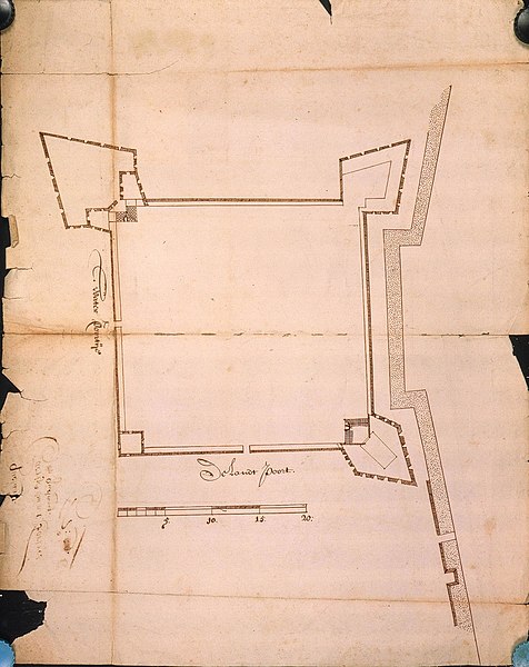
Nederlands: Plattegrond van het fort te Kelang
English: Map of the fort at Kelang( |
||||||||||||||||||||||||
|---|---|---|---|---|---|---|---|---|---|---|---|---|---|---|---|---|---|---|---|---|---|---|---|---|
| Author |
Nederlands: Anoniem / Anonymous
English: Anoniem / Anonymous |
|||||||||||||||||||||||
| Title |
Nederlands: Plattegrond van het fort te Kelang
English: Map of the fort at Kelang |
|||||||||||||||||||||||
| Description |
Nederlands: Titel catalogus Leupe (NA): Caartje van de Fortres op Quelang.
De randen zijn gerafeld en gescheurd. Notities verso: quelang Caertje van t' fortres op quelang No. 6 / 09 [dit moet het folionummer zijn, er heeft nog een cijfer voorgestaan maar door een gat in het papier is dat verloren gegaan] / Behoort by de papieren over China 1667 Portefeuille 1667 III / 598 f.English: According to the Leupe catalogue (NA), the original title reads: Caartje van de Fortres op Quelang.
The edges are frayed and torn. Notes on reverse: quelang Caertje van t' fortres op quelang No. 6 / 09 [most likely the folio number; it was preceded by another digit, but this has been excised due to a hole in the paper] / Behoort by de papieren over China 1667 Portefeuille 1667 III / 598 f. |
|||||||||||||||||||||||
| Date | circa 1667 | |||||||||||||||||||||||
| Medium |
Nederlands: ingekleurde tekening op papier
English: coloured drawing on paper |
|||||||||||||||||||||||
| Collection |
|
|||||||||||||||||||||||
| Accession number |
NL-HaNA_4.VEL_1128 (old number: VEL1128) |
|||||||||||||||||||||||
| Inscriptions |
-
|
|||||||||||||||||||||||
| Notes |
English: Subjects: gate, fortification, chart / map / plan
Nederlands: Onderwerpen: poort, vesting, plattegrond / kaart
English: Post: this image is related to a VOC trading post called Chi-lung |
|||||||||||||||||||||||
| Source/Photographer |
|
|||||||||||||||||||||||
| Permission (Reusing this file) |
|
|||||||||||||||||||||||

| Object location | | View this and other nearby images on: OpenStreetMap |
|---|
File history
Click on a date/time to view the file as it appeared at that time.
| Date/Time | Thumbnail | Dimensions | User | Comment | |
|---|---|---|---|---|---|
| current | 16:44, 10 June 2014 | | 1,904 × 2,400 (634 KB) | HuskyBot (talk | contribs) | == {{int:filedesc}} == {{Artwork |title = {{nl|1=Plattegrond van het fort te Kelang}} {{en|1=Map of the fort at Kelang}} |description = {{nl|1=Titel catalogus Leupe (NA): ''Caartje van de Fortres op Quelang''.... |
You cannot overwrite this file.
File usage on Commons
The following page uses this file: