File:AMH-5641-KB Map of Batavia and environs.jpg

Original file (2,400 × 1,941 pixels, file size: 672 KB, MIME type: image/jpeg)
Captions
Captions
Summary edit
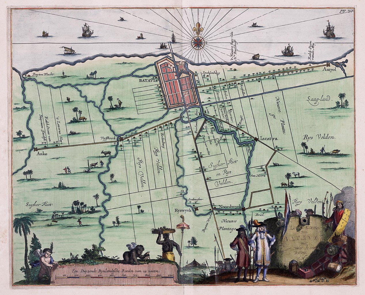
Nederlands: Kaart van Batavia en omgeving
                     English:  Map of Batavia and environs
                     Bahasa Indonesia:  Peta Batavia dan sekitarnya
( |
|||||||||||||||||||||
|---|---|---|---|---|---|---|---|---|---|---|---|---|---|---|---|---|---|---|---|---|---|
| Author |
Nederlands: Weduwe van Jacob van Meurs (uitgever)
English: Weduwe van Jacob van Meurs (publisher) |
||||||||||||||||||||
| Title |
Nederlands: Kaart van Batavia en omgeving
English: Map of Batavia and environs
Bahasa Indonesia: Peta Batavia dan sekitarnya |
||||||||||||||||||||
| Description |
Nederlands: Kaart van Batavia en omgeving uit de Atlas van der Hagen, Koninklijke Bibliotheek, Den Haag Deel 4.
Zwart-wit uitvoering van dezelfde kaart: Koninklijke Bibliotheek, inv. nr. 388 A 9 deel II, na p. 196. Cf. Westfries Museum, inv. nr. 15252, Tropenmuseum / KIT, inv. nr. 5681-3 en Koninklijke Bibliotheek, inv. nr. 2102A 7, p. 118.English: Map of Batavia and environs taken from the Atlas van der Hagen, Koninklijk Bibliotheek, The Hague, Part 4.
Black & whiteversion of the same map: Koninklijke Bibliotheek, inv. nr. 388 A 9 deel II, na p. 196. Cf. Westfries Museum, inv. nr. 15252, Tropenmuseum / KIT, inv. nr. 5681-3 and Koninklijke Bibliotheek, inv. nr. 2102A 7, p. 118.Bahasa Indonesia: Peta Batavia dan sekitarnya diambil dari Atlas van der Hagen, Koninklijk Bibliotheek, Den Haag, Bagian 4.
Versi hitam putih pada peta yang sama: Koninklijke Bibliotheek, inv. nr. 388 A 9 deel II, na p. 196. Cf. Westfries Museum, inv. nr. 15252, Tropenmuseum / KIT, inv. nr. 5681-3 and Koninklijke Bibliotheek, inv. nr. 2102A 7, p. 118. |
||||||||||||||||||||
| Date | 1682 | ||||||||||||||||||||
| Medium |
Nederlands: koperdruk op papier
English: copperplate printing on paper
Bahasa Indonesia: pencetakan pelat tembaga di atas kertas |
||||||||||||||||||||
| Dimensions | height: 36 cm (14.1 in); width: 28 cm (11 in) | ||||||||||||||||||||
| Collection |
|
||||||||||||||||||||
| Accession number |
1049B13_020 |
||||||||||||||||||||
| Inscriptions |
Landt Caerte van BATAVIA met Haer onder hoorende Forten
author: J.N. |
||||||||||||||||||||
| Notes |
English: Subjects: chart / map / plan, ship / vessel, fortification, banderole / cartouche / ornamentation, European, compass / dial, Asians & Africans
Nederlands: Onderwerpen: plattegrond / kaart, schip / vaartuig, vesting, banderol / cartouche / versiering, Europeanen, kompas / windroos, Aziaten & Afrikanen
English: Post: this image is related to a VOC trading post called Jakarta |
||||||||||||||||||||
| Source/Photographer |
|
||||||||||||||||||||
| Permission (Reusing this file) |
|
||||||||||||||||||||
| Other versions |
|
||||||||||||||||||||


| Object location | | View this and other nearby images on: OpenStreetMap |
|---|
File history
Click on a date/time to view the file as it appeared at that time.
| Date/Time | Thumbnail | Dimensions | User | Comment | |
|---|---|---|---|---|---|
| current | 20:52, 23 May 2014 | | 2,400 × 1,941 (672 KB) | HuskyBot (talk | contribs) | == {{int:filedesc}} == {{Artwork |title = {{nl|Kaart van Batavia en omgeving}} {{en|Map of Batavia and environs}} |description = {{nl|Kaart van Batavia en omgeving uit de Atlas van der Hagen, Koninklijke Biblio... |
You cannot overwrite this file.
File usage on Commons
The following 7 pages use this file:
- Koninklijke Bibliotheek/Maps and atlases
- Maps and atlases from Koninklijke Bibliotheek
- Commons:Atlas of Mutual Heritage
- Commons:Batch uploading/Atlas of Mutual Heritage
- File:AMH-5641-KB Map of Batavia and environs.jpg
- File:A town plan of the trading port Batavia Wellcome L0038151.jpg
- File:Histoire des deux Indes-Atlas-d31-C13-Batavia et environs.png
File usage on other wikis
The following other wikis use this file:
- Usage on nl.wikipedia.org