File:AMH-6681-KB Map of South America.jpg
Size of this preview: 800 × 581 pixels. Other resolutions: 320 × 233 pixels | 640 × 465 pixels | 1,024 × 744 pixels | 1,280 × 930 pixels | 2,400 × 1,744 pixels.
Original file (2,400 × 1,744 pixels, file size: 1,006 KB, MIME type: image/jpeg)
Captions
Captions
Add a one-line explanation of what this file represents
Summary edit
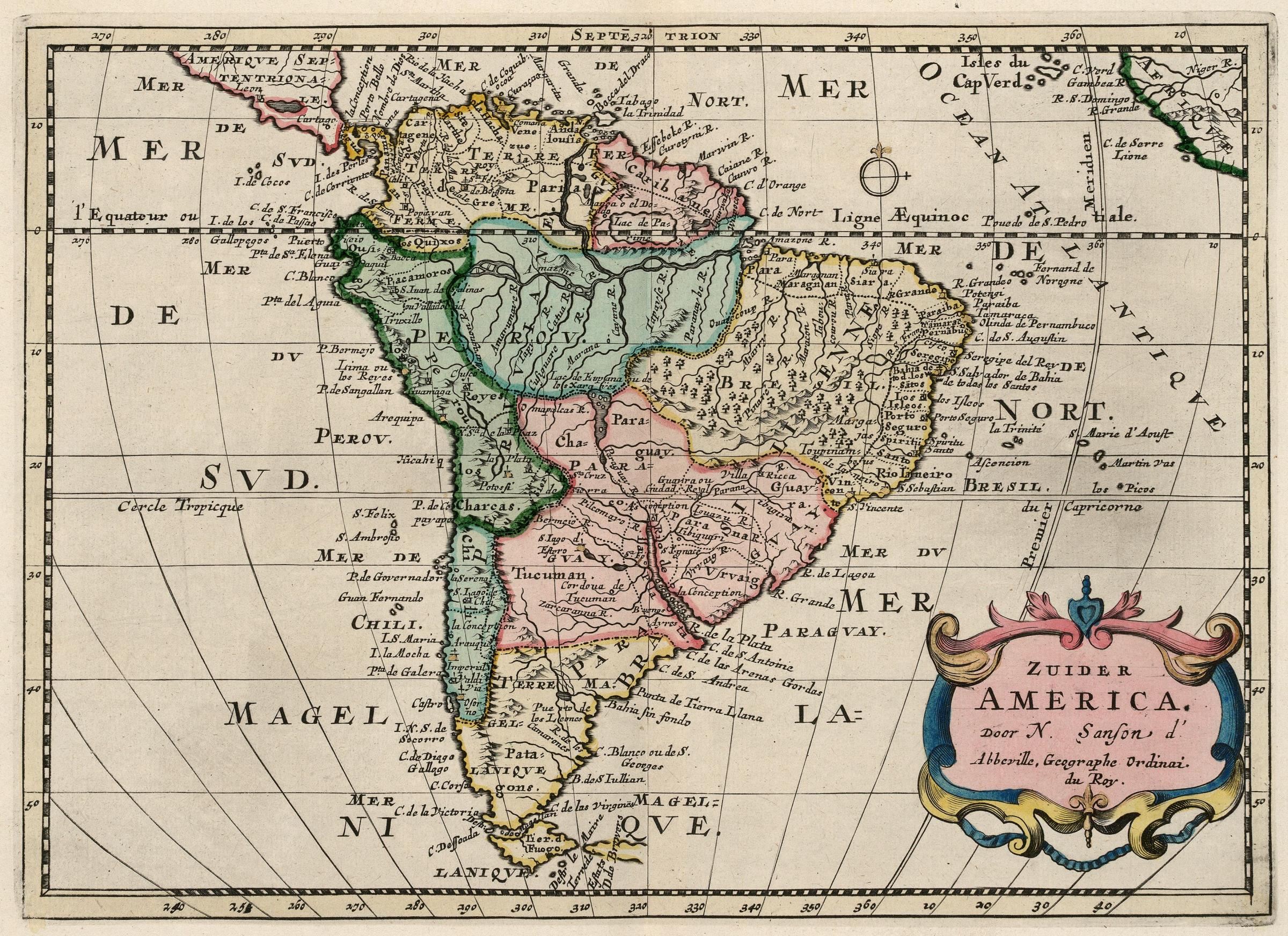
Nederlands: Kaart van Zuid-Amerika
English: Map of South America( |
|||||||||||||||||||||||||||||||||||||||||||||||||||||||||||||||||||||||||||
|---|---|---|---|---|---|---|---|---|---|---|---|---|---|---|---|---|---|---|---|---|---|---|---|---|---|---|---|---|---|---|---|---|---|---|---|---|---|---|---|---|---|---|---|---|---|---|---|---|---|---|---|---|---|---|---|---|---|---|---|---|---|---|---|---|---|---|---|---|---|---|---|---|---|---|---|
| Author |
Nederlands: A. d' Winter (graveur / etser), Nicolas Sanson d'Abbeville (landmeter / kaartenmaker), François Halma (uitgever)
English: A. d' Winter (engraver / etcher), Nicolas Sanson d'Abbeville (land surveyor / mapmaker), François Halma (publisher) |
||||||||||||||||||||||||||||||||||||||||||||||||||||||||||||||||||||||||||
| Title |
Nederlands: Kaart van Zuid-Amerika
English: Map of South America |
||||||||||||||||||||||||||||||||||||||||||||||||||||||||||||||||||||||||||
| Description |
Nederlands: Kaart van Zuid-Amerika.
Zuider America.
English: Map of South America.
Zuider America. |
||||||||||||||||||||||||||||||||||||||||||||||||||||||||||||||||||||||||||
| Date | circa 1705 | ||||||||||||||||||||||||||||||||||||||||||||||||||||||||||||||||||||||||||
| Medium |
Nederlands: ingekleurde gravure op papier
English: coloured engraving on paper |
||||||||||||||||||||||||||||||||||||||||||||||||||||||||||||||||||||||||||
| Dimensions | height: 20.5 cm (8 in); width: 28.5 cm (11.2 in) | ||||||||||||||||||||||||||||||||||||||||||||||||||||||||||||||||||||||||||
| Collection |
|
||||||||||||||||||||||||||||||||||||||||||||||||||||||||||||||||||||||||||
| Accession number |
368 E 1 deel III, na p. 382 |
||||||||||||||||||||||||||||||||||||||||||||||||||||||||||||||||||||||||||
| Inscriptions |
Zuider America
author: Door N. Sanson d' Abbeville, Geographe Ordinai. du Roy. |
||||||||||||||||||||||||||||||||||||||||||||||||||||||||||||||||||||||||||
| Notes |
English: Subjects: chart / map / plan, compass / dial, banderole / cartouche / ornamentation
Nederlands: Onderwerpen: plattegrond / kaart, kompas / windroos, banderol / cartouche / versiering
English: Post: this image is related to a WIC trading post called Castro |
||||||||||||||||||||||||||||||||||||||||||||||||||||||||||||||||||||||||||
| Source/Photographer |
|
||||||||||||||||||||||||||||||||||||||||||||||||||||||||||||||||||||||||||
| Permission (Reusing this file) |
|
||||||||||||||||||||||||||||||||||||||||||||||||||||||||||||||||||||||||||


| Object location | | View this and other nearby images on: OpenStreetMap |
|---|
File history
Click on a date/time to view the file as it appeared at that time.
| Date/Time | Thumbnail | Dimensions | User | Comment | |
|---|---|---|---|---|---|
| current | 11:19, 10 June 2014 | | 2,400 × 1,744 (1,006 KB) | HuskyBot (talk | contribs) | == {{int:filedesc}} == {{Artwork |title = {{nl|1=Kaart van Zuid-Amerika}} {{en|1=Map of South America}} |description = {{nl|1=Kaart van Zuid-Amerika. ''Zuider America''.}} {{en|1=Map of S... |
You cannot overwrite this file.
File usage on Commons
The following page uses this file: