File:AMH-7752-KB Map of the northwest coast of South America and the southern part of Central America.jpg

Original file (2,400 × 1,882 pixels, file size: 1.07 MB, MIME type: image/jpeg)
Captions
Captions
Summary edit
Nederlands: Kaart van de Noordwest-kust van Zuid-Amerika en het zuidelijk deel van Midden-Amerika
English: Map of the northwest coast of South America and the southern part of Central America( |
||||||||||||||||||||||||
|---|---|---|---|---|---|---|---|---|---|---|---|---|---|---|---|---|---|---|---|---|---|---|---|---|
| Author |
creator QS:P170,Q520327
Nederlands: Anoniem / Anonymous (landmeter / kaartenmaker), Wilhelm (Jansz.) Blaeu (uitgever)
English: Anoniem / Anonymous (land surveyor / mapmaker), Wilhelm (Jansz.) Blaeu (publisher) |
|||||||||||||||||||||||
| Title |
Nederlands: Kaart van de Noordwest-kust van Zuid-Amerika en het zuidelijk deel van Midden-Amerika
English: Map of the northwest coast of South America and the southern part of Central America |
|||||||||||||||||||||||
| Description |
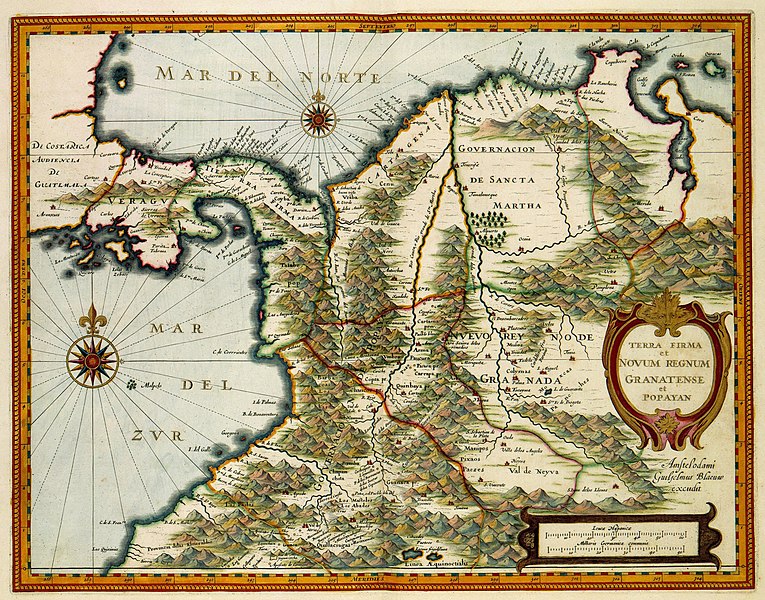
Nederlands: Kaart van de Noordwest-kust van Zuid-Amerika en het zuidelijk deel van Midden-Amerika.
Terra Firma et Novum Regnum Granatense et Popayan. Behalve in Azië waren de Nederlanders ook actief in Noord-, Midden en Zuid-Amerika. De handelsactiviteiten werden daar gecoördineerd door de in 1621 opgerichte West-Indische Compagnie. Dat de compagnie er vrij spoedig in slaagde om deze uitgestrekte gebieden te bestrijken, was vooral te danken aan het goede kaartmateriaal waarover men beschikte. Veel van dat materiaal werd beheerd door Willem Jansz.Blaeu (1571-1638) die behalve uitgever, ook de officiële kaartenmaker van de Oost-Indische Compagnie was. Vanzelfsprekend mocht Blaeu dit uiterst delicate kaartmateriaal niet door middel van zijn atlassen aan het grote publiek prijsgeven en moest hij voor het samenstellen van zijn kaarten gebruik maken van andere materialen. Voor deze kaart van Columbia en de landengte Panama, greep Blaeu terug op de 'Beschrijvinghe van West-Indien', een fameus boek van Johannes de Laet (1583-1649) uit 1625. De kaart kwam ook terug in de 'Atlas Maior' uit 1665. Blaeu wijzigde de kaart enigszins. Cf. Koninklijke Bibliotheek, Den Haag, inv. nr. 36 G 19 na p. 300; en Idem, inv. nr. 40 E 6 na p. 266.English: Map of the northwest coast of South America and the southern part of Central America.
Terra Firma et Novum Regnum Granatense et Popayan. In addition to Asia, the Dutch also maintained an active presence in North, Central and South America. The trading activities there were coordinated by the West India Company or West-Indische Compagnie, which was founded in 1621. That the company was able to cover these extensive areas within a fairly short period was due in no small measure to the superior quality of the maps they had at their disposal. Much of this material was managed by Willem Jansz. Blaeu (1571-1638) who was not only a publisher but also the official mapmaker of the Dutch East India Company. Naturally Blaeu was not permitted to reveal this extremely sensitive geographical data to the public at large, and so he was forced to make use of other materials in order to compile his maps. For this map of Columbia and the Panama peninsula, Blaeu made use of the 'Beschrijvinghe van West-Indien', a famous book by Johannes de Laet (1583-1649) dating from 1625. The map is also featured in the 'Atlas Maior' of 1665. Blaeu amended the map to some extent. -Cf. Koninklijke Bibliotheek, The Hague, inv. nr. 36 G 19 after p.300; and Ibid. inv. nr. 40 E 6 after p. 266. |
|||||||||||||||||||||||
| Date |
1630 date QS:P571,+1630-00-00T00:00:00Z/9 |
|||||||||||||||||||||||
| Medium |
Nederlands: ingekleurde gravure op papier
English: coloured engraving on paper |
|||||||||||||||||||||||
| Dimensions |
height: 48 cm (18.8 in); width: 37 cm (14.5 in) dimensions QS:P2048,48U174728 dimensions QS:P2049,37U174728 |
|||||||||||||||||||||||
| Collection |
institution QS:P195,Q1526131 |
|||||||||||||||||||||||
| Accession number |
1049B13_087 |
|||||||||||||||||||||||
| Inscriptions |
Terra Firma et Novum Regnum Granatense et Popayan
author: Amstelodami Guiljelmus Blaeuw excudit |
|||||||||||||||||||||||
| Notes |
English: Subjects: chart / map / plan, banderole / cartouche / ornamentation, compass / dial
Nederlands: Onderwerpen: plattegrond / kaart, banderol / cartouche / versiering, kompas / windroos
English: Post: this image is related to a WIC trading post called Aruba |
|||||||||||||||||||||||
| Source/Photographer |
|
|||||||||||||||||||||||
| Permission (Reusing this file) |
|
|||||||||||||||||||||||
| Object location | 12° 31′ 20.61″ N, 69° 58′ 54.36″ W | View this and other nearby images on: OpenStreetMap |
|---|
File history
Click on a date/time to view the file as it appeared at that time.
| Date/Time | Thumbnail | Dimensions | User | Comment | |
|---|---|---|---|---|---|
| current | 14:33, 10 June 2014 |  | 2,400 × 1,882 (1.07 MB) | HuskyBot (talk | contribs) | == {{int:filedesc}} == {{Artwork |title = {{nl|1=Kaart van de Noordwest-kust van Zuid-Amerika en het zuidelijk deel van Midden-Amerika}} {{en|1=Map of the northwest coast of South America and the southern part of Cent... |
You cannot overwrite this file.
File usage on Commons
The following page uses this file:


