File:AVENUE OF THE GIANTS, OLD HIGHWAY 101, ROAD VIEW .5 MILE NORTH OF MIRANDA. HUMBOLDT COUNTY, CALIFORNIA. LOOKING NW. - Redwood National and State Parks Roads, California coast from HAER CA-269-20.tif

Size of this JPG preview of this TIF file: 482 × 599 pixels. Other resolutions: 193 × 240 pixels | 386 × 480 pixels | 617 × 768 pixels | 823 × 1,024 pixels | 1,647 × 2,048 pixels | 4,334 × 5,390 pixels.
Original file (4,334 × 5,390 pixels, file size: 22.28 MB, MIME type: image/tiff)
Captions
Captions
Add a one-line explanation of what this file represents
Summary edit
| AVENUE OF THE GIANTS, OLD HIGHWAY 101, ROAD VIEW .5 MILE NORTH OF MIRANDA. HUMBOLDT COUNTY, CALIFORNIA. LOOKING NW. - Redwood National and State Parks Roads, California coast from Crescent City to Trinidad, Crescent City, Del Norte County, CA | ||||
|---|---|---|---|---|
| Photographer |
Grogan, Brian Related names:
|
|||
| Title |
AVENUE OF THE GIANTS, OLD HIGHWAY 101, ROAD VIEW .5 MILE NORTH OF MIRANDA. HUMBOLDT COUNTY, CALIFORNIA. LOOKING NW. - Redwood National and State Parks Roads, California coast from Crescent City to Trinidad, Crescent City, Del Norte County, CA |
|||
| Depicted place | California; Del Norte County; Crescent City | |||
| Date | 2000 | |||
| Dimensions | 4 x 5 in. | |||
| Current location |
Library of Congress Prints and Photographs Division Washington, D.C. 20540 USA http://hdl.loc.gov/loc.pnp/pp.print |
|||
| Accession number |
HAER CA-269-20 |
|||
| Credit line |
|
|||
| Notes |
|
|||
| References |
|
|||
| Source | https://www.loc.gov/pictures/item/ca2890.photos.193727p | |||
| Permission (Reusing this file) |
|
|||

| Object location | | View this and other nearby images on: OpenStreetMap |
|---|
File history
Click on a date/time to view the file as it appeared at that time.
| Date/Time | Thumbnail | Dimensions | User | Comment | |
|---|---|---|---|---|---|
| current | 23:25, 7 July 2014 | 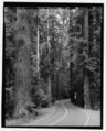 | 4,334 × 5,390 (22.28 MB) | Fæ (talk | contribs) | GWToolset: Creating mediafile for Fæ. HABS 05 July 2014 (401:500) |
You cannot overwrite this file.
File usage on Commons
The following page uses this file: