File:A 'barrel shot' looking down the track and through the 114'- 8-1-2' south thru truss approach span, showing pole line supported across top of steal superstructure. The 364' - HAER ALA,36-BRIPO.V,1-18.tif

Size of this JPG preview of this TIF file: 476 × 600 pixels. Other resolutions: 190 × 240 pixels | 381 × 480 pixels | 609 × 768 pixels | 812 × 1,024 pixels | 1,625 × 2,048 pixels | 3,935 × 4,960 pixels.
Original file (3,935 × 4,960 pixels, file size: 18.62 MB, MIME type: image/tiff)
Captions
Captions
Add a one-line explanation of what this file represents
Summary edit
| Photographer |
Beasley, C. N. Related names:
|
|||
| Title |
A 'barrel shot' looking down the track and through the 114'- 8-1-2' south thru truss approach span, showing pole line supported across top of steal superstructure. The 364' - 0-1-4' swing span over river has been used by various Railroads for a period of 90 years. - Bridgeport Swing Span Bridge, Spanning Tennessee River, Bridgeport, Jackson County, AL |
|||
| Depicted place | Alabama; Jackson County; Bridgeport | |||
| Date | 1980 | |||
| Medium | 4 x 5 in. | |||
| Current location |
Library of Congress Prints and Photographs Division Washington, D.C. 20540 USA http://hdl.loc.gov/loc.pnp/pp.print |
|||
| Accession number |
HAER ALA,36-BRIPO.V,1-18 |
|||
| Credit line |
|
|||
| Notes |
|
|||
| Source | https://www.loc.gov/pictures/item/al0340.photos.002816p | |||
| Permission (Reusing this file) |
|

| Object location | | View this and other nearby images on: OpenStreetMap |
|---|
File history
Click on a date/time to view the file as it appeared at that time.
| Date/Time | Thumbnail | Dimensions | User | Comment | |
|---|---|---|---|---|---|
| current | 00:24, 29 June 2014 | 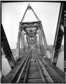 | 3,935 × 4,960 (18.62 MB) | Fæ (talk | contribs) | GWToolset: Creating mediafile for Fæ. HABS batch upload restart 26 June 2014 (p21:101)x |
You cannot overwrite this file.
File usage on Commons
The following page uses this file: