File:A List of the Severall Barracks that are in Each Province in the Kingdom of Ireland with the Number of Troops and Companys each barrack will contain - (By H. Moll Geographer) - btv1b530564830.jpg
Original file (3,544 × 2,912 pixels, file size: 1.52 MB, MIME type: image/jpeg)
Captions
Captions
Summary edit
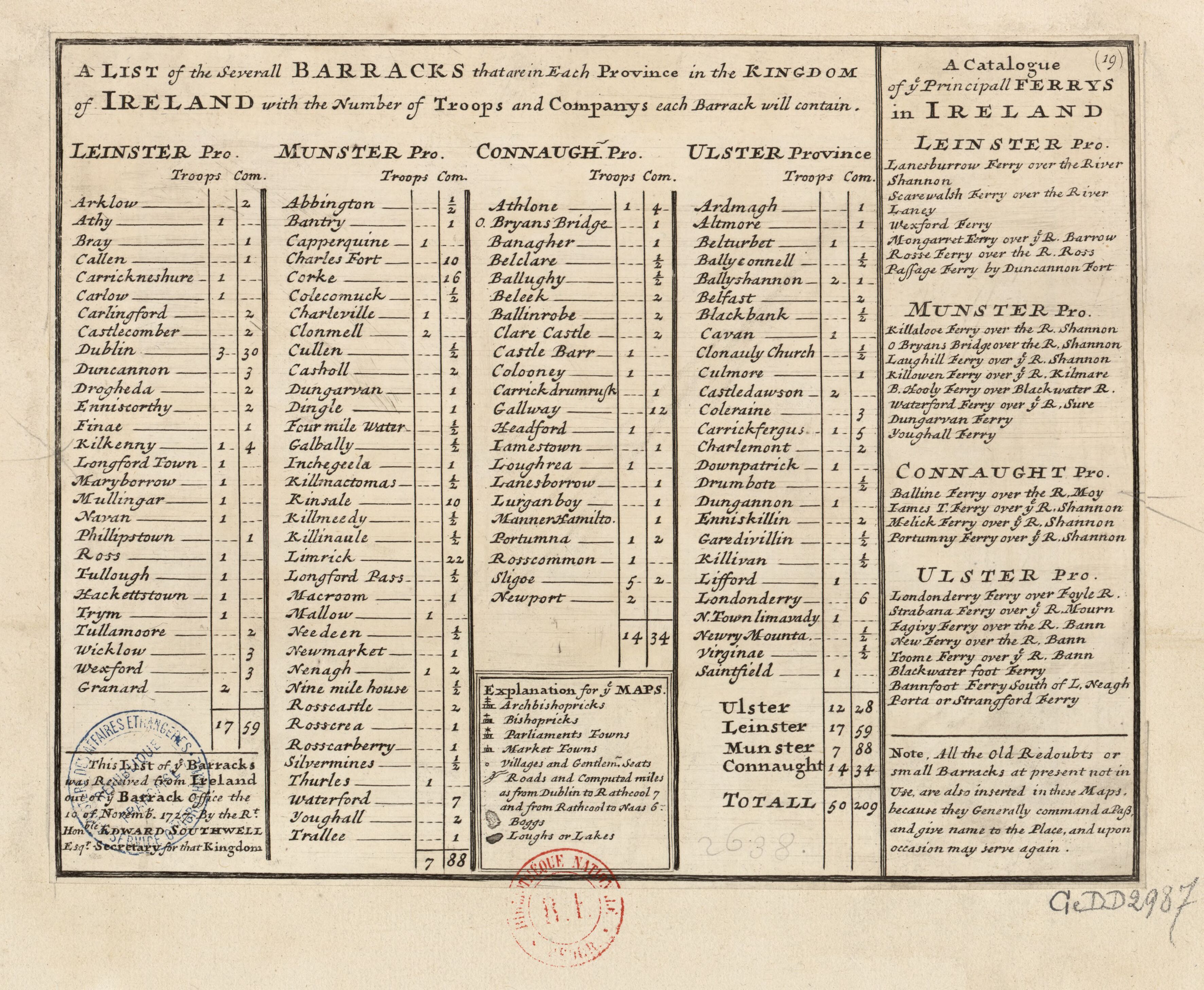
| 19. A new LIST of the several Barricks that are in each Province, with the Number of Troops and Companies each Barrack will contain, &c. with a Catalogue of the Principal Ferries, &c. never before published.
( |
|||||||||||||||||||||||||||
|---|---|---|---|---|---|---|---|---|---|---|---|---|---|---|---|---|---|---|---|---|---|---|---|---|---|---|---|
| Author |
|
||||||||||||||||||||||||||
| Title |
19. A new LIST of the several Barricks that are in each Province, with the Number of Troops and Companies each Barrack will contain, &c. with a Catalogue of the Principal Ferries, &c. never before published. |
||||||||||||||||||||||||||
| Description |
English:
The 19th "map" from Moll's A Set of Twenty New and Correct Maps of Ireland, with the Great Roads and Principal Cross-Roads, Shewing the Computed Miles from Town to Town, Very Useful for All Gentlemen that Travel to Any Part of That Kingdom. Français : Sujet : Casernes
Irlande, Royaume d' -- Casernes Appartient à l’ensemble documentaire : AnvilEur Appartient à l’ensemble documentaire : MAEDI008 Appartient à l’ensemble documentaire : MAEDIGen0 Couverture : Irlande Langue : anglais |
||||||||||||||||||||||||||
| Date | 1728 | ||||||||||||||||||||||||||
| Dimensions | height: 27.5 cm (10.8 in); width: 21.5 cm (8.4 in) | ||||||||||||||||||||||||||
| Collection |
|
||||||||||||||||||||||||||
| References |
Français : Notice de recueil : http://catalogue.bnf.fr/ark:/12148/cb40577015h
Appartient à : Collection d'Anville ; 02638 Notice du catalogue : http://catalogue.bnf.fr/ark:/12148/cb412031030 |
||||||||||||||||||||||||||
| Source/Photographer |
Français : Bibliothèque nationale de France, département Cartes et plans, GE DD-2987 (2638)
Bibliothèque nationale de France |
||||||||||||||||||||||||||
| Permission (Reusing this file) |
|
||||||||||||||||||||||||||


_-_btv1b530564830.jpg&action=edit§ion=1)
| Annotations | This image is annotated: View the annotations at Commons |
_-_btv1b530564830.jpg)
File history
Click on a date/time to view the file as it appeared at that time.
| Date/Time | Thumbnail | Dimensions | User | Comment | |
|---|---|---|---|---|---|
| current | 18:51, 21 August 2022 | | 3,544 × 2,912 (1.52 MB) | Gzen92Bot (talk | contribs) | Gallica btv1b530564830 |
You cannot overwrite this file.
File usage on Commons
The following page uses this file:
_-_btv1b530564830.jpg)
_-_btv1b530564830.jpg&oldid=825564199)