File:A New and correct map of the British colonies in North America comprehending eastern Canada with the province of Quebec, New Brunswick, Nova Scotia, and the Government of Newfoundland - with the NYPL489846.tiff

Size of this JPG preview of this TIF file: 749 × 599 pixels. Other resolutions: 300 × 240 pixels | 600 × 480 pixels | 960 × 768 pixels | 1,280 × 1,024 pixels | 2,560 × 2,048 pixels | 5,139 × 4,112 pixels.
Original file (5,139 × 4,112 pixels, file size: 34.55 MB, MIME type: image/tiff)
Captions
Captions
Add a one-line explanation of what this file represents
Summary
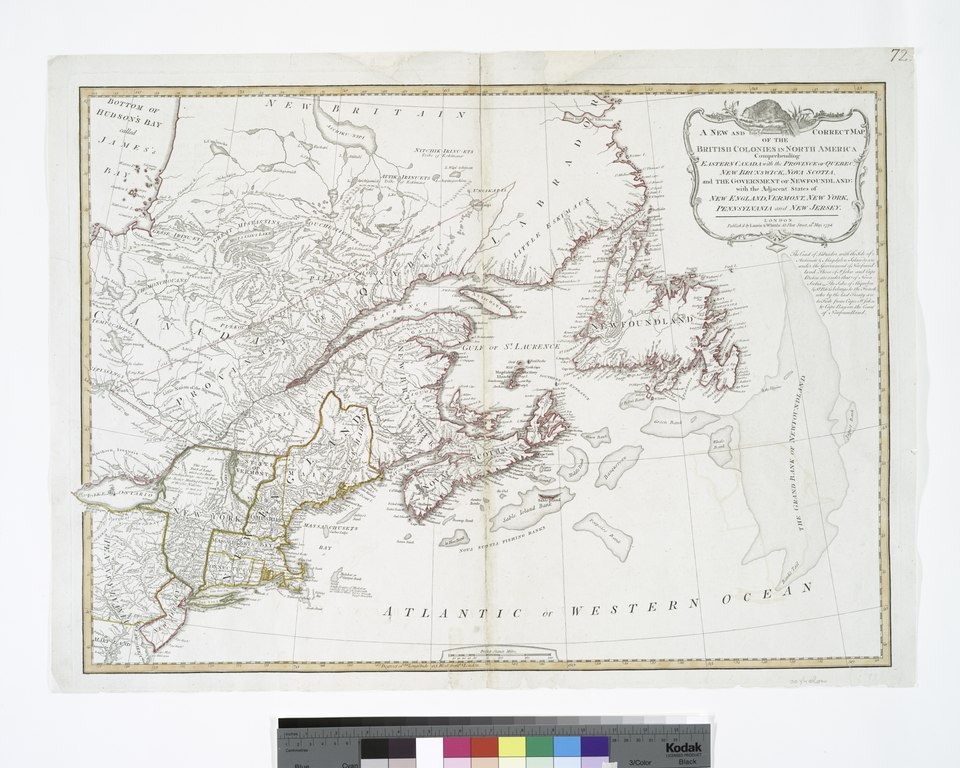
edit| Description | A New and correct map of the British colonies in North America comprehending eastern Canada with the province of Quebec, New Brunswick, Nova Scotia, and the Government of Newfoundland : with the adjacent states of New England, Vermont, New York, Pennsylvania and New Jersey. | |||||||||||||||||||||||
| Notes | Appears in Laurie & Whittle's New and elegant imperial sheet atlas, 1800. Note 2.) Includes note. Note 3.) Lawrence H. Slaughter Collection ; 695. Note 4.) National Endowment for the Humanities Grant for Access to Early Maps of the Middle Atlantic Seaboard. Note 5.) NYPL copy in Map Div. 97-6385 has "72" handwritten in ink in upper right corner. Note 6.) Prime meridian: London. Note 7.) Shows boundaries of states. Note 8.) Relief shown pictorially. | |||||||||||||||||||||||
| Standard reference | Phillips 6016 | |||||||||||||||||||||||
| Physical description | 1 map : hand col. ; 47 x 66 cm. | |||||||||||||||||||||||
| Catalog Call Number | Map Div. 97-6385 [LHS 695] | |||||||||||||||||||||||
| Date | ||||||||||||||||||||||||
| Source |
http://digitalgallery.nypl.org/nypldigital/dgkeysearchdetail.cfm?imageID=489846
|
|||||||||||||||||||||||
| Author | Robert Laurie and James Whittle -- Publisher | |||||||||||||||||||||||
| Permission (Reusing this file) |
From The Lionel Pincus & Princess Firyal Map Division. Released on a CC0 license.[1] | |||||||||||||||||||||||
| Digital ID | 489846 | |||||||||||||||||||||||
| Location | Stephen A. Schwarzman Building / The Lionel Pincus and Princess Firyal Map Division | |||||||||||||||||||||||
| NYPL digital item published | 11-5-2004; updated 3-25-2011 | |||||||||||||||||||||||

Licensing
edit| This file is made available under the Creative Commons CC0 1.0 Universal Public Domain Dedication. | |
| The person who associated a work with this deed has dedicated the work to the public domain by waiving all of their rights to the work worldwide under copyright law, including all related and neighboring rights, to the extent allowed by law. You can copy, modify, distribute and perform the work, even for commercial purposes, all without asking permission.
|
The making of this file was supported by Wikimedia UK.
To see other files made with the support of Wikimedia UK, please see the category Supported by Wikimedia UK.
|
File history
Click on a date/time to view the file as it appeared at that time.
| Date/Time | Thumbnail | Dimensions | User | Comment | |
|---|---|---|---|---|---|
| current | 19:17, 11 October 2014 |  | 5,139 × 4,112 (34.55 MB) | Finavon (talk | contribs) | rotated |
| 12:18, 6 April 2014 |  | 4,112 × 5,139 (60.46 MB) | Fæ (talk | contribs) | =={{int:filedesc}}== {{NYPL_map |digital_id = 489846 |standard_reference = Phillips 6016 |record_id = 337861 |catalog_call_number = Map Div. 97-6385 [LHS 695] |item_physical_description = 1 map : hand col. ; 47 x 66 cm. |link_catalog = http://digitalga... |
You cannot overwrite this file.
File usage on Commons
There are no pages that use this file.