File:A busy transport intersection - geograph.org.uk - 490131.jpg
A_busy_transport_intersection_-_geograph.org.uk_-_490131.jpg (640 × 477 pixels, file size: 126 KB, MIME type: image/jpeg)
Captions
Captions
Summary edit
| Description |
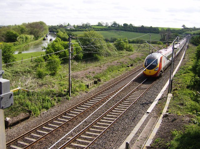
English: A busy transport intersection Four forms of transport to talk about here, spanning perhaps 2,000 years of transport history. Starting with the most recent.
This is the railway line from London to Birmingham, Manchester and Glasgow. This section was built in 1839 as the London and Birmingham Railway, becoming the London and North Western in 1846 and part of the London Midland and Scottish upon grouping in 1923. It was electrified in 1966 and more recently has become known as the West Coast Main Line. Railway re-privatisation saw the franchise won by Virgin Trains. Another major upgrade took place between 2003 and 2006 with the fastest trains now operated with Pendolino tilting trains, as seen here. This train has just emerged from Stowe Hill tunnel doing about 105mph and is starting to tilt for the reverse curves (double bend) through Weedon behind us. To its left is the canal originally built in 1793 between London and Braunston as the Grand Junction Canal, where in linked with other canals to form a direct route to Birmingham. The canal company merged with others in 1929 to become the Grand Union Canal, and was followed during the 1930's by extensive modernisation, including lock widening. However trade continued to decline, suffering particularly badly in the fierce winter of 1962/3 and coming to a virtual end in the 1980's. The canal is now a popular holiday route and the towpath forms the long distance London to Birmingham canal walk. The bridge is crossed by the Macmillan Way, a 290-mile long distance coast-to-coast walk from Lincolnshire to Dorset. The oldest transport link is the Roman road, Watling Street, from London to their northern stronghold of Chester. This section was also used by Thomas Telford in the early 1800's for his London to Holyhead Road, now the A5 and once the main road north until bypassed by the M1. It can be seen crossing the canal and climbing Stowe Hill by the house above the first pylon. 2,000 years of transport, most of it crammed into this one grid square. Now which primary geographical category should I use? |
| Date | |
| Source | From geograph.org.uk |
| Author | Graham Horn |
| Attribution (required by the license) | Graham Horn / A busy transport intersection / |
| Camera location | | View this and other nearby images on: OpenStreetMap |
|---|
_heading:112.00&language=en)
| Object location | | View this and other nearby images on: OpenStreetMap |
|---|
_heading:112.00&language=en)
Licensing edit

|
This image was taken from the Geograph project collection. See this photograph's page on the Geograph website for the photographer's contact details. The copyright on this image is owned by Graham Horn and is licensed for reuse under the Creative Commons Attribution-ShareAlike 2.0 license.
|
- You are free:
- to share – to copy, distribute and transmit the work
- to remix – to adapt the work
- Under the following conditions:
- attribution – You must give appropriate credit, provide a link to the license, and indicate if changes were made. You may do so in any reasonable manner, but not in any way that suggests the licensor endorses you or your use.
- share alike – If you remix, transform, or build upon the material, you must distribute your contributions under the same or compatible license as the original.
File history
Click on a date/time to view the file as it appeared at that time.
| Date/Time | Thumbnail | Dimensions | User | Comment | |
|---|---|---|---|---|---|
| current | 04:11, 5 February 2011 | | 640 × 477 (126 KB) | GeographBot (talk | contribs) | == {{int:filedesc}} == {{Information |description={{en|1=A busy transport intersection Four forms of transport to talk about here, spanning perhaps 2,000 years of transport history. Starting with the most recent. This is the railway line from London t |
You cannot overwrite this file.
File usage on Commons
There are no pages that use this file.