File:A copy of ... the fourth and fifth ranges of townships in the Kennebec Million Acres LOC 91685214.tif

Size of this JPG preview of this TIF file: 800 × 339 pixels. Other resolutions: 320 × 135 pixels | 640 × 271 pixels | 1,024 × 434 pixels | 1,280 × 542 pixels | 2,560 × 1,084 pixels | 12,602 × 5,335 pixels.
Original file (12,602 × 5,335 pixels, file size: 192.35 MB, MIME type: image/tiff)
Captions
Captions
Add a one-line explanation of what this file represents
Summary
edit| Description |
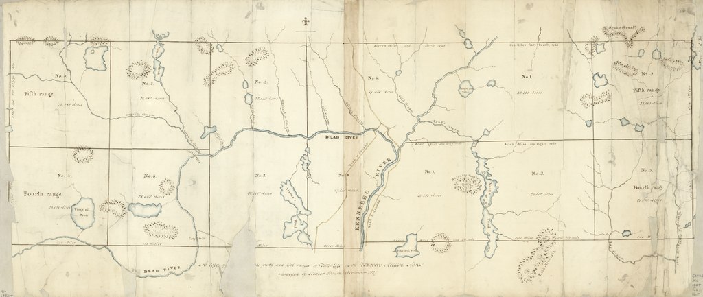
English: Covers a portion of the Kennebec River region of Maine that is centered on the confluence of the Kennebec and Dead Rivers. Relief shown by hachures. Pen-and-ink and watercolor. Has watermarks. Available also through the Library of Congress Web site as a raster image. Imperfect: Tears and missing sections (one of which involves part of the title) along edges. Vault |
||
| Title | A copy of ... the fourth and fifth ranges of townships in the Kennebec Million Acres | ||
| Shelf ID | G3732.K4 1827 .C6 | ||
| Date | |||
| Source | https://www.loc.gov/item/91685214/ | ||
| Author | Coburn, Eleazer | ||
| Permission (Reusing this file) |
|
||
| Other versions |
|
||
| Location | United States · Kennebec River Region · Maine | ||
| Part of | American Memory · General Maps · Catalog · Geography And Map Division | ||
| Subject | Maps, Manuscript · United States · Kennebec River Region (Me.) · Kennebec River Region · Maine · Manuscript Maps |


Licensing
edit|
This is a faithful photographic reproduction of a two-dimensional, public domain work of art. The work of art itself is in the public domain for the following reason:
The official position taken by the Wikimedia Foundation is that "faithful reproductions of two-dimensional public domain works of art are public domain".
This photographic reproduction is therefore also considered to be in the public domain in the United States. In other jurisdictions, re-use of this content may be restricted; see Reuse of PD-Art photographs for details. | ||||
File history
Click on a date/time to view the file as it appeared at that time.
| Date/Time | Thumbnail | Dimensions | User | Comment | |
|---|---|---|---|---|---|
| current | 21:02, 20 May 2018 |  | 12,602 × 5,335 (192.35 MB) | Fæ (talk | contribs) | LOC Maps https://www.loc.gov/item/91685214/ #12481 |
You cannot overwrite this file.
File usage on Commons
The following page uses this file: