File:A general map of the middle British colonies in America- Viz. Virginia, Maryland, Delaware, Pensilvania, New-Jersey, New-York, Connecticut, and Rhode-Island- Of Aquanishuonîgy the country of the LOC gm71000789.tif

Size of this JPG preview of this TIF file: 800 × 592 pixels. Other resolutions: 320 × 237 pixels | 640 × 474 pixels | 1,024 × 758 pixels | 1,280 × 947 pixels | 2,560 × 1,894 pixels | 7,996 × 5,917 pixels.
Original file (7,996 × 5,917 pixels, file size: 135.36 MB, MIME type: image/tiff)
Captions
Captions
Add a one-line explanation of what this file represents
Summary edit
| Description |
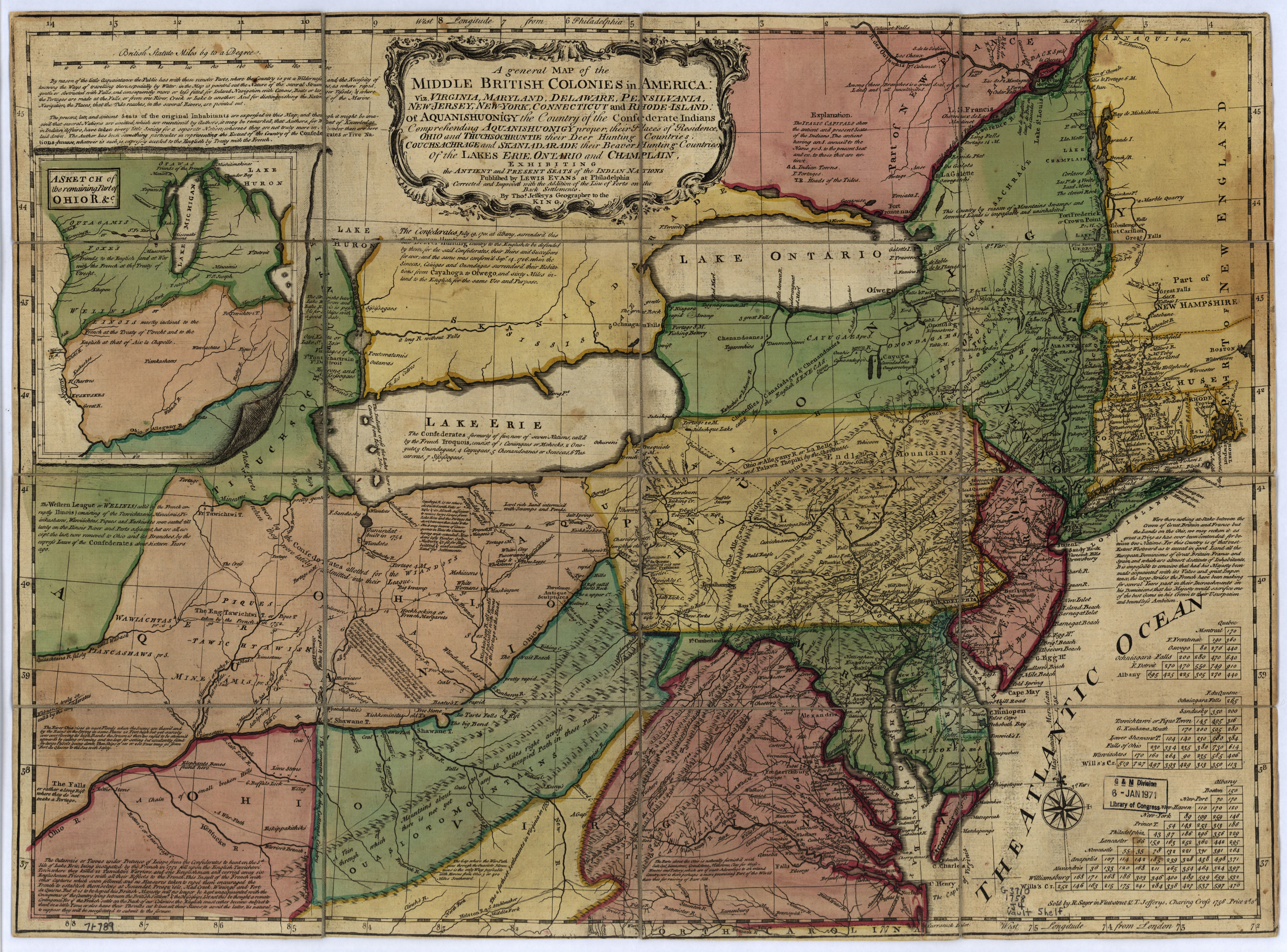
English: Scale ca. 1:2,250,000. Hand colored. Prime meridian: London and Philadelphia. Relief shown pictorially. Includes numerous notes, especially concerning inland water communications and natural resources, 3 distance charts, and inset of "A sketch of the remaining part of Ohio R. &c." Has extensive coloration and numerous boundaries that do not coincide with printed boundaries LC Maps of North America, 1750-1789, 713 Available also through the Library of Congress Web site as a raster image. Vault AACR2 |
||
| Title | A general map of the middle British colonies in America: Viz. Virginia, Maryland, Delaware, Pensilvania, New-Jersey, New-York, Connecticut, and Rhode-Island: Of Aquanishuonîgy the country of the Confederate Indians comprehending Aquanishuonigy proper, their places of residence, Ohio and Tuchsochruntie their deer hunting countries, Couchsachrage and Skaniadarade, their beaver hunting countries, of the Lakes Erie, Ontario, and Champlain, ... exhibiting the antient and present seats of the Indian nations. | ||
| Shelf ID | G3710 1758 .J41 | ||
| Date | |||
| Source | https://www.loc.gov/item/gm71000789/ | ||
| Author | Jefferys, Thomas; Evans, Lewis; Sayer, Robert | ||
| Permission (Reusing this file) |
|
||
| Other versions |
|
||
| Location | Northeastern States · United States | ||
| Part of | Military Battles And Campaigns · American Memory · Catalog · Geography And Map Division · American Revolution And Its Era: Maps And Charts Of North America And The West Indies, 1750-1789 | ||
| Subject | Northeastern States · Maps · Early Works To 1800 · United States |


Licensing edit
|
This is a faithful photographic reproduction of a two-dimensional, public domain work of art. The work of art itself is in the public domain for the following reason:
The official position taken by the Wikimedia Foundation is that "faithful reproductions of two-dimensional public domain works of art are public domain".
This photographic reproduction is therefore also considered to be in the public domain in the United States. In other jurisdictions, re-use of this content may be restricted; see Reuse of PD-Art photographs for details. | ||||
File history
Click on a date/time to view the file as it appeared at that time.
| Date/Time | Thumbnail | Dimensions | User | Comment | |
|---|---|---|---|---|---|
| current | 19:13, 24 May 2018 |  | 7,996 × 5,917 (135.36 MB) | Fæ (talk | contribs) | LOC Maps https://www.loc.gov/item/gm71000789/ #402 |
You cannot overwrite this file.
File usage on Commons
The following page uses this file: