File:A general map of the middle British colonies in America - viz. Virginia, Maryland, Delaware, Pensilvania, New-Jersey, New-York, Connecticut and Rhode-Island - of Aquanishuonigy the country (NYPL b14963771-1260174).tiff

Original file (5,482 × 4,480 pixels, file size: 70.27 MB, MIME type: image/tiff)
Captions
Captions
Summary edit
| Description |
English: * National Endowment for the Humanities Grant for Access to Early Maps of the Middle Atlantic Seaboard.
|
||
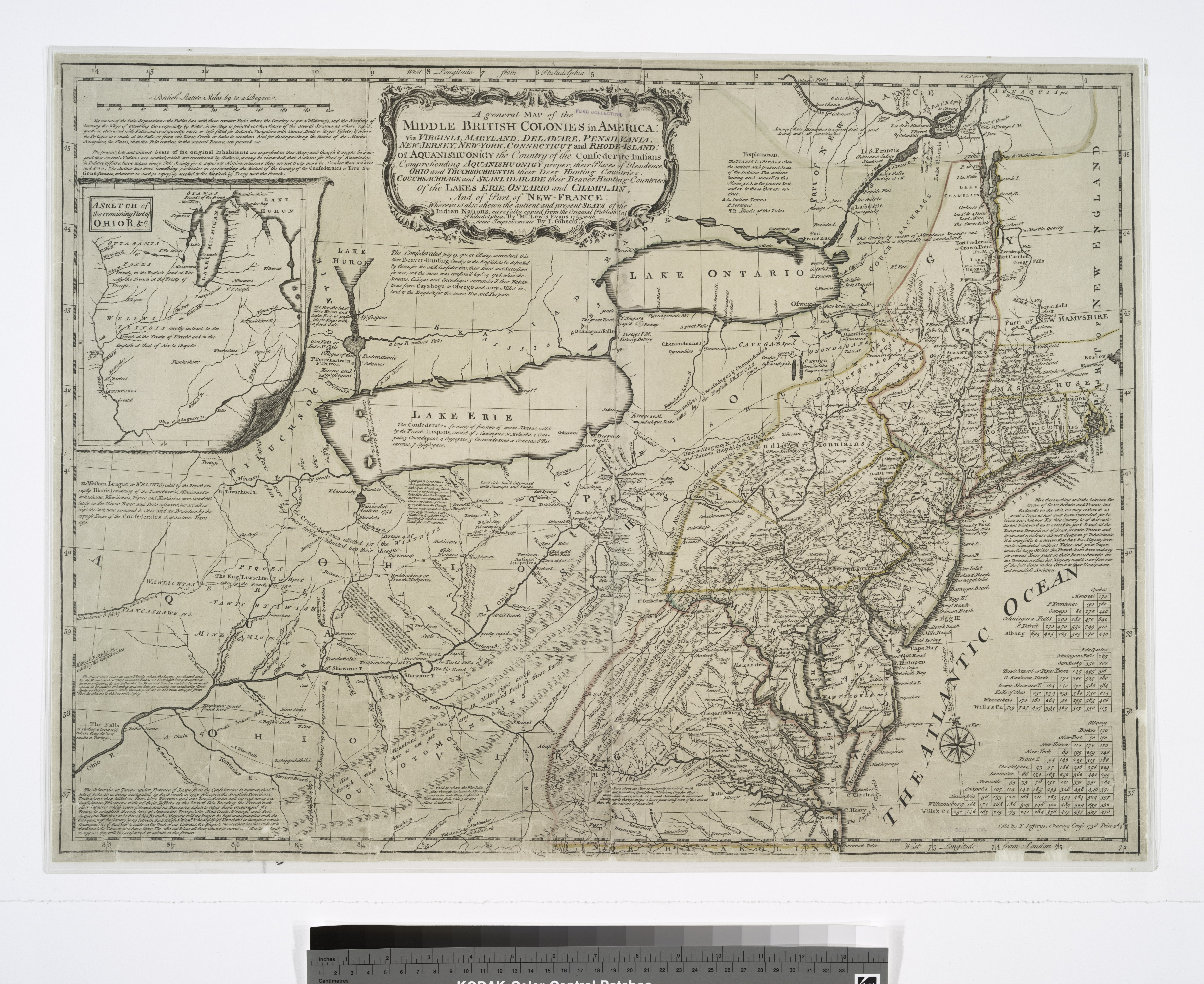
| Title | A general map of the middle British colonies in America : viz. Virginia, Maryland, Delaware, Pensilvania, New-Jersey, New-York, Connecticut and Rhode-Island : of Aquanishuonigy the country of the confederate Indians comprehending Aquanishuonigy proper, their places of residence, Ohio and Thuchsochruntie their deer hunting countries, Couchsachrage and Skaniadarade their beaver hunting countries, of the Lakes Erie, Ontario and Champlain, and of part of New-France : wherein is also shewn the antient and present seats of the Indian nations | ||
| Alternative title | Middle British colonies in America | ||
| Date | |||
| Source | https://digitalcollections.nypl.org/items/510d47df-f8bd-a3d9-e040-e00a18064a99 | ||
| Author | Scan by NYPL | ||
| Permission (Reusing this file) |
|
||
| UUID | 02dbc2b0-c52b-012f-b3c9-3c075448cc4b | ||
| MODS | http://api.repo.nypl.org/api/v1/items/mods/510d47df-f8bd-a3d9-e040-e00a18064a99 | ||
| Origin place | T. Jefferys | ||
| Image ID | 1260174 | ||
| Collection | Maps of North America | ||
| Collection UUID | 510d47df-f8bd-a3d9-e040-e00a18064a99 | ||
| NYPL catalog ID | b14963771 | ||
| Topics | Indians of North America |
Licensing edit
This image is in the public domain because it is a mere mechanical scan or photocopy of a public domain original, or – from the available evidence – is so similar to such a scan or photocopy that no copyright protection can be expected to arise. The original itself is in the public domain for the following reason:
This tag is designed for use where there may be a need to assert that any enhancements (eg brightness, contrast, colour-matching, sharpening) are in themselves insufficiently creative to generate a new copyright. It can be used where it is unknown whether any enhancements have been made, as well as when the enhancements are clear but insufficient. For known raw unenhanced scans you can use an appropriate {{PD-old}} tag instead. For usage, see Commons:When to use the PD-scan tag.  | ||||
File history
Click on a date/time to view the file as it appeared at that time.
| Date/Time | Thumbnail | Dimensions | User | Comment | |
|---|---|---|---|---|---|
| current | 22:01, 11 June 2019 |  | 5,482 × 4,480 (70.27 MB) | SteinsplitterBot (talk | contribs) | Bot: Image rotated by 270° |
| 11:43, 10 July 2016 |  | 4,480 × 5,482 (70.27 MB) | Fæ (talk | contribs) | NYPL maps http://digitalcollections.nypl.org/items/510d47df-f8bd-a3d9-e040-e00a18064a99, part of User:Fæ/Project list/NYPL T556.1571 |
You cannot overwrite this file.
File usage on Commons
There are no pages that use this file.