File:A map of the British and French dominions in North America with the roads, distances, limits, and extent of the settlements, & forts, as they are now. LOC 74696188.jpg

Size of this preview: 791 × 599 pixels. Other resolutions: 317 × 240 pixels | 634 × 480 pixels | 1,014 × 768 pixels | 1,280 × 970 pixels | 2,560 × 1,940 pixels | 7,006 × 5,308 pixels.
Original file (7,006 × 5,308 pixels, file size: 5.87 MB, MIME type: image/jpeg)
Captions
Captions
Add a one-line explanation of what this file represents
Summary edit
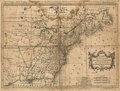
| Description |
English: Scale ca. 1:7,000,000. Alternate title: Carte des possessions Angloises & Françoises du continent de l'Amérique septentrionale. Par I. Palairet. Relief shown pictorially. Prime meridian: London and Ferro. French and English. Designed to show possessions by color, not colored. LC Maps of North America, 1750-1789, 84 Available also through the Library of Congress Web site as a raster image. LC copy annotated in blue, red, and green ink. Vault AACR2: 100; 651/1; 700/1; 700/2 |
||
| Title | A map of the British and French dominions in North America with the roads, distances, limits, and extent of the settlements, & forts, as they are now. | ||
| Shelf ID | G3300 1759 .R6 | ||
| Date | |||
| Source | https://www.loc.gov/item/74696188/ | ||
| Author | Rocque, John; Palairet, Jean; Kitchin, Thomas | ||
| Permission (Reusing this file) |
|
||
| Other versions |
|
||
| Location | North America | ||
| Part of | Military Battles And Campaigns · American Memory · Catalog · Geography And Map Division · American Revolution And Its Era: Maps And Charts Of North America And The West Indies, 1750-1789 | ||
| Subject | North America · Maps · Early Works To 1800 |

Licensing edit
|
This is a faithful photographic reproduction of a two-dimensional, public domain work of art. The work of art itself is in the public domain for the following reason:
The official position taken by the Wikimedia Foundation is that "faithful reproductions of two-dimensional public domain works of art are public domain".
This photographic reproduction is therefore also considered to be in the public domain in the United States. In other jurisdictions, re-use of this content may be restricted; see Reuse of PD-Art photographs for details. | ||||
File history
Click on a date/time to view the file as it appeared at that time.
| Date/Time | Thumbnail | Dimensions | User | Comment | |
|---|---|---|---|---|---|
| current | 04:47, 2 June 2018 | | 7,006 × 5,308 (5.87 MB) | Fæ (talk | contribs) | LOC Maps https://www.loc.gov/item/74696188/ #17686 |
You cannot overwrite this file.
File usage on Commons
The following page uses this file: