File:A map of the Province of New-York reduc'd from the large drawing of that Province, compiled from actual surveys by order of His Excellency William Tryon, Esqr., Captain General & Governor of the same, LOC 74692660.tif
Size of this JPG preview of this TIF file: 476 × 599 pixels. Other resolutions: 191 × 240 pixels | 381 × 480 pixels | 610 × 768 pixels | 814 × 1,024 pixels | 1,627 × 2,048 pixels | 5,639 × 7,097 pixels.
Original file (5,639 × 7,097 pixels, file size: 114.5 MB, MIME type: image/tiff)
Captions
Captions
Add a one-line explanation of what this file represents
Summary edit
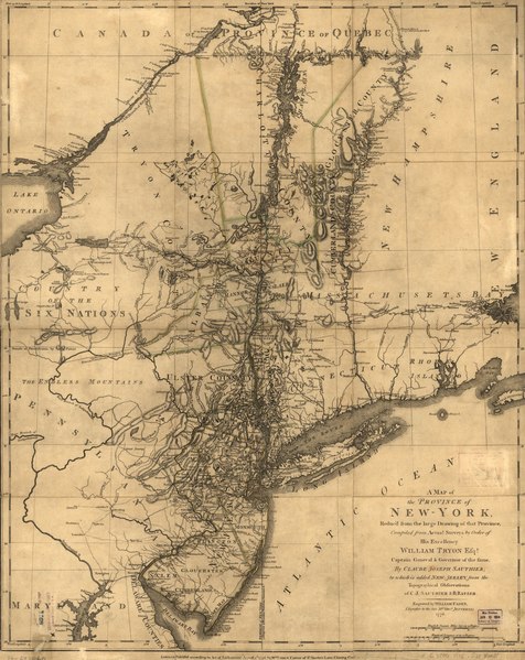
| Description |
English: Scale ca. 1:1,050,000. Hand colored. LC copy mounted on cloth backing. Relief shown by hachures. Differs from other copies: Western boundary of Tryon County and eastern boundaries of Cumberland and Glocester counties not colored. Shows administrative boundaries in New York and New Jersey. Also shows portions of Pennsylvania and New England. Appears in William Faden's The North American atlas. 1777. LC Maps of North America, 1750-1789, 1047 Available also through the Library of Congress Web site as a raster image. Vault AACR2 |
||
| Title | A map of the Province of New-York reduc'd from the large drawing of that Province, compiled from actual surveys by order of His Excellency William Tryon, Esqr., Captain General & Governor of the same, by Claude Joseph Sauthier; to which is added New Jersey. | ||
| Shelf ID | G3800 1776 .S31 | ||
| Date | |||
| Source | https://www.loc.gov/item/74692660/ | ||
| Author | Sauthier, Claude Joseph; Ratzer, Bernard; Faden, William | ||
| Permission (Reusing this file) |
|
||
| Other versions |
|
||
| Location | New Jersey · United States · New York (State) · Northeastern States · New York | ||
| Part of | Military Battles And Campaigns · American Memory · Catalog · Geography And Map Division · American Revolution And Its Era: Maps And Charts Of North America And The West Indies, 1750-1789 | ||
| Subject | United States · New Jersey · Northeastern States · Maps · Early Works To 1800 · Administrative And Political Divisions · New York (State) |


Licensing edit
|
This is a faithful photographic reproduction of a two-dimensional, public domain work of art. The work of art itself is in the public domain for the following reason:
The official position taken by the Wikimedia Foundation is that "faithful reproductions of two-dimensional public domain works of art are public domain".
This photographic reproduction is therefore also considered to be in the public domain in the United States. In other jurisdictions, re-use of this content may be restricted; see Reuse of PD-Art photographs for details. | ||||
File history
Click on a date/time to view the file as it appeared at that time.
| Date/Time | Thumbnail | Dimensions | User | Comment | |
|---|---|---|---|---|---|
| current | 00:40, 18 May 2018 |  | 5,639 × 7,097 (114.5 MB) | Fæ (talk | contribs) | LOC Maps https://www.loc.gov/item/74692660/ #10477 |
You cannot overwrite this file.
File usage on Commons
The following page uses this file: