File:A new and accurate map of the English empire in North America- Representing their rightful claim as confirm'd by charters, and the formal surrender of their Indian friends; likewise the encroachments LOC 74695024.jpg

Size of this preview: 696 × 600 pixels. Other resolutions: 278 × 240 pixels | 557 × 480 pixels | 891 × 768 pixels | 1,188 × 1,024 pixels | 2,376 × 2,048 pixels | 6,154 × 5,305 pixels.
Original file (6,154 × 5,305 pixels, file size: 5.87 MB, MIME type: image/jpeg)
Captions
Captions
Add a one-line explanation of what this file represents
Summary edit
| Description |
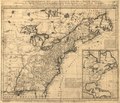
English: Scale ca. 1:7,000,000. Relief shown pictorially. Designed to be colored. Not colored. "Sold by Wm. Herbert on London Bridge & Robt. Sayer over against Fetter Lane in Fleet Street." LC Maps of North America, 1750-1789, 28 Includes inset showing North America from Hudson's Bay to Panama. Available also through the Library of Congress Web site as a raster image. Vault AACR2: 110; 651/1; 650/2; 700/1; 700/2; 710 |
||
| Title | A new and accurate map of the English empire in North America: Representing their rightful claim as confirm'd by charters, and the formal surrender of their Indian friends; likewise the encroachments of the French, with the several forts they have unjustly erected therein. | ||
| Shelf ID | G3300 1755 .H4 | ||
| Date | |||
| Source | https://www.loc.gov/item/74695024/ | ||
| Author | Herbert, William; Sayer, Robert; Society Of Anti-Gallicans | ||
| Permission (Reusing this file) |
|
||
| Other versions |
|
||
| Location | North America · America | ||
| Part of | Military Battles And Campaigns · American Memory · Catalog · Geography And Map Division · American Revolution And Its Era: Maps And Charts Of North America And The West Indies, 1750-1789 | ||
| Subject | North America · Maps · Early Works To 1800 · America · British |

Licensing edit
|
This is a faithful photographic reproduction of a two-dimensional, public domain work of art. The work of art itself is in the public domain for the following reason:
The official position taken by the Wikimedia Foundation is that "faithful reproductions of two-dimensional public domain works of art are public domain".
This photographic reproduction is therefore also considered to be in the public domain in the United States. In other jurisdictions, re-use of this content may be restricted; see Reuse of PD-Art photographs for details. | ||||
File history
Click on a date/time to view the file as it appeared at that time.
| Date/Time | Thumbnail | Dimensions | User | Comment | |
|---|---|---|---|---|---|
| current | 11:47, 10 October 2018 | | 6,154 × 5,305 (5.87 MB) | Fæ (talk | contribs) | LOC Maps https://www.loc.gov/item/74695024/ #4213 |
You cannot overwrite this file.
File usage on Commons
The following page uses this file: