File:A new map of ancient Greece Thrace, Moesia, Ilyricum and the isles adjoyning. NYPL1630713.tiff

Size of this JPG preview of this TIF file: 799 × 600 pixels. Other resolutions: 320 × 240 pixels | 640 × 480 pixels | 1,023 × 768 pixels | 1,280 × 961 pixels | 2,560 × 1,922 pixels | 7,230 × 5,428 pixels.
Original file (7,230 × 5,428 pixels, file size: 112.28 MB, MIME type: image/tiff)
Captions
Captions
Add a one-line explanation of what this file represents
Summary edit
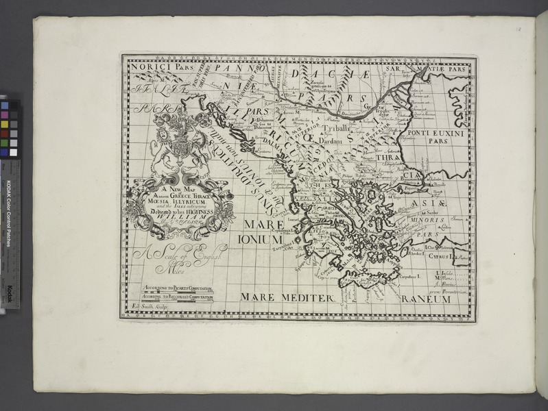
| Description | A new map of ancient Greece Thrace, Moesia, Ilyricum and the isles adjoyning.; Lawrence H. Slaughter Collection of English maps, charts, globes, books and atlases / Atlases / A new sett of maps both of antient and present geography : wherein not only the latitude and longitude of many places are corrected according to the latest observations, but also the most remarkable differences of antient and present geography may be quickly discern'd by a bare inspection or comparing of correspondent maps, which seems to be the most natural and easy method to lead young students (for whose use the work is principally intended) unto a competent knowledge of the geographical science : together with a geographical treatise particularly adapted to the use and design of these maps / by Edward Wells, M.A. and student of Christ-Church, Oxon. | |||||||||||||||||||||||
| Notes | A Scales of English miles: According to Picart's computation, According to Ricciolus's computation. | |||||||||||||||||||||||
| Catalogue call number | Map Div. 97-6038[LHS 313; atlas cases] | |||||||||||||||||||||||
| Item/Page/Plate | [Map 18] | |||||||||||||||||||||||
| Alternate title | Greece, Thrace, Illyricum, etc | |||||||||||||||||||||||
| Standard reference | Phillips 531 | |||||||||||||||||||||||
| Date | ||||||||||||||||||||||||
| Source |
http://digitalgallery.nypl.org/nypldigital/dgkeysearchdetail.cfm?imageID=1630713
|
|||||||||||||||||||||||
| Author | Wells, Edward, 1667-1727 -- Cartographer | |||||||||||||||||||||||
| Permission (Reusing this file) |
From The Lionel Pincus and Princess Firyal Map Division. http://maps.nypl.org
|
|||||||||||||||||||||||
| Source description | 1 atlas ([43] leaves (2 folded)) : 41 maps ; 53 x 69 cm. | |||||||||||||||||||||||
| Location | Stephen A. Schwarzman Building / The Lionel Pincus and Princess Firyal Map Division | |||||||||||||||||||||||
| Digital item published | 5-12-2008; updated 1-9-2012 | |||||||||||||||||||||||
| Digital ID | 1630713 | |||||||||||||||||||||||

The making of this file was supported by Wikimedia UK.
To see other files made with the support of Wikimedia UK, please see the category Supported by Wikimedia UK.
|
File history
Click on a date/time to view the file as it appeared at that time.
| Date/Time | Thumbnail | Dimensions | User | Comment | |
|---|---|---|---|---|---|
| current | 22:14, 28 April 2014 |  | 7,230 × 5,428 (112.28 MB) | Fæ (talk | contribs) | GWToolset:: Creating mediafile for Fæ. Tranche 3 5495-7474 (2) |
You cannot overwrite this file.
File usage on Commons
There are no pages that use this file.