File:A plan of the division line between the provinces of New-York and Quebec. In the 45th degree of north latitude. Survey'd in the year 1771 & 1772. LOC 74694111.tif
Size of this JPG preview of this TIF file: 800 × 162 pixels. Other resolutions: 320 × 65 pixels | 640 × 129 pixels | 1,024 × 207 pixels | 1,280 × 258 pixels | 2,560 × 517 pixels | 16,006 × 3,232 pixels.
Original file (16,006 × 3,232 pixels, file size: 148 MB, MIME type: image/tiff)
Captions
Captions
Add a one-line explanation of what this file represents
Summary edit
| Description |
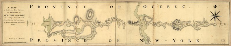
English: Scale ca. 1:125,000. Manuscript, black and red ink and watercolor. Relief shown by hachures. Map shows primarily Vermont with Québec (Province) and New York (State) LC Maps of North America, 1750-1789, 1071 Available also through the Library of Congress Web site as a raster image. Vault AACR2: 651/1; 651/2; 650/3; 700/1; 700/2 |
||
| Title | A plan of the division line between the provinces of New-York and Quebec. In the 45th degree of north latitude. Survey'd in the year 1771 & 1772. | ||
| Shelf ID | G3751.F2 1772 .V3 | ||
| Date | |||
| Source | https://www.loc.gov/item/74694111/ | ||
| Author | Valentine, Thomas; Sauthier, Claude Joseph; Collins, John | ||
| Permission (Reusing this file) |
|
||
| Other versions |
|
||
| Location | Canada · Vermont · United States · Québec · New York · New York (State) · Québec (Province) | ||
| Part of | Military Battles And Campaigns · American Memory · Catalog · Geography And Map Division · American Revolution And Its Era: Maps And Charts Of North America And The West Indies, 1750-1789 | ||
| Subject | Canada · United States · Vermont · Boundaries · Maps · Early Works To 1800 · New York (State) · Québec (Province) · Manuscript Maps |

Licensing edit
|
This is a faithful photographic reproduction of a two-dimensional, public domain work of art. The work of art itself is in the public domain for the following reason:
The official position taken by the Wikimedia Foundation is that "faithful reproductions of two-dimensional public domain works of art are public domain".
This photographic reproduction is therefore also considered to be in the public domain in the United States. In other jurisdictions, re-use of this content may be restricted; see Reuse of PD-Art photographs for details. | ||||
File history
Click on a date/time to view the file as it appeared at that time.
| Date/Time | Thumbnail | Dimensions | User | Comment | |
|---|---|---|---|---|---|
| current | 03:51, 22 May 2018 | 16,006 × 3,232 (148 MB) | Fæ (talk | contribs) | LOC Maps https://www.loc.gov/item/74694111/ #13133 |
You cannot overwrite this file.
File usage on Commons
The following page uses this file: