File:A plan of the operations of the King's army - under the command of General Sr. William Howe, K.B. in New York and East New Jersey, against the American forces commanded by General Washington, from the NYPL434804.tiff
Size of this JPG preview of this TIF file: 439 × 599 pixels. Other resolutions: 176 × 240 pixels | 352 × 480 pixels | 563 × 768 pixels | 750 × 1,024 pixels | 1,501 × 2,048 pixels | 3,562 × 4,860 pixels.
Original file (3,562 × 4,860 pixels, file size: 49.53 MB, MIME type: image/tiff)
Captions
Captions
Add a one-line explanation of what this file represents
Summary edit
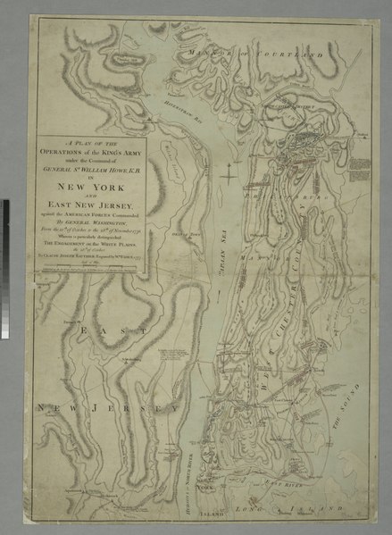
| Description | A plan of the operations of the King's army : under the command of General Sr. William Howe, K.B. in New York and East New Jersey, against the American forces commanded by General Washington, from the 12th of October, to the 28th of November 1776, wherein is particularly distinguished the engagement on the White Plains, the 28th of October / by Claude Joseph Sauthier ; engraved by Wm. Faden, 1777. | |||||||||||||||||||||||
| Notes | Includes descriptive notes. Note 2.) National Endowment for the Humanities Grant for Access to Early Maps of the Middle Atlantic Seaboard. Note 3.) Relief shown by hachures. | |||||||||||||||||||||||
| Physical description | 1 map : hand col. ; 73 x 50 cm. | |||||||||||||||||||||||
| Catalog Call Number | Map Div. 01-466 [Filed with N.Y.S. Revol. War, White Plains, Battle of, 1776] | |||||||||||||||||||||||
| Date | Feby. 25th, 1777 | |||||||||||||||||||||||
| Source |
http://digitalgallery.nypl.org/nypldigital/dgkeysearchdetail.cfm?imageID=434804
|
|||||||||||||||||||||||
| Author | Sauthier, Claude Joseph -- Cartographer ;Faden, William, 1750?-1836 -- Engraver | |||||||||||||||||||||||
| Permission (Reusing this file) |
From The Lionel Pincus & Princess Firyal Map Division. Released on a CC0 license.[1] | |||||||||||||||||||||||
| Digital ID | 434804 | |||||||||||||||||||||||
| Location | Stephen A. Schwarzman Building / The Lionel Pincus and Princess Firyal Map Division | |||||||||||||||||||||||
| NYPL digital item published | 9-26-2005; updated 3-25-2011 | |||||||||||||||||||||||

Licensing edit
| This file is made available under the Creative Commons CC0 1.0 Universal Public Domain Dedication. | |
| The person who associated a work with this deed has dedicated the work to the public domain by waiving all of their rights to the work worldwide under copyright law, including all related and neighboring rights, to the extent allowed by law. You can copy, modify, distribute and perform the work, even for commercial purposes, all without asking permission.
|
The making of this file was supported by Wikimedia UK.
To see other files made with the support of Wikimedia UK, please see the category Supported by Wikimedia UK.
|
File history
Click on a date/time to view the file as it appeared at that time.
| Date/Time | Thumbnail | Dimensions | User | Comment | |
|---|---|---|---|---|---|
| current | 19:17, 9 April 2014 |  | 3,562 × 4,860 (49.53 MB) | Fæ (talk | contribs) | =={{int:filedesc}}== {{NYPL_map |digital_id = 434804 |creators = Sauthier, Claude Joseph -- Cartographer ;Faden, William, 1750?-1836 -- Engraver |record_id = 253436 |catalog_call_number = Map Div. 01-466 [Filed with N.Y.S. Revol. War, White Plains, Bat... |
You cannot overwrite this file.
File usage on Commons
There are no pages that use this file.