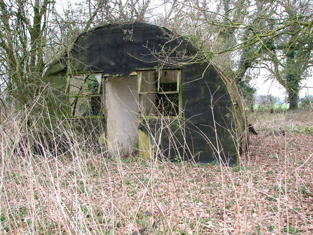
File:Dilapidated Nissen hut at Scole, Norfolk, England - geograph.org.uk - 1769906.jpg
(Redirected from File:A relic from another time - geograph.org.uk - 1769906.jpg)
Dilapidated_Nissen_hut_at_Scole,_Norfolk,_England_-_geograph.org.uk_-_1769906.jpg (640 × 480 pixels, file size: 204 KB, MIME type: image/jpeg)
File information
Structured data
Captions
Captions
Add a one-line explanation of what this file represents
Summary edit
| DescriptionDilapidated Nissen hut at Scole, Norfolk, England - geograph.org.uk - 1769906.jpg |
English: A relic from another time. What appears to be an unused, abandoned and overgrown area > 1769886 adjoining Kiln Lane in the west turns out to be a WWII camp site on closer inspection, with many of the buildings still in place, albeit in a very derelict condition. The Nissen huts (or Quonset houses, as Americans call them) > 1769894 used to be home to airmen of the 100th Bomb Group. There used to be some seventy such sites spread across East Anglia, which for two years during World War II had become launch pads for USAAF's bombing raids into occupied Europe. Each airfield was home to 2000-3000 airmen, most of them volunteers. These sites became known as 'The Fields of Little America' - this is one of them. The 100th Bomb Group Memorial Museum, dedicated to the USAAF's famous 'Bloody Hundredth' Bomb Group of WWII, is housed in the original airfield control tower > 1779828 near Thorpe Abbotts: http://www.100bgmus.org.uk/default.aspx |
| Date | |
| Source | From geograph.org.uk |
| Author | Evelyn Simak |
| Attribution (required by the license) InfoField | Evelyn Simak / A relic from another time / |
InfoField | Evelyn Simak / A relic from another time |
| Camera location | 52° 22′ 08″ N, 1° 11′ 35″ E | View this and other nearby images on: OpenStreetMap |
|---|
| Object location | 52° 22′ 08″ N, 1° 11′ 37″ E | View this and other nearby images on: OpenStreetMap |
|---|
Licensing edit

|
This image was taken from the Geograph project collection. See this photograph's page on the Geograph website for the photographer's contact details. The copyright on this image is owned by Evelyn Simak and is licensed for reuse under the Creative Commons Attribution-ShareAlike 2.0 license.
|
This file is licensed under the Creative Commons Attribution-Share Alike 2.0 Generic license.
Attribution: Evelyn Simak
- You are free:
- to share – to copy, distribute and transmit the work
- to remix – to adapt the work
- Under the following conditions:
- attribution – You must give appropriate credit, provide a link to the license, and indicate if changes were made. You may do so in any reasonable manner, but not in any way that suggests the licensor endorses you or your use.
- share alike – If you remix, transform, or build upon the material, you must distribute your contributions under the same or compatible license as the original.
File history
Click on a date/time to view the file as it appeared at that time.
| Date/Time | Thumbnail | Dimensions | User | Comment | |
|---|---|---|---|---|---|
| current | 20:20, 11 March 2011 |  | 640 × 480 (204 KB) | GeographBot (talk | contribs) | == {{int:filedesc}} == {{Information |description={{en|1=A relic from another time What appears to be an unused, abandoned and overgrown area > http://www.geograph.org.uk/photo/1769886 adjoining Kiln Lane in the west turns out to be a WWII camp site on cl |
You cannot overwrite this file.
File usage on Commons
The following 2 pages use this file:
Metadata
This file contains additional information such as Exif metadata which may have been added by the digital camera, scanner, or software program used to create or digitize it. If the file has been modified from its original state, some details such as the timestamp may not fully reflect those of the original file. The timestamp is only as accurate as the clock in the camera, and it may be completely wrong.
| Camera manufacturer | Canon |
|---|---|
| Camera model | Canon PowerShot S3 IS |
| Exposure time | 1/60 sec (0.016666666666667) |
| F-number | f/3.5 |
| Date and time of data generation | 14:22, 24 March 2010 |
| Lens focal length | 6 mm |
| Orientation | Normal |
| Horizontal resolution | 180 dpi |
| Vertical resolution | 180 dpi |
| File change date and time | 09:52, 25 March 2010 |
| Y and C positioning | Centered |
| Software used | Adobe Photoshop CS Windows |
| Exif version | 2.2 |
| Date and time of digitizing | 14:22, 24 March 2010 |
| Meaning of each component |
|
| Image compression mode | 5 |
| APEX shutter speed | 5.90625 |
| APEX aperture | 3.625 |
| APEX exposure bias | 0 |
| Maximum land aperture | 2.875 APEX (f/2.71) |
| Metering mode | Pattern |
| Flash | Flash did not fire, compulsory flash suppression |
| Supported Flashpix version | 1 |
| Color space | sRGB |
| Focal plane X resolution | 10,097.777777778 |
| Focal plane Y resolution | 10,082.840236686 |
| Focal plane resolution unit | inches |
| Sensing method | One-chip color area sensor |
| File source | Digital still camera |
| Custom image processing | Normal process |
| Exposure mode | Auto exposure |
| White balance | Auto white balance |
| Digital zoom ratio | 1 |
| Scene capture type | Standard |
| Supported Flashpix version | 1 |
| Image width | 640 px |
| Image height | 480 px |
| Date metadata was last modified | 09:52, 25 March 2010 |
