File:A view of ye general & coasting trade-winds, monsoons or ye shifting trade winds through ye world, variations etc - according to the newest and most exact observations - by H. Moll, geographer. NYPL465245.tiff
Size of this JPG preview of this TIF file: 800 × 340 pixels. Other resolutions: 320 × 136 pixels | 640 × 272 pixels | 1,024 × 436 pixels | 1,280 × 545 pixels | 2,560 × 1,089 pixels | 6,021 × 2,562 pixels.
Original file (6,021 × 2,562 pixels, file size: 44.16 MB, MIME type: image/tiff)
Captions
Captions
Add a one-line explanation of what this file represents
Summary edit
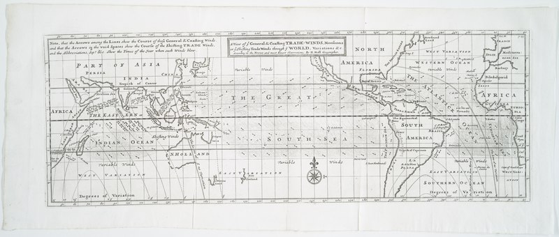
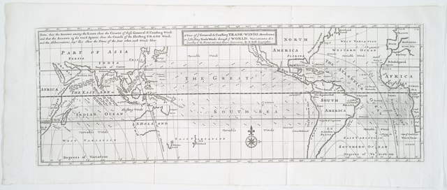
| Description | A view of ye general & coasting trade-winds, monsoons or ye shifting trade winds through ye world, variations &c.; : according to the newest and most exact observations / by H. Moll, geographer. | |||||||||||||||||||||||
| Notes | In upper right corner below neat line: p. 155. Note 2.) Includes note. Note 3.) Lawrence H. Slaughter Collection ; 1005. Note 4.) National Endowment for the Humanities Grant for Access to Early Maps of the Middle Atlantic Seaboard. | |||||||||||||||||||||||
| Physical description | 1 map ; 18 x 51 cm. | |||||||||||||||||||||||
| Catalog Call Number | Map Div. 97-6478 [LHS 1005] | |||||||||||||||||||||||
| Date | circa 1711 | |||||||||||||||||||||||
| Source |
http://digitalgallery.nypl.org/nypldigital/dgkeysearchdetail.cfm?imageID=465245
|
|||||||||||||||||||||||
| Author | Moll, Herman, d. 1732 -- Geographer (not in Relator list) | |||||||||||||||||||||||
| Permission (Reusing this file) |
From The Lionel Pincus & Princess Firyal Map Division. Released on a CC0 license.[1] | |||||||||||||||||||||||
| Digital ID | 465245 | |||||||||||||||||||||||
| Location | Stephen A. Schwarzman Building / The Lionel Pincus and Princess Firyal Map Division | |||||||||||||||||||||||
| NYPL digital item published | 2-3-2004; updated 3-25-2011 | |||||||||||||||||||||||

Licensing edit
| This file is made available under the Creative Commons CC0 1.0 Universal Public Domain Dedication. | |
| The person who associated a work with this deed has dedicated the work to the public domain by waiving all of their rights to the work worldwide under copyright law, including all related and neighboring rights, to the extent allowed by law. You can copy, modify, distribute and perform the work, even for commercial purposes, all without asking permission.
|
The making of this file was supported by Wikimedia UK.
To see other files made with the support of Wikimedia UK, please see the category Supported by Wikimedia UK.
|
File history
Click on a date/time to view the file as it appeared at that time.
| Date/Time | Thumbnail | Dimensions | User | Comment | |
|---|---|---|---|---|---|
| current | 10:53, 12 April 2014 |  | 6,021 × 2,562 (44.16 MB) | Fæ (talk | contribs) | Lossless crop and rotate (uploaded using chunked upload script) |
| 05:05, 11 April 2014 |  | 3,544 × 6,299 (63.87 MB) | Fæ (talk | contribs) | =={{int:filedesc}}== {{NYPL_map |digital_id = 465245 |catalog_call_number = Map Div. 97-6478 [LHS 1005] |record_id = 292167 |creator = Moll, Herman, d. 1732 -- Geographer (not in Relator list) |link_catalog = http://digitalgallery.nypl.org/nypldigital... |
You cannot overwrite this file.
File usage on Commons
The following 3 pages use this file: